What you see before you is an exposed example of basalt. Basalt is a common extrusive igneous (or volcanic) rock formed from the rapid cooling of basaltic lava. This area is part of the Roseburg Basalt Formation. The Roseburg Formation was named for the basalt and overlying interbedded sandstone and siltstone exposed in the Roseburg area. Investigation discovered over 200 fossils of planktonic basis. This means that the area was once underwater.
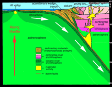
The west coast of the United States as we know it did not exist millions of years ago. It was formed by an accretionary wedge, pushing sediment against the North American continent, expanding the coast further west. An accretionary wedge is formed from sediment that is accreted onto the non-subducting tectonic plate at a convergent plate boundary. Along the west coast, two main tectonic plates collide, the Juan de Fuca plate and the North American plate. Juan de Fuca subducts under the North American plate, pushing/scraping sediment onto the North American plate.
Once the accretionary wedge was formed, basalt was distributed through the Roseburg area collectively by the Cascade eruptions.
The extensions of the Roseburg Formation:
North Latitude: 46° 16' 16" N (46.2711)
South Latitude: 41° 59' 30" N (41.9917)
East Longitude: 116° 27' 50" W (-116.4639)
West Longitude: 124° 33' 7" W (-124.5519)
QUESTIONS
1. From where you are standing, how high do you estimate the formation to be?
2. How many terraced layers do you see that were a result of blasting away to make room for development?