Czech:
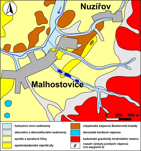
Tato earthcache je věnována různým druhům vápenců v okolí obce Malhostovice. Jejím cílem je ucelení představy o geologických procesech, které vedly ke vzniku takto rozdílných vápenců, a sice formou procházky, kde si lze jednotlivé výskyty vápenců prohlédnout jak z dálky, tak i zblízka.
Drásovský kopeček (waypoint 1)
Drásovský kopeček (jinými názvy Malá pecka nebo Čebínská pecka) představuje těleso tektonicky zapracované kry silně mylonitizovaných a kataklazovaných devonských vápenců, zakleslé do Boskovické brázdy při východním okraji brněnského masivu. Jedná se o světle šedé korálové vápence, které se podobají nejrozšířenějšímu typu vápenců v Moravském krasu. Narozdíl od nich jsou zdejší vápence tektonicky přepracované a patrně i o něco mladší. V rámci Boskovické brázdy vystupují jako morfologicky nápadné elevace.
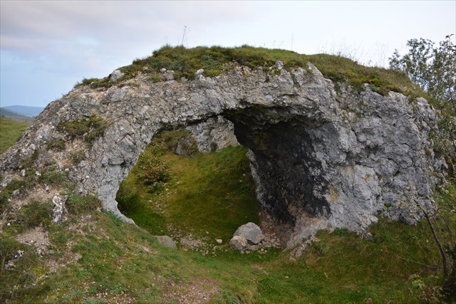
Útvar, který zde pozorujeme, označujeme jako skalní brána. Její vznik je podmíněn odlišnou náchylností k erozi mezi centrální a okrajovou partií silně deformovaného tělesa vápence
Malhostovická pecka (waypoint 2)
Malhostovická pecka je vápencové těleso nacházející se při jižním okraji Malhostovic, ležící v těsné blízkosti Drásovského kopečku. Jedná se o stejný typ vápence, avšak jako celek není tak výrazně tektonicky porušen.
V minulosti zde probíhala těžba vápence. V odkryvech lze nalézt fosilní zástupce devonské fauny, zejména korály a stromatopory. Mezi nejhojněji zastoupené tabulátní korály řadíme Alveolites parvus či Crassialveolites domrachevi, zástupcem rugózních (čtyřčetných) korálů je Frechastraea pentagona minima. Přítomnost korálů dokazuje stáří vápenců na stupeň devonu zvaný frasn.
Blok vápence „Pod Křibem“ (waypoint 3)
Pod lípou u Brněnského kříže lze spatřit blok devonského vápence pocházejíjcí s největší pravděpodobností z lokality viz úkol č. 5.
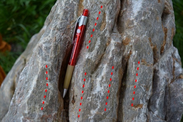
Na tomto vápenci lze pozorovat přítomnost nepravidelných bílých kalcitových žilek. Hornina vykazuje tektonické postižení, které se projevuje dvěma systémy puklin. Nás bude zajímat mladší a výraznější laminace (zbřidličnatění), ve které se držela srážková voda a podél ní docházelo k významnému fenoménu „krasovění“, který je typický zejména pro tzv. „vysokoprocentní vápence“, tj. vápence s výrazným podílem CaCO3. Zkrasovělé pukliny zvýrazňují tektonickou stavbu horniny (jdou paralelně s mladší laminací).
U Brabinky (waypoint 4)
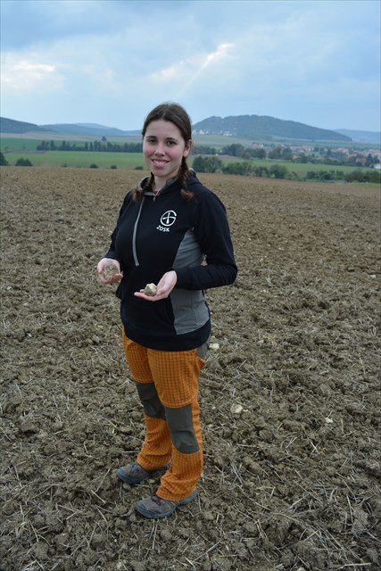
V okolí Malhostovic v polní trati „U Brabinky“ byl nově nalezen další typ vápenců, které s devonskými tělesy vápenců geneticky ani časově nesouvisí.
Jedná se o mikritické vápence obsahující četné kulovité objekty s převládající mikrokrystalickou vnitřní stavbou (peloidy/rekrystalizované ooidy) s předpokládaným jurským stářím, které jsou postiženy různým stupněm silicifikace - obsahují tmavě zbarvené polohy rohovců, které se staly předmětem těžby a zpracování již v mladší době kamenné. Tyto vápence vznikaly v občasně zaplavovaných příbřežních lagunách, které jsou analogické recentním sabchám. Jedná se o zcela mimořádné a extrémní sedimentační prostředí, ve kterém zpravidla nedochází k zachování žádných fosílií.
Úkoly
Pro uznání logu „Found it“ je nutné splnit následující úlohy:
1) Jak se nazývá typ horniny, který vznikl tektonickým drcením vápence na Drásovském kopečku (waypoint 1)?
2) Proč na Drásovském kopečku (waypoint 1) nelze nalézt zachovalé fosílie?
3) Najdi na skalním útvaru (waypoint 1) tektonické ohlazy s rýhováním. Vyfoť detail a použij GPS jako měřítko. Fotografii pak přilož k logu.
4) Podívej se na detail horniny na Malhostovické pecce (waypoint 2). V čem se zdejší vápenec makroskopicky liší od horniny na Drásovském kopečku?
5) Uveď název největší čočky devonských vápenců, kterou vidíš z vrcholu Malhostovické pecky (waypoint 2) a která je předmětem intenzivní těžby.
6) Odhadni směr tektonické laminace, která je vyvinuta na bloku vápence (waypoint 3). K určení ti pomůže fotografie s barevně vyznačenou laminací.
7) Na lokalitě nově objeveného typu vápenců „U Brabinky“ (waypoint 4) najdi vzorek vápence.
Napiš, v čem se charakter výskytu zdejších vápenců obecně liší od Drásovského kopečku a Malhostovické pecky.
Dále co nejdetailněji popiš nalezený vzorek a uveď makroskopické rozdíly oproti vápencům z předchozích lokalit.
8) Můžeš přiložit k logu fotografii sebe nebo geokolegů při nelehkém hledání vzorku na lokalitě „U Brabinky“ (waypoint 4).
Odpovědi na otázky pošli prostřednictvím zprávy přes profil nebo na e-mailovou adresu skubouskova@seznam.cz. Kešku lze zalogovat až po odeslání správných odpovědí. Pokud budou nějaké nejasnosti, budeme tě kontaktovat. Logy bez odeslání odpovědí budou smazány, nezapomeň se tedy při jejich posílání podepsat svým kačerským nickem.
English:
This earthcache is focused on various limestones in vicinity of the Malhostovice village. Its principal aim is an introducing the geological processes, that led to the genesis of this different limestone types.
Drásov Hill (waypoint 1)
The Drásov Hill is formed by strongly mylonitized and cataclazed Devonian limestones, situated in the Boskovice Furrow along the eastern margin of the Brno Massif. This light grey coral limestone is similar to the most widespread type of limestones in the Moravian Karst. Unlike it, local limestone is tectonically reworked and probably slightly younger. This limestone forms morphologically conspicuous elevations in the Boskovice Furrow.
At this locality, it is possible to observe a structure called “rock gate“. Its genesis is conditioned by the different tendency to erosion between the central and marginal parts of the strongly deformated limestone body.
Malhostovice Hill (waypoint 2)
Malhostovice Hill is a limestone body located at the south margin of Malhostovice village, close to the Drásov Hill. There are occurences of the same limestones, but entirely they were not so strongly tectonically affected.
In past, the limestone was quarried there. In exposures, fossil representatives of the Devonian fauna can be found, especially Anthozoa (corals) and Stromatoporoidea. Among the tabulate corals belong Alveolites parvus or Crassialveolites domrachevi, among the rugose corals we count for example Frechastraea pentagona minima. The presence of the corals proves the age of the limestone as the Frasnian (Devonian stage).
Block of the limestone “Pod Křibem“ (waypoint 3)
Under the linden tree by the cross we can see a block of the Devonian limestone, that originates probably from the locality, whose name you shall find out in task no. 5.
At the limestone is possible to observe white irregular calcite veins. This rock is tectonically affected, wwhat is demonstrated by the occurence of two systems of cracks. We are interested in the younger and more conspicuous lamination. The water flowed into the cracks and it began to realize the phenomene of “karsting“, which is especially typical for the “high-calcium“ limestone. The karsted cracks highlight the tectonic structure of the rock.
U Brabinky (waypoint 4)
In the vicinity of Malhostovice village in the field track „U Brabinky“, new type of the limestone was there recently discovered, that relates with Devonian limestones nor genetically, neither in age. There is possible to find a micritic limestone, that contains frequent spherules with prevalent microcrystaline inner structure (peloids/recrystallized ooids) of excepted Jurassic age. The limestone is affected with various stage of silicification – it contains dark-colored chert bands, that were extracted and processed already in the Neolithic era. This limestone arose in intermittently flooded sea-marginal lagoons, that are analogical with the recent Sabkhas. It is about the quite extraordinary and extreme sedimetary environment, where fossilisation did not usually realized.
Tasks
For accepting your log “Found it“ you have to carry out this tasks:
1) What is the name of the rock type formed by the tectonic cataclaze of local limestone (waypoint 1)?
2) Why is not possible to find any well-preserved fossils at the Drásov Hill (waypoint 1)?
3) Right at the Drásov Hill (waypoint 1), find tectonic slickensides with the striation. Take a photo of the detail and use your GPS as a scale. Please, add the photo to your log.
4) Look at the detail of the limestone on the Malhostovice Hill (waypoint 2). How this limestone macroscopically differs from the rock at the Drásov Hill?
5) What is the name of the biggest lense of the Devonian limestone, which is visible from the Malhostovice Hill (waypoint 2), and now it is an object of intensive quarrying?
6) Estimate the orientation of the tectonic lamination, that occures at the limestone block (waypoint 3). The picture with the color-marked lamination could help you with the determination.
7) Find a sample at the locality of the recently discovered limestone „U Brabinky“ (waypoint 4). Write the difference of the occurrence character between the local limestone and the limestone from the Drásov and Malhostovice Hill.
Additionaly, describe the sample you have found in as many details is possible and mention the macroscopic differences compared to the limestone from the previous visited localities.
8) You can take a photo of you or your geocolleagues by the difficult searching for the limestone sample at the locality „U Brabinky“ (waypoint 4).
Please, send your answers through my profile or to my e-mail skubouskova@seznam.cz . You can log this cache as far as you send the answers. In case of doubts we will contact you. Logs without the anwers will be deleted, do not forget to sign the mail with you geocaching nickname.
Zdroje / References
Hladil, J. (1979): Útesová fauna z devonských vápenců u Malhostovic (východní okraj boskovické brázdy). Věstník Ústředního ústavu geologického, 54, 3, 179–183.(PDF)
Krmíček, L., Bartík, J., Bubík, M. (2014): Objev vápenců s rohovci v Boskovické brázdě. Acta Musei Moraviae, Scientiae geologicae, 2, 99, 73–84.(PDF)
Müller, P., Novák, Z. (2000): Geologie Brna a okolí. Český geologický ústav, Praha, 90 s.
Špaček, P., Kalvoda, J., Hladil, J., Melichar, R. (2002): Stratigraphic reconstruction of tectonically disturbed carbonate sequences along the western margin of the Brno batholith: a need of multidisciplinary approach. Bulletin of the Czech Geological Survey, 77, 3, 201–215.(PDF)