
|
 |

|
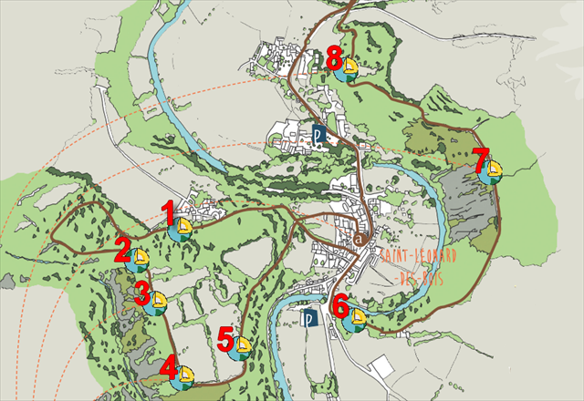
Cette série de 8 earthcachesest située sur le sentier intitulé "Histoires Géologiques". Chaque earthcache se trouve à l'emplacement d'un panneau informatif. Ce parcours vous permet de retracer 600 millions d'annéesd'histoire qui ont formé les roches et façonné le paysage. Le circuit, long de 10 kilomètres(3 heures environ), avec de forts dénivelés, est balisé et fléché en brun.
ATTENTION! Le parcours est fléché dans un seul sens, à l'inverse des aiguilles d'une montre. Les parkings et le point de départ du sentier sont indiqués en waypoints additionnels.
|
This series of 8 Earthcaches is on the trail entitled "Geological Stories". Each earthcache is located in the vicinity of an information board. This tour allows you to trace 600 million years of a history of geological events that formed the rocks and shaped the landscape. The circuit, 10 kilometers long (about 3 hours), with steep climbs, is marked and signposted in brown.
WATCH OUT! The tour is signposted in one direction, anticlockwise. Car parks and the starting point of the trail are in additional waypoints.
|
 |
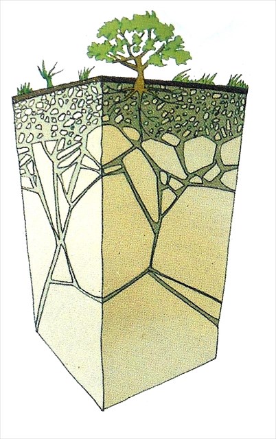
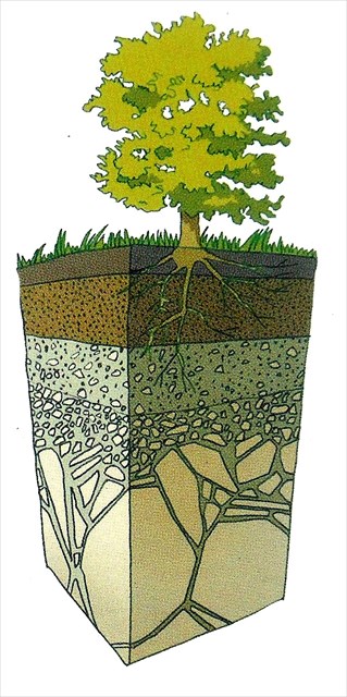
Une mince couche de sol, issue de l’altération de la croûte terrestre sous l’action des organismes vivants et des agents climatiques recouvre la plus grande partie des terres émergées. Elle est essentielle à la vie terrestre.
La formation d’un sol : la roche nue est fragmentée sous l’action des agents climatiques est d’abord colonisée par des lichens et des mousses ; la décomposition de ces premiers colonisateurs va créer les conditions de l’installation d’herbes et de petits arbustes plus exigeants en éléments nutritifs, qui a leur tour vont fragmenter la roche en enracinant et l’enrichir en se décomposant. Un sol « évolué » se forme après des milliers d’années d’altération de la roche-mère et de décomposition des organismes vivants.
Dans les Alpes mancellesalternent grès et schistes. Longtemps, sur le sol à nu des pentes recouvertes de grandes coulées de pierraille, la végétation peine à s’accrocher. En se décomposant, les grès donnent des sols très acides, les schistes des sols acides plus profonds et caillouteux. Sous l’ancien régime, les crêtes gréseuses incultes sont vouées au bois. Progressivement dégradés par la surexploitation, les bois sont peu à peu remplacés par des landes à bruyère. Les paysans les plus modestes y élèvent des moutons, seuls capables de se contenter de cette maigre végétation. Le milieu s’améliore vers le bas sur les pentes adoucies ; quand elles ne sont pas pierreuses et trop maigres pour être mises en valeur, elles donnent du seigle et du sarrasin. Mais les fonds de vallée, gorgés d’eau, restent impropres à la culture : la Vallée de la Misère porte bien son nom.
|
|
   |
|
A thin layer of soil on the Earth’s crust, resulting from the action of living organisms and weathering agents, cover most of the emerging land. It is essential to life on earth.
How soil is formed : exposed rock fragments under the action of weathering agents and was first colonised by lichens and mosses, as these first colonisers decomposed conditions were created for the survival of grasses and small shrubs that have more demanding nutritional needs. These, in turn, caused the rock to fragment further as their roots grew into it ; at the same time it became further enriched when they died and decomposed. An « evolved » soil formed after thousands of years of changes in the host of rock and decomposed living organisms.
In the Alpes Mancelles, sandstone and shale layers alternate. It took a long time for plants to establish on the bare soil on slopes covered with loose stone. As it broke down, the sandstone caused the soil to be very acid. Shale soil was acid too, deeper and stonier. Under the « Ancien Régime » (the time prior to establishment of the French Republic), uncultivated sandstone areas were covered with woodland. Gradually deteriorating through over exploitation, heath little by little replaced by woods. The poorest peasants raised sheep, the only animals able to survive on such poor grazing. The habitat improved on the lower, gentler slopes,so that areas where it wasn’t too stony or too poor for cultivation, were used for growing rye and buckwheat. But the valley bottom, liable to flooding, remainded unsuitable for cultivation, earning the name of the « Vallée de Misère ». |
Comment valider votre visite ?
Allez aux coordonnées indiquées au début de ce descriptif. Vous trouverez un panneau d'information. Afin de valider votre visite, vous devez répondre aux questions suivantes :
1) Quels est le nom des vers qui forent le grès ?
2) Les terrains escarpés de Saint-Léonard occupent une position géographique au point de contact de 2 zones géographiques, lesquelles ?
3) Comment des vers qui vivaient dans l'hémisphère sud ont-ils creusés des galeries dans les roches des pierriers de Saint-Léonard ?
4) OBLIGATOIRE : prenez une photo de vous, de votre GPS ou d’un objet personnel, à joindre avec votre log, avec la vallée en arrière-plan. (Guidelines des earthcaches du 10 juin 2019).
Envoyez vos réponses par mail ou messagerie geocaching. Inutile d'attendre ma validation pour logguer un "Found it", mais si vous oubliez de me fournir les réponses, votre log sera supprimé.
|
How to validate your visit !
Go to the coordinates indicated at the top of this page. Here you will find an information board. In order to validate your visit, you have to answer the following questions:
1) What is the name of that worm which dig into sandstone?
2) The steep terrain of St. Leonard occupy its position at the contact point of two geographical areas, which?
3) How worms living in the southern hemisphere have dug tunnels in the rocks scree of St. Leonard?
4) MANDATORY : take a picture of yourself, your GPSr or a personal object, to be attached with your log, with the valley in the background. (Earthcaches guidelines of June 10, 2019).
Send me your answers via mail or Geocaching Message Center (e-mail on my profile). You do not need to wait for my validation to log a "Found it" but if you forget to send me your answers, your log will be deleted.
|
|
|