
|
 |

|
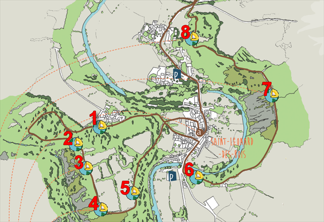
Cette série de 8 earthcachesest située sur le sentier intitulé "Histoires Géologiques". Chaque earthcache se trouve à l'emplacement d'un panneau informatif. Ce parcours vous permet de retracer 600 millions d'années d'histoire qui ont formé les roches et façonné le paysage. Le circuit, long de 10 kilomètres(3 heures environ), avec de forts dénivelés, est balisé et fléché en brun.
ATTENTION! Le parcours est fléché dans un seul sens, à l'inverse des aiguilles d'une montre. Les parkings et le point de départ du sentier sont indiqués en waypoints additionnels.
|
This series of 8 Earthcaches is on the trail entitled "Geological Stories". Each earthcache is located in the vicinity of an information board. This tour allows you to trace 600 million years of a history of geological events that formed the rocks and shaped the landscape. The circuit, 10 kilometers long (about 3 hours), with steep climbs, is marked and signposted in brown.
WATCH OUT! The tour is signposted in one direction, anticlockwise. The car parks and the starting point of the trail are in additional waypoints.
|
 |
Les roches les plus anciennes....
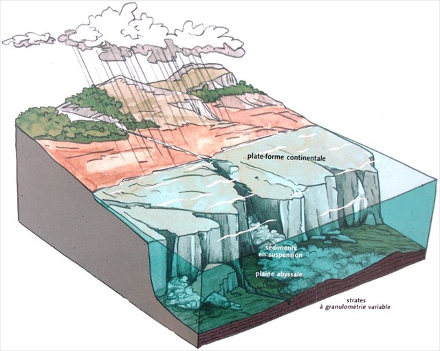
Les roches les plus anciennes de notre territoire datent du Briovérien, il y a près de 600 Ma. À cette époque, la région se trouve dans l'hémisphère sud, dans des eaux froides. De fines particules arrachées aux reliefs s'accumulent au fond de la mer. Lors de séismes, elles dévalent les pentes sous-marines et s'étalent dans une plaine abyssale. En suspension dans l'eau, les débris les plus lourds se déposent en premier, les particules les plus fines en dernier; ainsi se constituent des strates à granulométrie variable, phénomène que les géologues appellent le granuloclassement.
Ces sédiments vont subir des pressions dues à la formation successive de deux chaînes de montagnes - la chaîne cadomienne il y a 550 Ma, puis la chaîne hercynienne il y a 320 Ma - qui les métamorphiseront en schiste. Les bancs de schiste qui traversent le chemin présentent des strates dont l'épaisseur va de quelques millimètres au décimètre.
... venues du fond des mers profondes.
La série schisteuse constituée d'une alternance de couches de sédiments extrêmement fins - argilites/siltites et parfois quelques sables formant des grauwacques - est typique des grandes profondeurs comme celles des pentes allant du continent aux grands fonds marins (3000 m et +). Ainsi, le dépôt de sédiments qui a donné les schistes briovériens s'est fait dans une mer profonde, le Bassin Mancellien (Bassin du Maine).
|
|
|
|
The oldest rock...
The oldest local rock dates from the Brioverian Period, nearly 600 millions years ago. At that time, the region was in cold waters in the Southern Hemisphere. Fine particles worn away from higher ground accumulated on the sea bed. Earth tremors caused the undersea slopes to fall away sharply and the particles to become spread over an abyssal plain. In suspension in the water, the heaviest debris was deposited first, the finer particles subsequently. Thus strata with varying sized grains were constructed, a phenomenon the geologists call "graded bedding". The sediment was subject to pressure under the formation of two mountain chains - the Cadomian chain 550 million years ago, then the Hercynian chain 320 million years ago - which compressed it into shale. The banks of shale that cross the footpath have strata of varying thickness, from a few millimetres to a decimetre.
... from the deep sea bed
The shale series is made up of alternate layers of extremely fine sediment - argilite and silts with sand forming greywacke here and there. Greywacke is a grey, earthy rock typical of deep sea beds where the slopes go from the land to the deep seas (3,000 metres and more). The sediment deposits that produced Brioverian shale were made in deep seas of the Bassin mancellien (or Maine Basin).
|
| Banc de schiste sur le sentier |
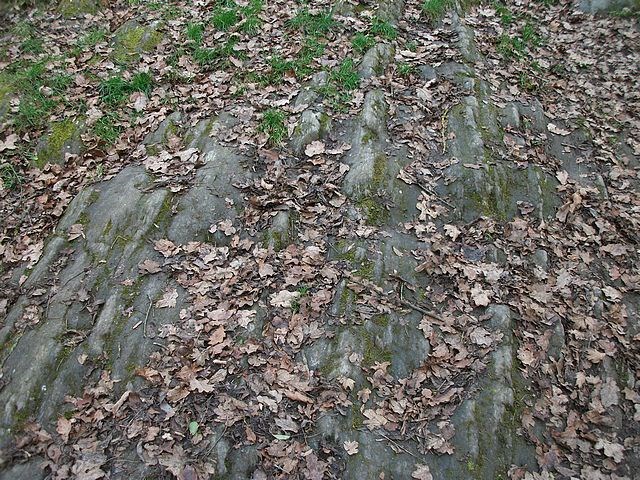 |
Bank of shale across the footpath |
Comment valider votre visite ?
Afin de valider votre visite, vous devez exécuter les tâches suivantes et répondre aux questions. Allez aux coordonnées indiquées au début de ce descriptif. Vous trouverez un panneau d'information.
1) Quel est le nom du méga-continent qui s'est fragmenté il y a 700 Ma ?
2) Quelle invention permet d'observer au jour le jour la dérive des continents ?
3) Allez au waypoint additionnel VS/VIRTST. Observez le banc de schiste briovérien au milieu du sentier. À l'aide de la boussole de votre GPS, indiquez l'orientation des strates de schiste (ex.: orientation E/W).
Facultatif: prenez une photo de vous et votre GPS au milieu du sentier.
Envoyez vos réponses soit par email (courriel sur mon profil) soit par le centre de messagerie Geocaching. Inutile d'attendre ma validation pour logger un "Found it", mais si vous oubliez de me fournir les réponses, votre log sera supprimé.
|
How to validate your visit ?
In order to validate your visit, you will have to perform the following tasks and answer the questions. Go to the coordinates indicated at the top of this page. Here you will find an information board.
1) What is the name of the supercontinent that broke apart 700 million years ago ?
2) What invention enables the continental drift to be observed in real time ?
3) Go to additional waypoint VS/VIRST. Have a close look at the bank of Brioverian shale in the middle of the footpath. Using the compass of your GPSr, give the orientation of the shale strata (eg. E/W orientation).
Optional: take a photo of yourself and your GPSr in the middle of the footpath.
Send me your answers either via private message (e-mail on my profile) or by using the Geocaching Message Center. You do not need to wait for my validation to log a "Found it" but if you forget to send me your answers, your log will be deleted.
|
|
|