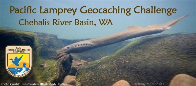
The Pacific Lamprey Geocaching Series will teach you some interesting facts about the Chehalis River Basin and the Pacific Lamprey found there. The Pacific Lamprey (Entosphenus tridentatus), relatively unknown and often underappreciated, is a declining species of fish that is a critical contributor to the fresh and saltwater ecosystems of the Pacific Northwest. These fish are also an important food and cultural resource for many Native American tribes. Threats to Pacific Lamprey include dams, stream degradation, poor water quality, and impacts of climate change. The U.S. Fish and Wildlife Service is working to restore Pacific Lamprey populations in collaboration with Native American tribes and other federal, state, and local agencies.
While there were pathtags for the first 75 cachers to complete the series, the real reward is learning more about the Pacific Lamprey, the Chehalis Basin, and the conservation entities working to restore these and other fish and wildlife populations. We hope that through this series you will develop a greater understanding of and appreciation for these “forgotten fish.”
What is the Pacific Lamprey Geocaching Series? - It is a series of six mystery caches located throughout the Chehalis River Basin. Solve the puzzles for these 6 caches, and then enjoy finding the cache at each location.
How to solve the puzzle and find the cache:
- There are two questions below, one for North coordinates and one for West coordinates.
- Use the provided web links to get the correct answer for each question.
- For the actual cache location use the coordinates given behind the correct answers.
- Find the cache using these coordinates and the hint.
- Park at the coordinates given below as a waypoint.
North coordinates question: What does a lamprey do when coming to a waterfall while going upstream? (for answer, visit link)
- Sucks on a salmon and hitches a ride over the falls = N 46° 39.136
- Uses its suction cup mouth to climb up the rocks at the waterfall = N 46° 39.087
- Gives up and goes back to the ocean = N 46° 39.167
- Jumps the falls like a salmon = N 46° 39.081
West coordinates question: Which of these is a traditional Chehalis tribe fishing location where the diminishing catch of Pacific Lamprey has been documented? (for answer, visit link)
- Wynoochee Falls = W 122° 59.028
- Spoon Creek Falls = W 122° 58.961
- Rainbow Falls = W 122° 59.058
- Deschutes Falls = W 122° 58.944
For a fascinating look at how the Pacific Lamprey is actually harvested please watch this video link.