The cache is placed on wooded Windmill Hill, just a quarter mile from the dead centre of the area covered by the map, and at 211m one of the highest points in the map area. The windmill no longer exists; apparently the only smock mill in Oxfordshire, it was burned down in 1912. From the top it had been possible to see the dome of St Pauls Cathedral in London, Windsor Castle and the Isle of Wight.
Sadly the nearby trig point was also destroyed more recently when the hill-top underground reservoir was constructed.
Each of the 171 caches you need to have found to qualify must be in a different British Ordnance Survey grid square as depicted on the Explorer 171 Chiltern Hills West map. These caches can be of any type, previous finds qualify (including those caches now archived and events attended - even if you were the host), in fact just about any cache other than those you have placed yourself can be counted.
For the purposes of this challenge the published co-ordinates of all caches, including Unknown/Mystery and Multi caches are the ones that are to be used when determining which square a cache is in.
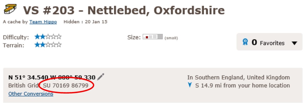
From personal experience I know how time consuming it is trying to determine which of the squares of any map a cache qualifies for, although of course the British Grid reference is given at the top of each cache page just below the main co-ordinates shown in bold, as circled below.
To help those of you who want to plan your finds (or check if you already qualify) a GSAK Macro has been written which produces a web page of your finds, as shown below.
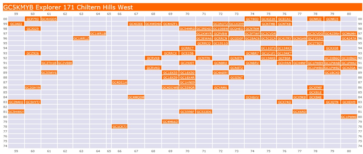
This is my own grid on day of publication of this cache.
When you have logged finds on the 171 caches plus, you need to provide proof of that fact to be eligible to claim a find on this cache; this can be in one of two ways:
- List the 171 cache codes and names in corresponding grid reference order in your found log (tedious and time consuming for you in compiling and me in checking, so not appreciated!)
- Add an image of the GSAK Macro generated file to your Found log
- If you don't use GSAK send us your "My Finds" Pocket Query before you log as Found and we will run the macro for you and let you know if you qualify, and if not which squares you still need to find a cache in to qualify
UPDATE JULY 2019 - please make sure you are using the latest (2019) macro, not the original, which no longer works.
Any Found logs submitted without proof of qualification will of course be deleted! Have fun!
To find out more about this and other Explorer Challenge caches, check this page, which has been created by PetersfieldPoodlePosse to complement the cache series. My thanks to them for the original Explorer Challenge idea, and for adding this cache to the GSAK Macro.
Please note that the Difficulty rating for this cache reflects the work required to obtain qualifying caches, the Terrain rating relates solely to this cache.
This cache contains one of four values,
all of which you will need to access this Challenge Bonus cache.
