You are standing on a sand bar of course! A very special sand bar because of the “natives” that like to visit, but that isn’t what an EarthCache is about. Check out the nearby virtual cache for those details. I hope you have a waterproof case for your iPhone!
The sea level here has been going up and down for at least 10,000,000 years since the Miocene Epoch. In fact, there is evidence that the sea level has changed and stabilized at least six time. We know that when the sea level drops due to a glacier forming and capturing seawater, a new shoreline is established at a lower level. When the glaciers melt, the water raises the sea level and a new shoreline is established at a higher level. When one of these shorelines is stable for a long enough time to erode into a beach zone, a wave-cut terrace can be formed. There are six well defined wave-cut terrace nearby.
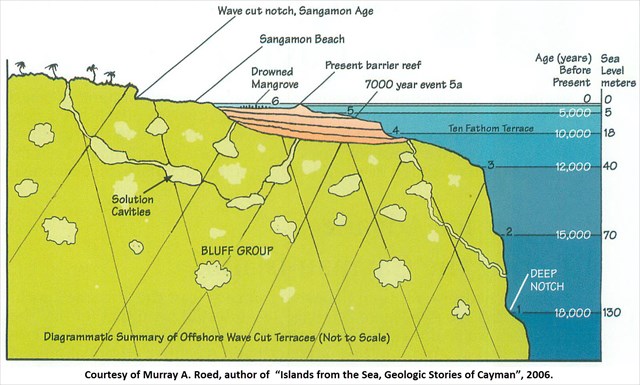
You are standing on the barrier reef BETWEEN the sixth wave cut terrace which is now the bottom of the North Sound and the fifth terrace which is about 5 meters (15 feet) deep that was formed approximately 7,000 years ago. A little bit farther from shore the bottom drops to a terrace (4th) at about 18 meters (54 feet). Beyond that, there is a terrace (3rd) at 40 meters (120 feet), 70 meters (210 feet) (2nd), and finally at the “Deep Notch” terrace (1st) at 130 meters (390 feet) which is estimated to have formed 18,000 years ago.
The North Sound here can also be defined as a Lagoon. When a body of water is cut off from the ocean, either completely or partially, it is called a Lagoon. The lagoon is formed when a reef separates it from the open ocean. The reef can be just submerged or just above the water and there may or may not be channels through it. Here, the barrier reef consists of a string of sandbars (which you are standing on) crossing the North Sound.
To claim this Earth Cache, please send me an email through my geocaching.com profile with answers to the following questions:
- What is the approximate difference (in feet or meters) of the 6th terrace to your south and the 5th terrace to your north?
- How many years was it between the formation of these terraces?
- Compare how the sea level changed between terrace # 1 (the Deep Notch) and terrace # 3 and how it changed beetween the 5th and 6th terraces. What do you think explains the differences?
- OPTIONAL Please post pictures!
- BONUS Estimate how many miles it is from where you are standing to the far side of the 6th terrace to the south (optional).
References
After reading many of the scientific papers on the geology of Grand Cayman, I stumbled across Murray Roed’s book Islands from the Sea, Geologic Stories of Cayman. I cannot emphasis enough how much more intuitive and clear my understanding of the geography became once I read Dr. Roed’s book. I picked up my copy at the little store near the post office in Hell.