FRANCAIS :
Les collines des environs de Mont-Saint-Eloi sont constituées d’une épaisse couche de craie datant de l’ère secondaire (sénonien et turonien supérieur). Elle a été formée par l’accumulation de squelettes d’organismes marins à l’époque où l’Artois était immergé sous une mer peu profonde. Elle contient de nombreux silex (roche sédimentaire sombre très dure) disposés en nodules ou en lits.
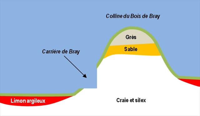
Cette craie a été protégée de l’érosion par les couches de grès (roche dure et imperméable) et de sable datant de l’ère tertiaire (landénien) encore présents au sommet.
Dans les vallées, la craie est recouverte par des limons argileux d’origine éolienne datant de l’ère quaternaire (pléistocène : - 2,6 millions d'années à -12 000 ans).
Au final, la craie n’affleure que le long des pentes des collines, où elle a été exploitée comme matériau de construction, notamment au niveau de la carrière de Bray, aujourd’hui aménagée en aire de piquenique.
Les coordonnées de la cache sont celles du parking de l’ancienne carrière de craie du hameau de Bray. Comme pour toutes les earthcaches, vous n'y trouverez pas de boîte. Pour valider votre découverte, répondez aux questions suivantes :
1 – Pour quelle raison la couche de grès a-t-elle protégé la craie de l’érosion ?
2 - A environ un mètre de la base du front de taille (R1), vous remarquerez une fine couche continue de silex séparant deux couches de craie. Quelle est son épaisseur ?
3 - Pensez vous que les pierres blanches utilisées pour construire la grange située de l’autre côté de la route (R2) ont été extraites de cette carrière ? Expliquez pourquoi (vous pouvez vous aider du panneau d’information).
Après avoir visité l'ensemble des points de référence, loguez cette earthcache "Found it" et envoyez-moi vos propositions de réponses soit via mon profil, soit via le Message Center. Je vous contacterai en cas de problème.
ENGLISH :
The hills around Mont-Saint- Eloi are made of a thick layer of chalk dating from the Mesozoic Era (Senonian and Upper Turonian). It was formed by the accumulation of skeletons of marine organisms when Artois was immersed under a shallow sea. It contains numerous flint nodules (very hard dark sedimentary rock).
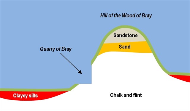
This chalk was protected from erosion by layers of sandstone (hard and waterproof rock) and sand dating from the Cenozoic Era (Landenian) still present at the top of the hill.
In the valleys, chalk is covered with clayey silts dating from the Quaternary period ( Pleistocene - 2.6 million years to 12,000 years).
Eventually, the chalk appears only along the slopes of hills, where she was extracted as a construction material, especially at the quarry of Bray, which is now a picnic area.
The coordinates of the cache are those of the parking of the quarry of Bray. As with all the earthcaches, you will not find a box here. To validate it, answer the following questions :
1 - Why the layer of stoneware protected the chalk against erosion ?
2 - In front of the rock face of the quarry (R1), you will notice at approximately one meter of the ground a thin continuous layer of flint separating two levels of chalk. What is its thickness ?
3 - Do you think the white stones used to build the barn on the other side of the road (R2) were extracted from this quarry ? Explain why (you can use the information board) .
After visiting all the reference points, you can log this earthcache as "Found it" and send me your answers via my profile or via the message center. I will contact you in case of problems.