EVENTO
MOINHOS DA CONDESSA
PORTUGUÊS

Este evento tem por objetivo dar a conhecer os Moinhos da Levada da Condessa, cuja construção data do Século XVI, as razões da sua construção e o que desta realidade histórica se pode ainda hoje observar.

PROGRAMA
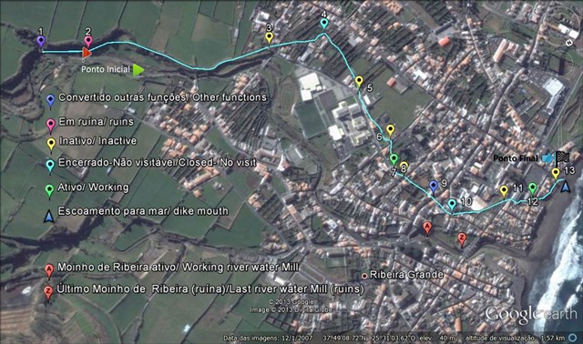
Se queres conhecer estes interessantes moinhos comparece pelas 10H00 do domingo, 1 de fevereiro, no GZ deste invento. Iremos percorrer a “Rota dos Moinhos”. Término do evento previsto para as 12H30.

NOTA HISTÓRICA
Desde o início do povoamento, que a Ribeira Grande se revelou um importante centro moageiro da Ilha de São Miguel. O triângulo Ponta Delgada, Lagoa e Ribeira Grande, extensa área produtora de cereais (trigo e milho), haveria de torná-la, até ao século XXI, ponto de procura para a sua transformação.
Logo a partir do século XV que, Moinhos de água para moagem daqueles cereais, foram instalados ao longo da ribeira e constituíam a grande riqueza da vila. Contudo, e de acordo com o cronista Gaspar Frutuoso, a erupção do Pico do Sapateiro, em 1563, hoje designado de Queimado, e já alvo também de uma multicache e uma earthcache, que recomendamos visitar, entupiu de cinzas e pedra-pomes a ribeira, então chamada de “ Ribeira dos Moinhos” o que, associado a uma enxurrada invernosa nesse mesmo ano, arruinou os Moinhos de ribeira da então Vila.
Na sequência deste desastre natural, depressa são construídos novos Moinhos, sem se saber ao certo quando, situados a distâncias irregulares e, desta vez, desviados do curso da ribeira, ao longo de uma canal artificial (levada), conhecida por “Vala” ou “Levada da Condessa”. Esta levada tem origem no açude da Ribeira Grande (Mãe de Água), divide as freguesias da Conceição e da Matriz e termina na Praia do Monte Verde, numa extensão de cerca de 2 Km. A levada era inicialmente um pouco mais longa já que, rezam as crónicas, a jusante da sua atual foz, existiu em tempos um Moinho, que foi destruído pelo mar. Os “Moinhos da Vala”, ou “da Condessa”, por certo por referência à proprietária maior dos terrenos por onde a levada foi construída, continuaram sob o monopólio do Capitão-do-donatário da Ilha de São Miguel, Conde da Ribeira Grande a partir de 1662, à semelhança dos de ribeira anteriormente destruídos, e chegaram a ser catorze, no total. Criada a Capitania Geral dos Açores, em 1766, o Conde perde o monopólio dos Moinhos. Porém, na prática a situação manter-se-ia, pelo menos, até ao período liberal e, inclusivamente em inícios do século XX, ainda se lhe pagavam foros.
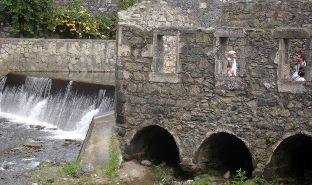
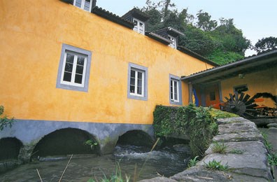
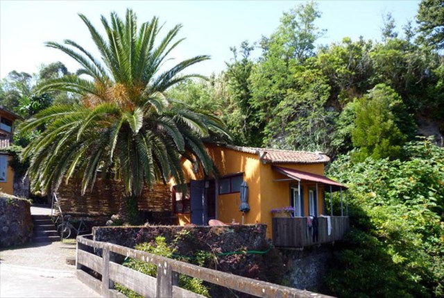
Deste conjunto de catorze “Moinhos da Condessa”, identificam-se hoje treze localizações e respetivos edifícios, uns em ruína, outros desativados, outros ainda adaptados a outras funções e dois ainda em funcionamento, com pelo menos um moinho propriamente dito eletrificado. Para melhor compreensão, vamos usar a palavra “Moinho” para o edifício e “moinho” para o conjunto formado pelas mós até ao rodízio.
A maioria dos Moinhos é de dois pisos, sendo o piso superior destinado à habitação do moleiro. No piso inferior situa-se a zona de moagem, tendo, em geral, quatro moinhos. Sob o piso das mós, abaixo da cota da rua, há ainda um meio piso, com arcos, onde se encontram os rodízios de penas utilizados para mover as mós. A água chega a cada moinho a um nível elevado e cai a pique sobre os mecanismos de moagem de modo a ganhar força para os mover. Escoa-se sob os arcos, passando geralmente por um fosso fronteiro antes de ser reconduzida à levada.

Não é sobre o número que encontrou.
É sobre a diversão que teve ao longo do caminho.
Os únicos números que importam são os amigos que você faz!
É tudo sobre a viagem, o desafio, e desfrutar do ar livre!

COUNTESS´ WATER MILLS
EVENT
ENGLISH

This event is intended to show the geocacher the Countess´s Water Mills and its dike, that started to be built in the XVI century, the reasons behind it and what still remains from this reality nowadays.
PROGRAM

If you want to know these interesting mills attending at 10:00 of Sunday, February 1, at the GZ. We will go through the "Route of the Mills". Event end at 12.30.

HISTORICAL NOTE
Since the beginning of settlement, Ribeira Grande has been proving to be an important milling center in São Miguel Island. The Ponta Delgada, Ribeira Grande and Lagoa geographic triangle, used to be a large production area of cereals (wheat and corn), and that has converted Ribeira Grande into a well demanded milling center, till the twenty-first century.
As early as the fifteenth century that water Mills for grinding cereals were installed along the river and contributed to the wealth of the village. However, according to the chronicler Gaspar Fructuoso, the eruption of Sapateiro Peak , in 1563, now designated Queimado, also a targeted multicache and a earthcache, that we recommend visiting, clogged the river with ash and pumice. The ash and pumice flow, combined with a wintry flood that same year, completely ruined the so called "Ribeira Mills".
Following this natural disaster, new Mills were quickly built, without knowing for sure when, located at irregular distances, and this time, away from the course of the river, along a man-made dike (levada), known as the "Ditch" or "The Countess´ levada." starts in the dam of Ribeira Grande (Mãe de Água), divides the parishes of Conceição and and Matriz and ends at Monte Verde beach, a stretch of about 2 Km. The dike was initially a bit longer, according to chronicles that state that a last Mill existed downstream from its present mouth. The sea had destroyed it unfortunately! The "Mills of the Ditch" or "of the Countess", named this way certainly by reference to the ownership of most of the land where the dike was built, like the river Mills previously destroyed, were under the continued monopoly of “Capitão-do-donatário”, a sort of Governor of the island of São Miguel, that became Count of Ribeira Grande in 1662. In total, they were fourteen, at a given time. Once created the Azores´s “Capitania Geral”, in 1766, the Count lost the monopoly of the Mills. However, in practice, the situation would remain pretty much the same, at least until the Liberal period of Portuguese History and even in the early twentieth century, taxes were still paid to him.
From the total set of fourteen "Countess´ WaterMills" we can still identify thirteen locations and their buildings, nowadays. Some are in ruins, others disabled, others even adapted to other functions and two of them still working , with at least one mill electrified. For better understanding, let's use the word "Mill" for the building and "mill" for the set formed by the grinding wheels and the rotation axe.
Most Mills have two floors, the top floor being the living floor for the owner or the worker(s) of the Mill . On the bottom floor is located the grinding zone usually fitted with four mills. All have a mezzanine floor below street level, with arches, where horizontal spur wheels, driven by the pressure of water, rotate the millstones. Water reaches every mill at a high level and falls over the grinding mechanisms in order to gain energy enough to rotate them. Then it flows under the arches, going usually through a front pool, before reentering the dike.
It's not about the number you've found. It's about the fun you had along the way. The only numbers that matter are the friends you make! It's all about the journey, the challenge, and enjoying the outdoors!