[Fi] Happamilla sulfaattimailla tarkoitetaan maaperässä luonnollisesti esiintyviä rikkipitoisia sedimenttejä (sulfidisedimenttejä). Niistä vapautuu hapettumisen seurauksena happamuutta ja metalleja maaperään ja vesistöihin. Happamat sulfaattimaat ovat savea, hiesua tai hienoa hietaa ja usein myös liejupitoisia.
Happamia sulfaattimaita esiintyy erityisesti muinaisen Litorina-meren korkeimman rannan alapuolisilla alueilla. Ne ovat nousseet kuivalle maalle maankohoamisen seurauksena.
 Happamia sulfaattimaita esiintyy Suomen rannikkoalueilla Pohjois-Suomen alueella noin 100 metrin ja Etelä-Suomessa noin 40 metrin korkeuskäyrän alapuolella. Nämä alavat, vanhan merenpohjan kerrostumat, ovat nykyisin viljelyskäytössä tai turpeen alla soiden pohjalla.
Rikkipitoisia sedimenttejä kerrostuu myös nykypäivänä mm. rannikon merenlahdissa ja jokisuistoissa, joista ne tulevaisuudessa kohonnevat kuivalle maalle ja kehittyvät happamiksi sulfaattimaiksi.
Happamien sulfaattimaiden maaperäprofiileissa esiintyy yleisesti sekä todellinen että potentiaalinen hapan sulfaattimaa.
Hapettomassa tilassa pohjavedenpinnan alapuolella sulfidisedimentit eivät aiheuta haittaa ympäristölleen ja täten näitä sedimenttejä kutsutaan potentiaalisiksi happamiksi sulfaattimaiksi. Maankohoamisen ja maankäytön kuten ojituksen ja maiden kuivatuksen myötä pohjaveden pinta laskee ja kyseiset kerrokset altistuvat hapettumiselle ja sitä kautta myös happamoitumiselle, jolloin niistä tulee todellisia happamia sulfaattimaita.
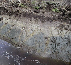
 Hapettumisen seurauksena sulfidikerrosten pH laskee keskimäärin arvosta 6-7 alle 4,5, paikoin jopa alle pH 3,5. Rikki esiintyy sulfaattimaissa tyypillisesti rautasulfideina, joista muodostuu hapettumisen seurauksena rikkihappoa. Hapettumisen seurauksena myös sulfidisedimentin väri muuttuu mustasta tai (tumman) harmaasta rusehtavaksi tai vaaleamman harmaaksi.
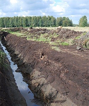
 Ohuen turvepeitteen alla aikaisemmin kuivatettu kerros, joka on hapettunut ja muuttunut harmaaksi, todelliseksi happamaksi sulfaattimaaksi ( pH 2.5–3). Uusi ojitus on paljastanut tummaa, alkuperäistä sulfidisedimenttiä (potentiaalinen hapan sulfaattimaa, pH 6–7), joka nyt hapettuu. Valumavesi on hapan (pH 3–4) ja metallirikas.
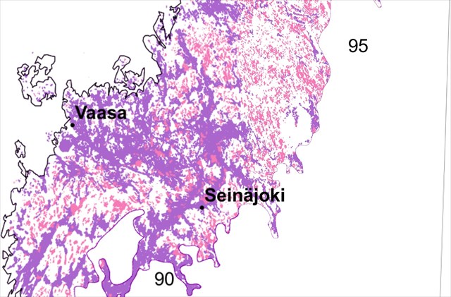
Kauhavanjoki kuuluu happamien sulfaattimaiden (vanha merenpohja) esiintymisalueeseen (kuvassa violetti alue), josta runsaiden sateiden ja maan muokkaamisen johdosta huuhtoutuu vesistöihin happamoittavia yhdisteitä ja niiden mukana liuenneita metalleja (esim. alumiini, kadmium, nikkeli). Joen vesi on alunapitoista. Alhainen pH vähentää vesieliöiden määrää ja haittaa esim. kalojen lisääntymistä.
Kauhavanjoen ajoittainen pH laskee alle 5 PH:n
Lokataksesi tämän kätkön sinun tulisi suunnistaa kätkön koordinaatteihin ja vastata seuraaviin kysymyksiin.
1. Kun olet koordinaattien osoittamassa paikassa, kerro mitä erilaisia kerroksia jalkojesi alla on ja kuinka paksuja, noin. Mikä on näiden eri kerrosten PH arvo, noin?
2. Tutustuttuasi kätkön kuvaukseen, mitä pitäisi tehdä, että tulevaisuudessa joen PH voitaisiin normalisoida?
3. Näet oikella sillan, joki on kaivautunut sillan kohdalla peruskallioon asti. Veden syvyys on normaaliaikana noin metri. Kun tarkkailet joen rantaa, kuinka paksusti (noin) meren pohjalle, peruskallion päälle, on happamia sedimenttejä kertynyt tällä kohdalla?
4. Vapaaehtoinen: voit ottaa kuvan itsestäsi tai GPS laitteestasi joki taustana.
Voit lokata kätkön löytyneeksi, lähetä vastauksesi profiilini kautta. Mikäli vastauksesi ovat täysin väärin, katsotaan mitä asialle voidaan tehdä..
------------------------------------------------------------------------------------
ESITE: "Happamat sulfaattimaat hallintaan"
Lähteet: Geologian tutkimuskeskus. Merigeologia ja globaalimuutos.
http://www.gtk.fi/tutkimus/tutkimusohjelmat
Kauhavanjoen ja sen ympäristön kehittäminen ja kunnostaminen - esiselvityshanke
--------------------------------------------------------------------------------------
Acid sulphate soils
[En]Acid sulphate soils are in soil naturally occurring sulfur-containing sediments (sulphide). Among them is released as a result of the oxidation, acidity and metals in soil and water. Acid sulfate soils are clay, silt or fine sand and often muddy.
Acid sulphate soils occur especially in the ancient Litorinasea beach, located below the highest areas. They have lifted up on the dry land due to land uplift.
[En] Acid sulphate soils are situated in the Finnish coastal areas, in northern Finland below about 100 meters and in southern Finland Below about 40 meters altitude. These low-lying, the old seabed, sediments are currently agricultural land or peat bogs throughout the background.
[En] Sulfur-rich sediments are making progres nowadays in coastal bays and estuaries, where they will rise up to the dry land and develop AS soils.
[En] Acid sulfate soils are commonly found in both the real and potential acid sulphate soils.
[En] The absence of oxygen, below the groundwaterlevel (water table), the sulphide-bearing do not cause harm to the environment, and thus these sediments are called as potential AS soils. Land uplift and land use, such as drainage and curing the land of, the groundwater level drops and the layers are exposed to oxidation and thus also to acidification, which become actual acid sulphate soils.
[En]Due to the Oxidation of the sulfid the pH drops to an average value of 6-7 less than 4.5, even below pH 3.5. The sulfur present in sulphate soils typically iron sulphide, which is formed by oxidation of sulfuric acid. By oxidation of the sulphide-bearing, color changes from black or (dark) gray to brownish or light gray.
[En] Thin peat over the previously dried layer, which is oxidized and turned gray, a true acid sulphate soils (pH 2.5-3). New drainage has revealed the dark soil, the original sulphide (potential acid sulphate soils, pH 6-7), which now is oxidized. Runoff water is acidic (pH 3-4) and metal-rich.
Kauhavanjoki [En] The River of Kauhava is situated in the area with acid sulphate soils (former seabed) (pictured purple area), where heavy rains and the editing of the leach water acidifying compounds and their associated dissolved metals (eg. Aluminum, cadmium, nickel). The river water consists aluna. The low pH reduces the amount of aquatic organisms and harms eg. fish reproduction.
The River of Kauhava's intermittent pH drops below 5 PH
To log this geocache, you will need to navigate to the cache coordinates and answer following questions
1. You are at the coordinates indicated, tell me, what different layers are there under your feet and how thick are they at this point. What is the PH-value of different layers, approximately?
2. Exploring the cache description, what should be done in the future to normalize the river PH to normal level?
3. On the right You can see the bridge, the river has dug itself until the bedrock. The water depth is normally about one meter. When you are watching the riverbank, how thickly (approximately) on the bottom of the ancient Litoriansea, on the bedrock is acidic sediments accumulated at this point?
4. Optional: You can take a picture of youself or your GPS device to the background of the river.
You may log this cache and then send the answers via my profile. I shall contact you via profile if there is a wrong answer.