One of the most famous rivers in all of America, leaves this country about a half a mile further into Mexico. But before it goes into Mexico, the river flows from east to west. It then makes a 90 degree turn to the south and flows into Mexico, which makes for some interesting geology lesson. Just before the Colorado River flows into Mexico, it makes a 90 degree turn here. if it didn't then this might have been the beginning of the US / Mexico border until it reached the Pacific. But there is some geology about this turn that is quite interesting. You can think of a river like wind. There are areas of high pressure and areas of low pressure. High pressure wind make rocks erode more quickly than low pressure wind. The same principles apply here. When the Colorado River is flowing in a near straight line, not one side favors the other in high or low pressures. When the river turns unexpectedly, things get interesting. This turn is called a bend or meander.

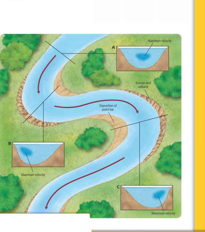
When the river turns to the right, there is high pressure on the left, which creates more drag and more erosion of sediments along the bank. Likewise, on the other side of the river, there is less pressure. So the water on the right side of the bend moves slower and sediment can be deposited along the bank. This makes the river move, over time, to the left.
When the river turns to the left, there is high pressure on the right. More water is hitting the bank at higher speeds than the left, so more sediment is taken by the river. Likewise, on the other side of the river, the water is moving much more slowly so sediment is being deposited. This will eventually make the river move to the right overtime.
High pressure means high velocity of water and low pressure means low velocity of water. The more velocity the river has on one side, means more erosion on the same side. The less velocity, means more will be deposited from tiny particles already being carried by the river. Where there is high pressure, it usually means larger particle size. This is due to the fact that the high pressure has to cut into new rock verses the other side which is only depositing already eroded material. On the low pressure side, you will likely see smaller, more fine particle size. You can think about this phenomena like a circular racetrack. The cars on the outer edges have to go faster and the cars on the inner edges have to go slower to match the speeds of the cars in the middle or the average speed of the cars.
Works Cited
http://www.briangwilliams.us/geology/visualizing-erosion-and-deposition-in-a-meander.html
http://study.com/academy/lesson/speed-and-velocity-difference-and-examples.html
TO LOG A FIND ON THIS CACHE YOU MUST GIVE ME THE CORECT ANSWERS BEFORE YOU LOG A FIND. YOU CAN CONTACT ME THROUGH MY EMAIL OR THE GEOCACHING MESSAGE CENTER. ANY INCORRECT ANSWERS WILL RESULT IN A DELETED LOG
1. Colorado River - Yuma on the first line of your email
2. Take a photo of you (or your signature item if you don't want your face to be shown) with the Colorado River in the background at the posted coordinates. This photo MUST be uploaded to your "found it" log. Please do not send any photos through the message center as Groundspeak compresses images. Each log MUST have a unique and different photo. No two logs may contain the same photo.
3. Describe the similarities and differences in sediment particle sizes from the California side verses the Arizona side AND your explanation as to why this might be. No need to swim across the river to find out.
4. Which side (AZ or CA) has the highest pressure or water velocity? Which side has the lowest?
5. Using the first diagram on this cache page, which option (A, B, or C) would best fit this section of the Colorado River when comparing water velocities?
6. Eventually, what direction will the river move to? In other words, what direction is the river cutting into? Consider what you see now will not change.
* NOTE - You will likely not receive an email back from me, unless I need clarification on your answers. Please, don't wait for me to tell you you have it correct or not. I do review your emails within 12 hours of getting them in my inbox and with other of my earthcaches, it has become too hard to do. As soon as you send the email, you can log this earthcache.