 Hatlamminsuo
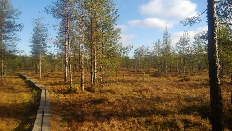
Riihimäen arvokkain yksittäinen luontokohde on luonnontilainen Hatlamminsuo. Se on kasvillisuustyypiltään rikas keidassuo, jossa laiteet ja keskusta erottuvat selvästi. Suon luonnonsuojelullinen arvo perustuu moniin eri suotyyppeihin, joita on kaikkiaan 40. Hatlammin pinta-ala on 61 ha, josta ojittamatonta aluetta on 47 hehtaaria.
Hatlamminsuohon liittyy kiinteästi Riihimäen korkein, geologisesti hyvin muodostunut moreenimäki, Hatlamminmäki. Mäen rinteessä on louhikkoinen vyöhyke, joka on muinaisen Yoldiameren rantavyöhyke.
Hatlamminsuo on keidassuo, joka on Etelä-Suomessa yleisin suotyyppi. Hatlamminsuo on syntynyt järven umpeenkasvusta. Muinaisjärven kuroutuminen itsenäiseksi järveksi Yoldiamerestä tapahtui yli 10 000 vuotta sitten. Vesistön syvänteet olivat jo mannerjäätikön sulamisvaiheessa täyttyneet hienoaineksella ja vedenpinnan taso oli kuroutumista seuranneessa vaiheessa todennäköisesti hyvin matalalla. Järven umpeenkasvun on otaksuttu tapahtuneen pian järven kuroutumisen jälkeen mesoliittisen kivikauden kuluessa, noin 8800 vuotta sitten.
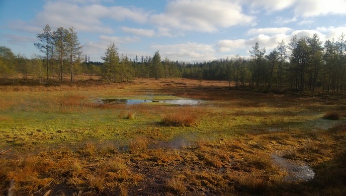
Hatlamminsuon keskustassa on jäljellä joitakin vesialueita eli allikoita. Valtaosin suo on mäntyvaltaista rämettä. Reunoilla on kuusivaltaisia korpia. Tällainen suo saa vettä pelkästään sateesta, joten alue on vähäravinteinen ja karu.
Keidassuo on niukkaravinteinen suo, joka on keskiosaltaan reuna-alueita korkeampi ja saa ravinteensa sadeveden mukana. Keidassuohon kuuluu erilaisia kasvillisuustyyppejä. Suon keskustan märissä painanteissa on lähes yhtenäinen rahkasammalpeite, jossa kasvaa tupasvillaa, mutasaraa ja suoleväkköä.
Keidassuon rakenne
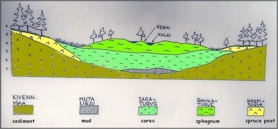
- Kermit on keitaan kuivempaa pintaa ja sillä on rämekasvillisuutta kuten puita ja varpuja
- Kuljut ovat kermien välissä matalammalla olevia vetisiä pintoja, joita peittää rahkasammal.
Näitä näet selvimmin Hatlamminsuon etelälaidalla.
- Allikot ovat vaihtelevan kokoisia. Hatlamminsuon keskustassa on useita allikoita, joista suurin on Hatlampi. Allikot ovat jäänteitä paikalla olleesta muinaisjärvestä.
Allikot ovat paikoin syviä ja jyrkkäreunaisia, joten niiden lähettyvillä liikuttaessa kannattaa olla erittäin varovainen!
Turve on osittain maatunutta kasviainesta, ja sen luokittelu perustuu siihen, mitä kasvityyppiä turpeessa on eniten. Suomessa esiintyvien turpeiden pääryhmät ovat rahkaturpeet (valtaosa rahkasammalta), saraturpeet (paljon saroja) ja puuvaltaiset turpeet (paljon puuainesta ja varpuja). Turve tuntuu jalan alla joustavalta ja pehmeältä.
Rahkasammalet ovat suomalaisen suon perusta. Ne kasvavat latvastaan kohti taivasta, ja samalla niiden alaosat kuolevat ja alkavat maatua. Suoveden hapettomissa ja happamissa olosuhteissa hajotus jää kesken, jolloin muodostuu turvetta. Ilman turvetta taas ei ole suota. Rahkasammalet myös osaltaan pitävät suon märkänä, koska niissä on paljon onttoja soluja, joihin voi varastoitua moninkertaisesti kasvin oman painon verran vettä!
Tehtävät
Logataksesi kätkön kierrä Hatlamminsuon 1 kilometrin mittainen luontopolku ja vastaa kysymyksiin.
1) Kun saavut Trail1 referenssipisteelle katsele ympärillesi ja kerro 3 asiaa mistä voit päätellä, että olet suoalueella.
2) Toisella referenssipisteellä on allikoita. Ota kämmenellesi vettä. Minkä väristä vesi on? Mistä väri tulee?
(Talvella tähän ei tarvitse vastata)
3) Miksi suot ovat niin tärkeä osa ekosysteemissä?
4) Kuinka kauan metrin paksuisen turvekerroksen kasvaminen kestää?
5) (vapaaehtoinen) Lisää kuva logiin.
Lähetä vastauksesi tekijälle ennen kuin loggaat löytösi. Älä paljasta vastauksia logissa. Sinun ei tarvitse odottaa loggauslupaa, mutta asiattomat loggaukset tullaan poistamaan.
 Hatlammibog
The most valuable nature site in Riihimäki is Hatlammibog which is in its natural state. The growth type of the swamp is a rich raised bog and you can clearly distinguish the centre and lag of the swamp. The Hatlammibog conservation value is based on the many different types of marshes and swamps which reaches up to a total of 40.The area of the Hatlamminsuo is 61 hectare of which 47 hectares is undrained.
Hatlammibog is closely linked to Riihimäki's highest, geologically well-formed moraine hill, Hatlamminmäki. The slope of the hill is a rocky zone and it's the shoreline of the ancient Yoldia Sea.
Hatlammibog is a raised bog type which is the most common type of bog in southern Finland.
The Hatlammi swamp is an overgrown ancient lake. Over 10 000 years ago the lake was separated to an independent lake from the Yoldia Sea. Due to the aggregation of the sediment in the basins during the melting of the glacial ice the water level of the basins was likely to be very low. Soon after the lake separated from the Yolida Sea the overgrowth started during the Mesolithic Stone Age about 8800 years ago.
In the center of Hatlamminsuo still remains some areas of water, shallow pools. Big part of the bog is dominated by pines. Along the edges spruce dominates.
Bogs occur where the water at the ground surface is acidic and low in nutrients. A bog is a mire that accumulates peat, a deposit of dead plant material—often mosses, and in a majority of cases, sphagnum moss.
The structure of a bog
- Kermit is covered with dry hummock and has bog vegetation such as trees and shrubs
- Hollows are lower parts between kermits and have watery surfaces, which are covered by spaghnum moss.
- The size of pools varies. In the center of Hatlammi bog there are several pools and the biggest pool is Hatlampi. Pools are relics from the ancient sea.
The pools are very deep and steep in places, you should be very careful when moving around!
Peat forms when plant material, usually in wet areas, is inhibited from decaying fully by acidic and anaerobic conditions. It is composed mainly of wetland vegetation: principally bog plants including mosses, sedges and shrubs. If you step on peat, it feels bouncy and soft.
Sphagnum mosses are the foundation of the mire. They grow from apex to the sky and same time the lower parts die and begin to decompose. Under low oxygen and acidic conditions decomposition is incomplete, thereby peat is formed. Without the turf there is no mire. Peat mosses also contribute to keep the moss wet, because they have a lot of hollow cells, which can store many times the plant's own weight of water!
Your task
In order to log this EarthCache as found you need to fulfil the following tasks:
1) At reference point Trail1. Look around, how can you tell that you are in the swamp area. Mention three things.
2) At reference point 2 there are pools. Take water in the palm of your hand. What color is it? Where does the color come from? (In winter you can skip this question)
3) Why peatlands have so important role in the global ecosystem?
4) How long does it take to grow 1 meter thick peat layer?
5) (optional) Add a picture to log but don't revial answers.
Please send the answers to the cache owner via profile before you log this cache.
You don't have to wait for a logging permission, but any incomplete logs will be deleted.
Lähteet/Sources: Riihimäen kaupunki : riihimaki.fi
geologia.fi
luontoliitto
wikipedia