The west coast of India is traversed by number of faults. One major fault which runs parallel to the coast is known as West Coast Fault (WCF). The tectonic features aligned parallel to the continental margin of India were formed during northward drift of Indian plate and those traversing across the margin were formed before the drift. The pre-drift tectonic features, running across the WCF, were formed during Jurassic/Cretaceous and Tertiary period.
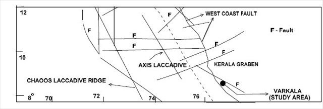
Regional Tectonic map of study area (modified from Chandrasekharam, 2001)
Varkala beach shown on the map is a major tourist destination, which attracts a large number of foreign and domestic tourists. The beach is narrow and a 30 m cliff stands immediately to the east. The cliff section, named North Cliff runs parallel to the coast line over a kilometre. The cliff exposes the litho units of Tertiary and Recent. The cliff section at Varkala is consisting of clay, lignite band, sandy-clay, sandstone of Mio-Pliocene age. This sedimentary sequence is overlain by a thick laterite (see below figure).
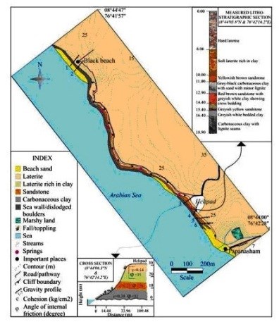
Varkala is the only place in southern Kerala where cliffs are found adjacent to the Arabian Sea. This cliff formation is a unique geological feature on the otherwise flat Kerala coast, and is known among geologists as Varkala Formation. There are numerous water spouts and spas on the sides of these cliffs. The Geological Survey of India is in the process of getting it declared as a 'geological monument’. The formation shall be the 27th geological monument of India.
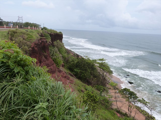
The cliff formation is slowly receding landwards as it is experiencing severe denudation. Marine erosion processes attack the foot of the cliff and cause the erosion at a wave cut notch. Waves can pound this area causing fragments to break off, and the water can also trap air in pore spaces, faults and crevices, compressing the air which in turn exerts pressure on the rock causing it to break off. This process is known as hydraulic action. Another process that occurs is corrosion, where sediment and rocks in the sea water are hurled against the cliff face. All three of these processes erode the wave cut notch at the base of the cliff undermining the whole structure of the cliff. These processes are variable and depend upon the fetch of the wave (the distance it travels over open water), wind speed and how many storms there a year.
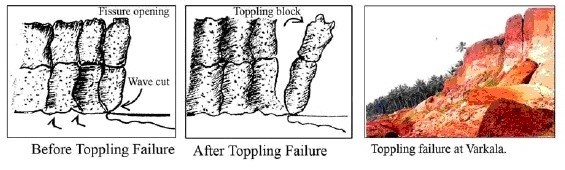
Varkala often witness landslides in the form of fall, toppling and debris slides. Fall and toppling are initiated by tension cracks. Presence of tension cracks facilitates water percolation and hence an exertion of hydrostatic force which ultimately lowers the factor of safety. Usually the top laterites are more prone to fall and topple and such boulders are seen along the slope off the cliff.
Debris slides occur mainly due to undercutting by wave action.
To log this earthcache as a found
you have to send the answers to the following questions via GC profile BEFORE online logging. Please log directly afterwards without waiting for log permission, we will contact you if there will be something sincerely wrong.
Logs not accompanied by email the same day will be deleted per earthcache rules. I don't like doing that. But you need to complete the requirements. The questions are not difficult and are designed so that anyone can fulfill them.
1. In which months do you think the waves are getting closer to the cliffs? Please explain?
2. Based on your observations at Ground Zero. Which of the sediments you think will is the major geological factor that is causing wave undercutting as well over-hang collapse?
3. What do you think the top laterites boulders fallen down on the beach can reduce? Please explain?
4. We would be glad if you could upload a photo of the beautiful beach and formations but is only optional !!
sources:
Wikipedia
Engineering Geology for Society and Territory - Volume 2 - Landslides processes
Geological Survey of India (GSI)