FRANÇAIS :
Préparez-vous à découvrir une destination authentique et d’une grande diversité. Des plaines à niaoulis des espaces de l’ouest aux cascades noyées de verdure de la côte est et de la chaîne centrale, en passant par les collines arides du Grand Nord, les îlots et les plages désertes, la terre rouge du pays minier, le Nord calédonien a bien des choses à partager avec vous : une nature magnifique, une histoire riche, une biodiversité exceptionnelle, un lagon inscrit par l’Unesco au patrimoine mondial de l’humanité, une population multicolore au caractère bien trempé…
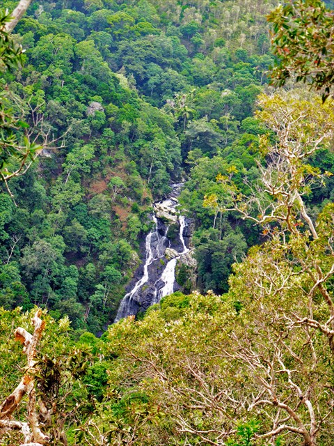
Cache N°5 : Sentier Bweö
Sur la route du col des Roussettes, qui relie Bourail à Houaïlou, en plein cœur de la chaîne centrale, la tribu de Boréaré offre la possibilité d’une randonnée pédestre étonnante et sportive, entre découverte botanique, vestiges archéologiques et paysages à couper le souffle…
En suivant votre guide Jean-François Gowe le long des 10 km de sentier, vous traverserez successivement une forêt de pinus, une savane à niaoulis et la grande forêt humide, vous cheminerez le long de la rivière Wa Bwea (baignade conseillée !) et jouirez d’un point de vue sur la cascade toute proche. Dans la forêt humide, vous découvrirez le Chambeyronia, palmier endémique aux feuilles rouges et apercevrez peut-être des cerfs. Plus loin, vous découvrirez les vestiges d’anciennes cases et des pétroglyphes, mystérieux messages gravés dans la pierre par les Anciens.
À la descente du col des Roussettes, direction Houaïlou, bifurquez à droite avant le pont bleu (premier Waypoint) vers la tribu de Cala, puis prenez à droite à la patte d’oie jusqu’au temple (second Waypoint) où vous pourrez garer votre voiture. Le départ du sentier se situe aux « trois manguiers » à 800 m du temple en remontant vers l’entrée de la tribu (troisième Waypoint). L’accès du premier tronçon jusqu’à la cache est en accès libre. En revanche, la randonnée complète est obligatoirement guidée, le sentier n’étant pas balisé. Contacter Jean-François Gowe au 42 59 54, 42 48 59 ou 81 14 22 (ne pas hésiter à laisser un message).
Prévoyez les indispensables du randonneur (chapeau, chaussures fermées, réserve d’eau…).
Apportez votre propre crayon. Avant de repartir, merci de bien re-cacher la boîte, pour le plaisir du prochain géocacheur !
ENGLISH:
Get ready to explore an unusually diverse and authentic destination. From the niaouli plains of the open West Coast to the greenery-shrouded waterfalls of the East Coast and the central mountain chain, from the arid hills of the Far North to the islets, deserted beaches and red earth of the mining country, the North of New Caledonia has much to share with you: a magnificent natural environment, a rich history, exceptional biodiversity, a lagoon listed by UNESCO as part of the World Heritage, a rainbow-coloured population with a sturdy character…
Cache No 5: Bweö track
On the Col des Roussettes road linking Bourail to Houaïlou, in the very heart of the mountain chain, Boréaré tribal village offers an astonishing and athletic hike, including botanical exploration, archaeological remains and breathtaking scenery...
Following your guide Jean-François Gowe along the 10 km track, you will pass in turn through a pine forest, a niaouli savannah and the great rainforest before walking along the Wa Bwea river (a swim is recommended!) and enjoying a lookout over a nearby waterfall. In the rainforest, you will see the blushing palm (Chambeyronia macrocarpa), an endemic palm with red leaves, and may spot deer. Further on, you will find the remains of old traditional huts and petroglyphs, mysterious messages engraved in stone by the Elders.
Coming down the Col des Roussettes, towards Houaïlou, take the right fork before the blue bridge (first Waypoint) towards Cala tribal village, then turn right at the junction and continue as far as the Protestant church (second Waypoint) where you can park your car. The track starts at the “three mango trees”, 800 m from the church up near the entrance to the tribal village (third Waypoint). Access to the first section as far as the cache is open to all. On the other hand, the complete hike must be done with a guide as the track is not marked. Contact Jean-François Gowe on 42 59 54, 42 48 59 or 81 14 22 (don’t hesitate to leave a message).
Make sure you take the hiker’s essentials (hat, closed-toe shoes, water supply, etc.).
Bring your own pencil.
Before setting off, please hide the box again, so the next geocacher has the fun of finding it!