EarthCaches are cool, just think and cache them!
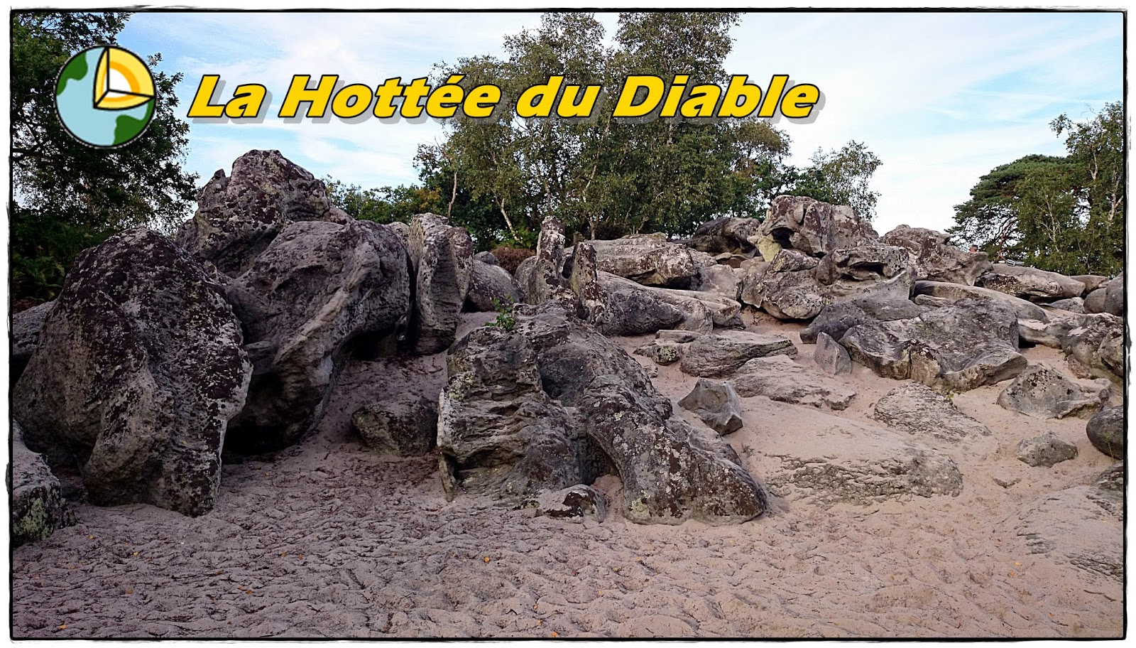
 Située au cœur du Pays du Tardenois, la Hottée du Diable est constituée de bois et d'une butte sableuse parsemée d'énormes blocs de grès et de lande sèche.
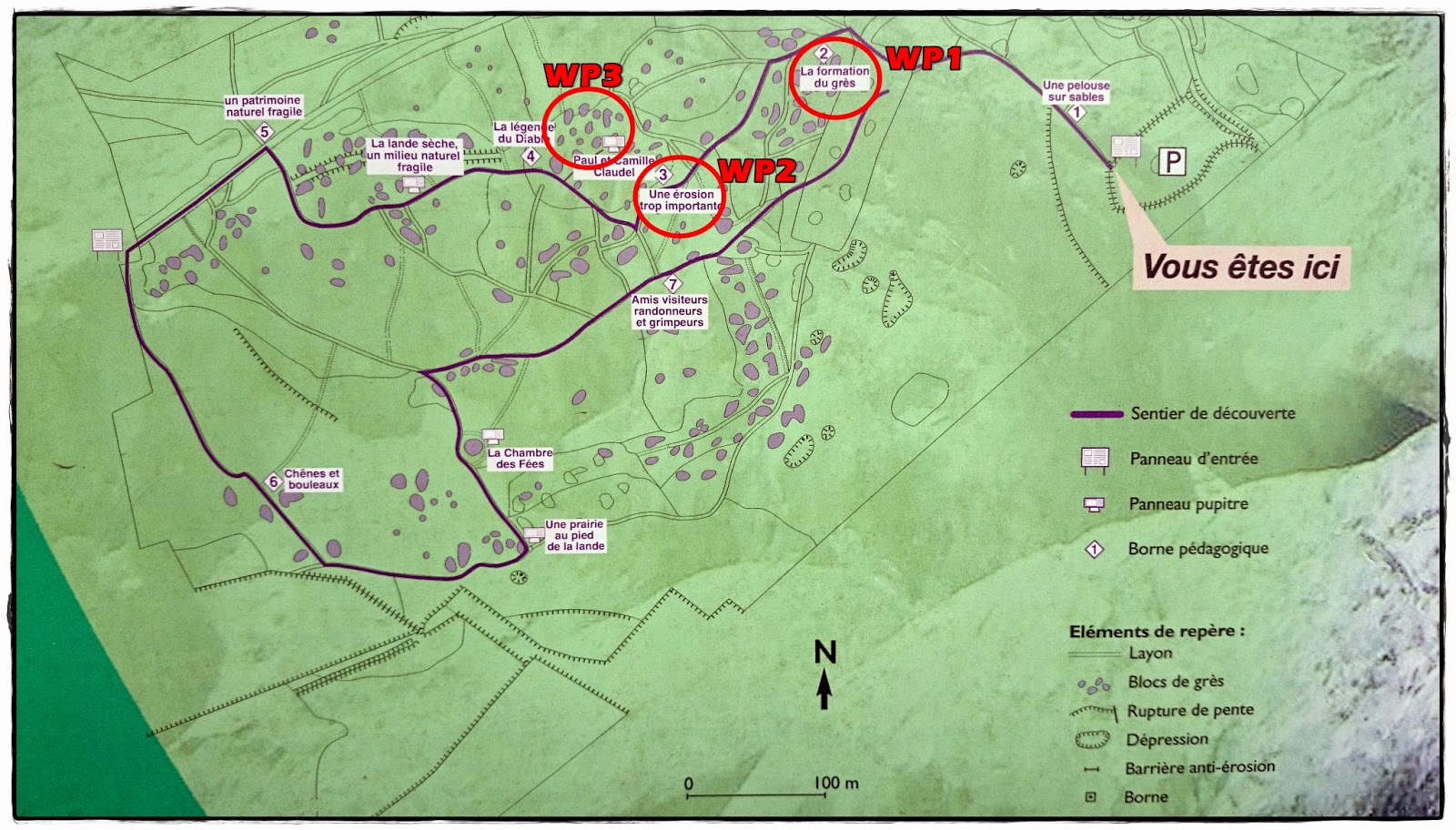
Après vous être garés sur le parking disponible de cette Earthcache, vous pouvez regarder le panneau d'information qui se trouve sur le parking et suivre le
parcours qui vous guidera au waypoint 3 de la cache tout en faisant le parcours pour répondre aux questions.
Attention : Ce lieu est protégé, veuillez ne pas enjamber les barrières qui délimitent des zones où la végétation est fragile. Si vous avez la chance comme moi, vous pourrez voir un spécimen de lézard vert.
Définition du grès:
Le grès est une roche détritique, issue de l’agrégation et la cimentation (ou diagenèse) de grains de sable. Il peut s'agir d'une roche cohérente et dure. Ces grains sont souvent composés de silice (et parfois même de grains de feldspath et de micas noirs), mais ils peuvent avoir d’autres compositions. On parle alors plutôt d'arénite, en particulier si les grains sont carbonatés.
Formation du grès:
La cimentation des grains se fait par précipitation et cristallisation des sels dissous dans l’eau interstitielle, on appelle ce processus la « grésification ». Les grains, et le ciment entre ces grains peuvent avoir une composition différente selon l’origine et l’histoire de ce grès. Les dépôts successifs de sable se retrouvent dans la stratification du grès. La roche prend des couleurs différentes en fonction de la présence d'oxyde de fer.
L’affleurement des roches sédimentaires:
Les roches sédimentaires sont portées en surface dans le cadre des grands mouvements tectoniques qui affectent l'écorce terrestre. Le choc des plaques continentales a entraîné l'émergence des fonds marins, qui apparaissent, aujourd'hui, sous forme de bassins ou de formations d'altitude. Lors de ces mouvements tectoniques, ces roches ont pu être soumises, localement, à des pressions très fortes et à de très hautes températures. Il en est résulté une transformation de ces roches en roches métamorphiques. Les calcaires se métamorphisent en marbres et les argiles en schistes, voire en gneiss.

Rappel concernant les « Earthcaches »: Il n'y a pas de conteneur à rechercher ni de logbook à renseigner. Il suffit de se rendre sur les lieux et d'exécuter les requêtes du propriétaire de la cache (l'envoi d'un mail pour validation). BON GEOCACHING!!!
Pour valider votre visite:
1-. Au WP1, cherchez la plaque et complétez la phrase "La circulation de l'eau chargée de ... "
2-. Au WP1, combien de dessins voyez-vous sur la plaque ?
3-. Direction au WP2, à l'aide de cette plaque, expliquez pourquoi y a-t-il une érosion si importante.
4-. WP3, à quelle hauteur êtes-vous dans cet endroit?
 Located in the heart of the Tardenois Country, the Hottée du Diable is made of a forest and a sandy hill dotted with huge blocks of sandstone and lavander.
After you have parked in the parking lot available at this Earthcache, you can watch the notice board located in the parking lot and follow the path that will guide you to the waypoint 4 of the cache while doing the tour to answer the questions.
Warning: This place is protected, please do not step over the boundaries that separate areas where vegetation is fragile. If you're lucky like I was, you will see a green lizard specimen.
Located in the heart of the Tardenois Country, the Hottée du Diable is made of a forest and a sandy hill dotted with huge blocks of sandstone and lavander.
After you have parked in the parking lot available at this Earthcache, you can watch the notice board located in the parking lot and follow the path that will guide you to the waypoint 4 of the cache while doing the tour to answer the questions.
Warning: This place is protected, please do not step over the boundaries that separate areas where vegetation is fragile. If you're lucky like I was, you will see a green lizard specimen.
Definition of sandstone:
Sandstone is a clastic rock, result of the aggregation and cementation (or diagenesis) of sand grains. It may be a coherent, hard rock. These grains are usually composed of silica (and sometimes feldspar grains and black mica), but they can have other compositions. It is called arenite, especially if grains are carbonate.
Formation of sandstone:
The cementing of grains is done by precipitation and crystallization of salts dissolved in the pore water, this process is called "grésification". Grains, and cement between grains may have a different composition depending on the origin and history of this sandstone. Successive sand deposits are found in stratified sandstone. The rock takes different colors depending on the presence of iron oxide.
The outcrop of sedimentary rocks:
Sedimentary rocks are brought to the surface within the major tectonic movements that affect the Earth's crust. Clash of continental plates led to the emergence of the seabed, which appear today in the form of tanks or altitude formations. When these tectonic movements, these rocks have been submitted locally at very high pressures and high temperatures. This resulted in a transformation of these rocks into metamorphic rocks. The limestone métamorphosed into marble and clay into shales or gneiss.
Reminder on "Earthcaches": There is no container or logbook on the given coordinates. Just visit the site and answer the questions by e-mail. There is no need to wait for my reply, feel free to log immediately after. If the answers are incorrect, I will let you know. Happy caching!
To validate your visit:
1-. At WP1, find the plaque and complete the sentence "La circulation de l'eau chargée de ... "
2-. At WP1, how many drawings can you see on the plaque?
3-. WP2. With the help of the plaque, explain why there was such an an important erosion.
4-. WP3, what is the height in there?
Sources: Conservatoire des sites Naturels et Geologics de la Picardie.