
Domo Vitrofírico Piedra Parada

En el centro de la estepa patagónica, en la Provincia de Chubut, existe una imponente mole de piedra que formaba parte de un volcan extinto antes de que los Andes fueran creados por sucesivos solevantamientos de las placas tectónicas, y que hoy desafía los sentidos del viajero con su enigmática presencia, se trata del Domo Vitrofírico Piedra Parada, una formación rocosa de 285 mts de altura, enclavada en una de las márgenes del Rio Chubut.
Para llegar a Piedra Parada, se deben recorrer 17 kilómetros desde la ciudad de Esquel por Ruta Nacional Nº 40, tomando luego la Ruta Provincial Nº 12 para llegar a la población de Gualjaina a 65 kilómetros por un bien conservado camino de ripio. Finalmente llegamos a la zona conocida como Cañadón de la Buitrera, donde está situada la extraña roca. Pinturas rupestres, puntas de flechas y restos fosilizados pueden ser encontrados en el área, sumándole un atractivo extra a la zona.
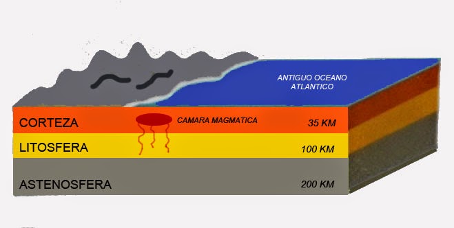
La historia de esta piedra comenzó hace sesenta millones de años, cuando se formó una cámara o reservoreo magmático cercano a la superficie de la tierra, en la periferia de un oceano de poca profundidad, existente en esta zona,
In the middle of the grasslands of Chubut, there is a giant rock formation that was part of an extinct volcano that was formed before the Andes were created by the successive upheavals of tectonic plates. Today it challenges the senses of travelers with its enigmatic prescence, it is called Domo Vitrofírico Piedra Parada (Standing Rock), a formation that reaches 285 meters high, located on one of the banks of the Chubut river.
To reach Piedra Parada, drive 17 kilometers from the city of Esquel on National Route 40, then take Provincial Highway No. 12 for 65 km on a well maintained gravel road, to reach the town of Gualjaina. Finally, you will arrive at an area known as Cañadón Buitrera where this enormous rock is located. Cave paintings, arrowheads and fossilized remains can also be found here, adding extra adventure to your excursion.
The history of this stone tower began sixty million years ago, when a wall cavity with a magmatic reserve near the surface of the earth was formed near a shallow ocean, that existed in this area.
The history of this stone began sixty million years ago, when a wall cavity with magmatic reserve near the surface of the earth was formed in the periphery of a shallow ocean, already existing in this area.
Millones de años despues, se produjo una gran erupción volcánica con salida de gran cantidad de lava, cenizas, rocas y gases, en forma de columna y pluma piroclástica que se derramaron en forma de flujos calientes por la pendiente del terreno.
Millions of years later, there was a large volcanic eruption with a lot of ash, rock, and gas, that spilled hot rivers of lava down its slope and formed what is known as a cilinder cone.

La salida de tal cantidad de lava, provoca el vaciamiento de la cámara bajo el volcán, lo que sumado al peso del material acumulado en la superficie, hace que el techo de esa cámara magmática colapse y se forme una depresión de forma circular (caldera) y de un tamaño considerable, que en este caso alcanza los 25 km de diámetro, con paredes verticales compuestas principalmente por los materiales emitidos por el volcan en la primera etapa, Esta depresión paulatinamente se va llenando con material piroclastico que cae de la columna. La formación de calderas es un ejemplo visible de la actividad del magma en la superficie de la tierra.
The output of such a large quantity of lava caused the emptying of the lava chamber under the volcano, which added to the weight of the material collecting on the surface, which made the roof of the magma chamber collapse, forming a circular depression called a caldera. The caldera measures 25 km in diameter, with vertical walls composed mainly of materials from the volcano from the first stage of the eruption. The depression gradually filled with pyroclastic material falling from the column. Calderas form a visible example of the activity of magma in the surface of the earth.
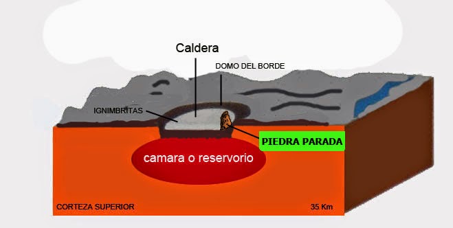
Lo que hoy conocemos como Domo Vitrofírico Piedra Parada, es un domo de lava , también conocido como domo tapón, que es un montículo de forma circular que se origina en una erupción lenta de lava viscosa en el borde de la caldera. La viscosidad de la lava, no permite que esta fluya demasiado lejos de su chimenea antes de enfriarse y solidificarse convirtiéndose en roca dura
Hace treinta y cinco millones de años, el domo, tenía una altura diez veces superior a la actual, es decir entre 2600 y 2700 mts. Posteriormente, hacia el final de la última era glaciar, hace aproximadamente diez mil años, la encontramos rodeada por las aguas de un gigantesco río (el actual Rio Chubut) que tenia un caudal muy superior al del presente y cuyas aguas desgastaron todo el material sedimentario, mas blando, que la rodeaba, dejándola aislada en la posición que hoy la observamos.
What we know today as Domo Vitrofírico Piedra Parada, is a “lava dome” or “dome cap”, which is a circular mound that originates in a slow eruption of liquid lava on the edge of a caldera. The viscosity of the lava, does not allow it to flow too far from its opening before cooling and solidifying and becoming hard rock.
Thirty-five million years ago, the dome had a height ten times the current height, between 2600 and 2700 meters. About ten thousand years ago, towards the end of the last ice age, it found itself surrounded by the waters of a giant river (now Chubut River) which had a much higher flow than now, and whose waters eroded the softer sedimentary material around it, leaving it standing alone in the position that we see it today.
Para registrar el caché deberá pararse frente al cartel informativo presente en el lugar para responder las siguientes preguntas por medio de un correo a fhsosa@telecentro.com.ar :
-
Cual es el origen de las rocas de color blanquecino presentes en el lateral del domo y en el cerro que aparece detras del mismo, hacia la izquierda, vistos desde su posición ?
-
Como se denomina la roca que forma principalmente el domo?
-
Desde su posición, busque otro Domo Riolítico y compare textura, color y composición con la "Piedra Parada". Una vez localizado y tomando en cuenta que los domos indican el borde de la caldera original, indique si el Rio Chubut corre dentro o fuera de la misma.
- ***Bonus*** (pero no es un requisito) pero puede ser útil si sus respuestas anteriores no son correctas, para una verificación adicional y para evitar los logs falsos, en su registro, por favor, incluya una foto de su grupo con el GPS en el sitio del caché.
AVISO: Todos aquellos registros que no cumplan los requisitos, serán eliminados.
To log the cache you must stand before the information sign on site to answer the following questions by email to fhsosa@telecentro.com.ar::
-
Origin of whitish rocks present on the side of the dome and on the hill that appears behind the same, left, seen from your position?
-
As is known primarily rock form the dome?
-
From your position, look for another ryolitic dome and compare the texture, color and composition of it to the "piedra parada". Once you find it, take into account that the domes indicate the edge of the original boiler, indicate whether the Rio Chubut runs in or outside of it.
- ***Bonus*** (not required) - But it may be helpful if your answers above were incorrect. (For additional verification to avoid phony logs) - In your log please include a picture of your group with your gps at the cache site.
NOTICE: All the logs not accomplishing the requeriments, will be deleted.

Fuentes:
- Centro de Investigaciones Geológicas (UNLP-CONICET). 1 Nº 644. (1900) La Plata, Buenos Aires. Argentina.earagon@cig.museo.unlp.edu.ar
- Aragón, E. y Mazzoni, M., 1997. Geología y estratigrafía del complejo volcánico piroclástico del río Chubut medio (Eoceno), Chubut, Argentina. Revista de la Asociación Geológica Argentina
- Petersen, C., 1946. Estudios geológicos en la región del Río Chubut Medio. Dirección General de Minas y Geología, Boletín 59: 137 pp. Buenos Aires
Agradecimientos:
Se agradece en especial la colaboración prestada para la traducción al inglés y las sugerencias, de los siguientes Geocachers, los que indudablemente han contribuido a mejorar la claridad de ideas expresadas en el mismo.
Acknowledgments:
Their collaboration for the translation into English and suggestions, the following Geocachers Special thanks, which have undoubtedly helped improve the clarity of ideas expressed therein.


 Felicitaciones grinpol por ser el primero en completar los requisitos !!