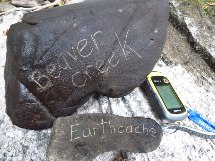
BEAVER CREEK FIDDLAR RAPIDS EARTHCACHE
(A Comparative Analysis of Glacial Erosion and Flood/River Water Erosion)
As of 2020, it is not feasible to access the Earthcache location from the bridge on Beaver Creek Road. Therefore you will need to paddle up, 6 kilometres, from the south, from Mag's Landing Boat Launch in Marmora. It's a long 6 kms, so leave yourself lots of time. When you reach the bottom of the rapids, you will run out of water. I have left you coordinates for where you can leave your kayak on the grass (the east side is where we ditch our canoe), and walk up 50 metres to the posted coordinates. Cheers!
Boat launch and free parking : Marmora Mag's Landing Boat Launch, Cordova Road, on the Crowe River. There is ample parking and a portable toilet. It is about 2 kilometres from the boat launch to the entrance to Beaver Creek and another 4 kilometres up Beaver Creek to the south end of Fiddlar's Rapids. July, August, and September seem to be good months for accessing the rapids easily.
Background Information:
Beaver Creek is a river flowing south from Limerick Lake, near Bancroft, to the Crowe River in Marmora. The river lies predominantly in the rugged Canadian Shield where outcrops of granite and other Precambrian rocks are located at or near the surface.
The Precambrian Era is the most ancient of all earth's historical periods and dates back to the very formation of the world as we know it. The rocks at this Earthcache, therefore, could be as old as the earth itself.
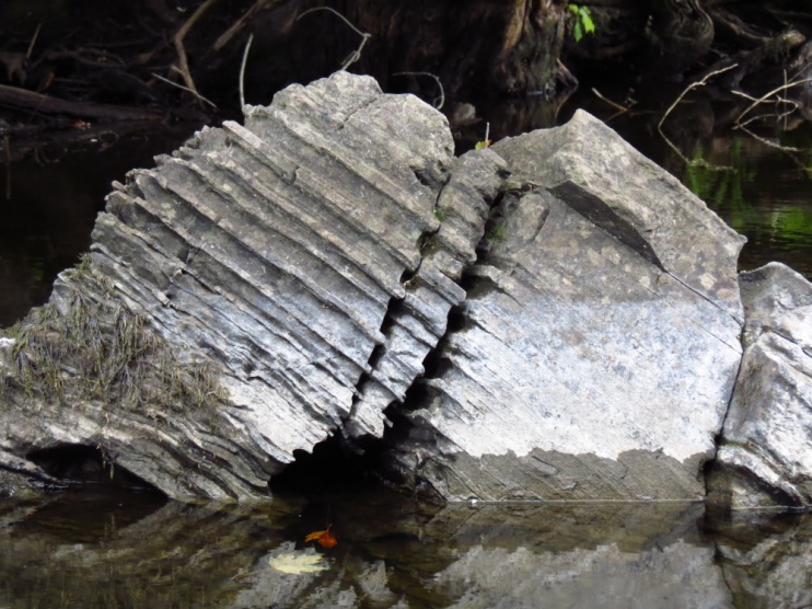
In this particular location on Beaver Creek, there is striking evidence of the Great Ice Age and the huge glaciers which carved and gouged out the landscape, scraping away the topsoil and leaving depositions of granite rocks, bare rock outcrops, cracked and broken slabs of limestone, a variety of metamorphic rock formations caused by pressure and stress, and the rough terrain typical of the Canadian Shield.
This section of Beaver Creek called, Fiddlar's Rapids, is a textbook example of the variety of processes that took place at the time of the receding glaciers, and the eroding remnants of that period in the earth's history.
What is also fascinating here in the Fiddlar's Rapids, is that we can see erosion happening in front of our eyes. Because this river is flooded every spring, there is a significant amount of water erosion taking place on the limestone beds, that we can witness, photograph and document.
Why is this Earthcache listed as Difficulty Level 5 and Terrain Level 5 ?
You are being asked to give descriptions of what you see and then make deductions based on your observations. The requirements may take some time, some research and some thought, in order to fulfil them. Furthermore, Beaver Creek Earthcache is only accessible by watercraft (canoe, kayak) and then, only in the months when fluctuating water levels are low enough so that the rocks are visible. The best, and perhaps only, months to visit are during July, August, September and possibly early October, (if warm enough). It is not possible to obtain the answers during the winter months when the rocks will be covered by ice and snow. Nor is it possible to complete this Earthcache in the months of April or May, as the spring run-off makes water levels so high that Beaver Creek's rocks are hidden below several feet of rushing water. In fact, Beaver Creek, including Fiddlar's Rapids, becomes a popular playground for white water kayakers ( MACKFEST, Marmora and Area Canoe and Kayak Festival). Environment Canada now posts information on water discharge levels for the various months of the year for Beaver Creek which you can access online (see the link in the RESOURCES). 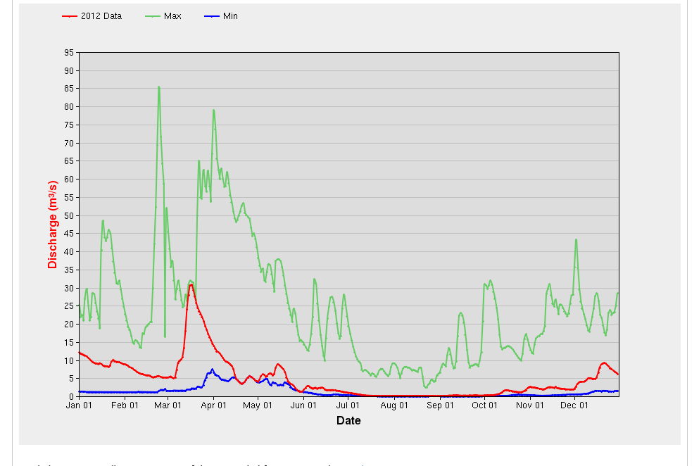
From the chart, you can see that your best bet for exploring the river bed of the Fiddlar's Rapids is during the summer and early fall. Please wear appropriate footwear for walking on a rough river bed and be prepared to get wet. Take a first aid kit in your boat and watch the sharp rocks on the bottom of your boat. Steer around them.
There are two main types of erosion evident in Fiddlar Rapids:
* Glacial Erosion
- historical (occurred in the past)
* Water/Flood Erosion
- current (is still happening)
Glacial Erosion:
Glaciers were the giant bodies of ice, sometimes up to several kilometres high, that covered much of North America before receding north; and which are responsible for most of the topography of the Canadian Shield. These glaciers were a powerful eroding machine that could pluck up huge pieces of rock, rolling and tumbling them until finally dumping them off (this process is called "plucking"). The plucked rocks and the ice in the glaciers gouged and carved the landscape. In Fiddlar Rapids, many of the features you see, are from glacier erosion. During the time of the glaciers, there were many catastrophic forces being exerted on the rock below the heavy masses of ice. The basal igneous rock, below the surface, was under immense pressure and stress, as well as temperatures of up to 700 degrees Celsius (which can be deduced by the presence of gneiss rock), causing minerals to be altered into the spectacular metamorphic formations you will see in Fiddlar's Rapids. 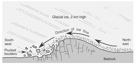 http://uwcm-geog.wikispaces.com/GLACIAL+EROSION (United World College)
Water Erosion:
Water erosion occurs from chemicals, saline content, and acid in the water, as well as the force (velocity) of the flow of water in a river. There are many chemicals that enter a river; and those chemicals can break down sedimentary rock, such as limestone. This eroded rock is then carried down the river. Sometimes, a crack or crevice develops. When the force of the flowing river smashes into that crack, continuously, over long periods of time, the rock can break away. Post glacial melt waters and the thousands of years of natural erosion following the Ice Age, in addition to our Canadian seasons of extreme temperature changes, have further impacted the rocks in Fiddlar's Rapids.
The following are the predominant features of Fiddlar's Rapids which fall into either the category of Glacial Erosion or River Erosion:
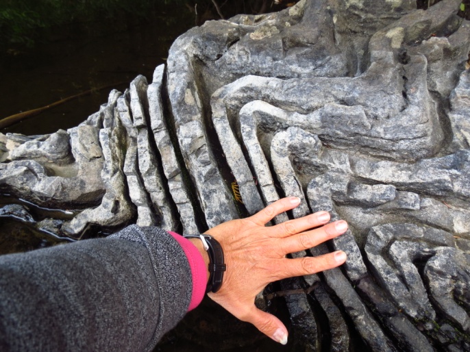
Folding
- is a feature of the glacier age. A fold occurs when one or a stack of originally flat and planar surfaces, such as sedimentary strata, are bent or curved as a result of permanent deformation. Similar to the way an accordion folds when pressure is applied to the outside of the instrument and the accordion is squeezed, folds in rock form under conditions of stress, hydrostatic pressure and temperature fluctuations. There is evidence here at Fiddlar Rapids of catastrophic folding of soft, waterlogged sediment and structures resulting from movement of sediment after deposition but prior to cementation. Some folds are symmetrical, while others are asymmetrical. Folds in rock are formed in relation to the rheology (the method of response to stress). For example, rocks that deform more easily, form many short-wavelength, high-amplitude folds. Rocks that do not deform as easily form long-wavelength, low-amplitude folds.
Glacial striations
are scratches or gouges cut into bedrock by glacial abrasion. Glacial striations are usually multiple, straight, and parallel, representing the movement of the glacier using rock fragments and sand grains, embedded in the base of the glacier, as cutting tools. Large amounts of coarse gravel and boulders carried along underneath the glacier provide the abrasive power to cut trough-like glacial grooves. Ice itself is not a hard enough material to change the shape of rock but because the ice had rock embedded in the basal surface, it could effectively abrade the bedrock.
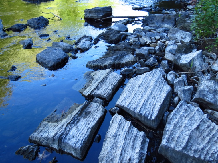
Clints, Grykes, Fissures and Interstices
- These are all erosive features mainly from the glacial period, although rocks do crack due to water erosion and the pressure of ice or tree roots. Limestone is slightly soluble in water and especially in acid rain, so corrosive drainage along joints and cracks in the limestone can produce slabs called "clints" isolated by deep fissures or interstices called "grikes" or "grykes". As water moves through spaces between mineral grains, it works to dissolve and carry away different elements. Some types of minerals are easily dissolved and others less so. Rainwater absorbs carbon dioxide (CO2) as it falls through the air. The carbon dioxide combines with water to form carbonic acid. This naturally occurring weak acid readily dissolves many types of rock, including limestone. Fissures are long, narrow cracks or openings in the face of a rock. Sometime fissures will fill with minerals of a different type from those in the surrounding rock. Limestone has a distinctive crystal structure and it will fracture and crack in a specific pattern. High carbon dioxide levels made the river water slightly acidic and it dissolved the limestone here in Fiddlar's Rapids, over thousands of years, widening the natural cracks and fissures in the rock.
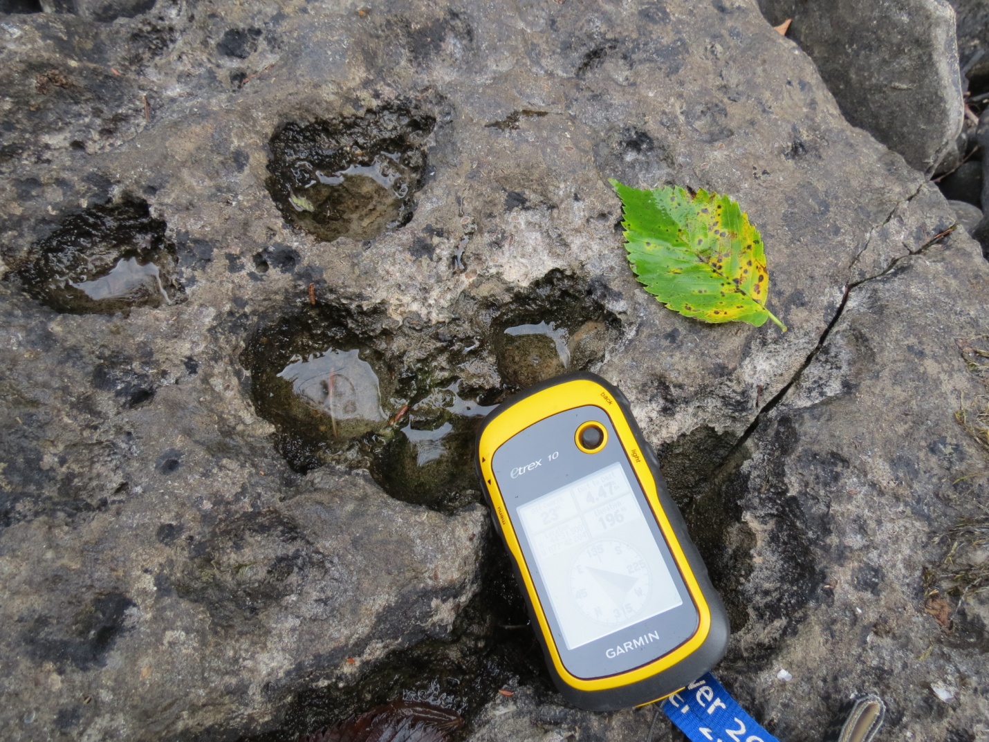
Potholes
- Potholes are small kettles (also known as "rockmills"). These develop in the bed of a fast flowing river wherever an eddy in the current causes stones or sand grains to be caught and swirled around in the same place over a long period of time. There are many small potholes in Fiddlar's Rapids. Geologists believe these were initially formed at the time of the Ice Age.
Slate
- Slate is shale that has been subjected to heat and intense pressure deep under the surface, usually in plate collision settings. Slate is created by regional, low-grade metamorphism of shale. It is composed of micaceous minerals, and could contain quartz, calcite, dolomite, feldspar, pyrite, graphite, chlorite, and other minerals. Slate is the finest grained foliated, homogeneous metamorphic rock. Chunks of flat dark grey slate are scattered throughout Fiddlar Rapids.
Fiddlar's Rapids is a geologist's heaven, because of the variety of geological features that can be clearly seen simply by walking up the river bed when water levels are low enough to be able to hop from rock to rock or simply wade in your rubber boots or water shoes. Beaver Creek's Fiddlar's Rapids is 350 metres of amazing examples of the ancient processes which occurred both during the glacier period and in the thousands of years of natural river erosion since that time.
Every rock in Fiddlar's Rapids has a story to tell. Your job is to figure out what those stories might be.
LOGGING REQUIREMENTS:
1. How many potholes do you think are in the 400 metres of Fiddlar Rapids? Close to 10? Closer to hundreds? Closer to thousands? Take a photo of an interesting pothole (if you can find a pothole), and upload it with your log.
2. Describe the water erosion marks at the posted coordinates. What is the cause of these lines and grooves? Do you think this is a result of glacial erosion or water erosion?
3. Find a fold. It does not need to be a fold which has interstices. It could just be an "S" shape you see in the rock. Tell whether the fold is a short wavelength, high amplitude fold or a long wavelength, low amplitude fold. Take a photo of the fold and post this with your log. If you need help, there is an amazing "S" curve here: N 44 31.390 W 77 41.860. I call it the "Snake". It is about 100 metres south of the posted coordinates. I suggest you paddle over to see it.
4. Over a kilometre north, there is a large rock that is very folded. I call it the "Labyrinth Rock". You do not need to go see it today, but if you ever wanted to, the co-ordinates for the "Labyrinth Rock" are N 44° 31.585 W 077° 42.128 . You can see a photo of it in the cache description. Can you find any rocks here, at the posted coordinates that might someday look similar to the "Labyrinth Rock" because of years and years of water erosion? If you find a rock that is starting to develop grooves, take a photo and upload it with your log.
Resources
http://www.marmoraandlake.ca/canoe-kayak/ Outside Web Page : http://mackfest.ca http://www.ruralroutes.com/5093.html
http://wateroffice.ec.gc.ca/report/report_e.html?type=realTime&stn=02HK006
http://www.myccr.com/phpBB3_PROD/viewtopic.php?t=10580&p=102571
http://countryroadshastings.ca/current-issue-s2.php?command=viewArticle&ID=55¤tFeed=3
http://www.geography-site.co.uk/pages/skills/fieldwork/fluvial/vel.html
http://quizlet.com/17348615/geology-final-flash-cards/
http://www.sentex.net/~tcc/pothart.html
http://darkwing.uoregon.edu/~drt/Classes/201_99/Rice/Metamorphic.html
Many thanks go to Moorely for all the help with html and developing this page.
| I have earned GSA's highest level: |
 |