SCALA DEI TURCHI
 [IT]
[IT]
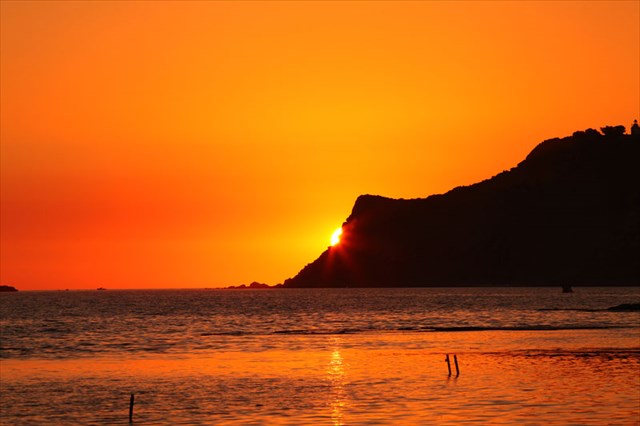
Vorrei mostrarvi un luogo di grande fascino, che ho avuto modo di vedere percorrendo la Sicilia. Vi invito alla SCALA DEI TURCHI.
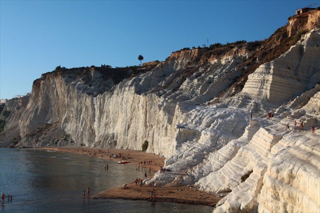
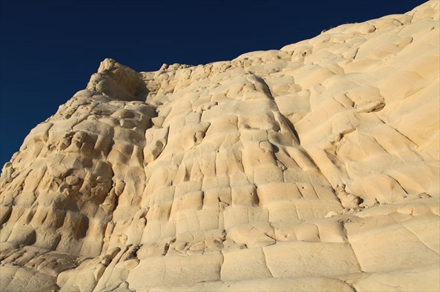
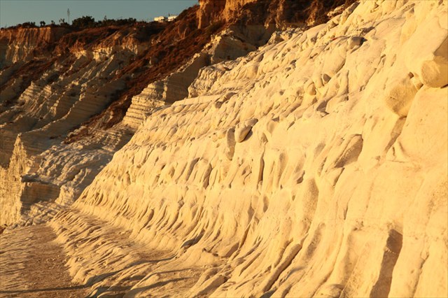
La SCALA DEI TURCHI è costituita da grandi falesie dalle forme imponenti, situate tra due spiagge sabbiose. Queste formazioni rocciose (che in alcuni punti assumono la forma di una scalinata) sono sorte in seguito all’erosione di falesie costituite da marne, pietra calcarea ed argille, caratterizzate dal colore bianco. Nel medioevo, queste “scale” venivano utilizzate dagli invasori turchi per conquistare la costa siciliana. Il loro nome attuale risale proprio a questo periodo storico. Ai nostri giorni sono una delle attrazioni naturalistiche più interessanti dell’intera Sicilia. Nel 2007, la SCALA DEI TURCHI è stata iscritta alla lista UNESCO.
Le coordinate riportate nel titolo portano all’accesso più vicino. Le “scale” vere e proprie si trovano presso le coordinate definite come waypoint1 – „EC”. Come indica la scritta presso l'entrata: „Siamo aperti tutto l'anno – lunedì chiuso”. É possibile raggiungere il luogo passeggiando su una delle due spiagge che circondano le "scale".
Prima di arrivare sul posto, tuttavia, vi consiglio di leggere le informazioni riportate a seguire e di rispondere alle domande.
La SCALA DEI TURCHI è una falesia, ossia una parete posta in riva al mare o ad un lago, comparsa in seguito all’attività erosiva delle onde (processo di abrasione), presso la base della formazione rocciosa (a contatto con la cosiddetta piattaforma di abrasione). A seconda dell’attività del processo di abrasione, si differenziano i seguenti tipi di falesia:
• Falesia viva (falesia attiva) – situata presso l’area di influenza delle onde ed erosa dalle stesso; è caratterizzata da una parete dall’aspetto affilato, spesso verticale, con una nicchia di abrasione ben visibile (solco di battente) alla base. Con il progressivo approfondimento del solco di battente, ha luogo l’asportazione ed il ritiro della riva;
• falesia morta – situata al di fuori dell’area di influenza delle onde, non è soggetta al processo di abrasione; solitamente è coperta da uno spesso strato di sedimenti diluviali;
• falesia ringiovanita – falesia morta nuovamente interessata dall’azione delle onde in seguito all’abbassamento della costa, all'innalzamento del livello dell’acqua o, periodicamente, in seguito all'azione di forti tempeste.
A seconda della disposizione degli strati rocciosi distinguiamo:
• falesia strutturale – creata da strati con pendenza verso la terraferma;
• falesia di scivolamento – creata da strati con pendenza verso il mare o il lago; oltre al processo di abrasione, sono modellate dallo spostamento e dallo scivolamento del materiale roccioso.

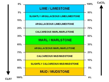
La SCALA DEI TURCHI è una formazione rocciosa naturale costituita da marne. Le marne sono rocce sedimentarie appartenenti al gruppo delle rocce chimiche. Si formano nei bacini marittimi o lacustri (marne lacustri), in seguito all'accumulo di grandi quantità di carbonato di calcio, mescolato con sostanze limose (principalmente minerali limosi). Costituiscono una formazione intermedia tra le rocce carbonatiche e le rocce limose. Con un contenuto di carbonato di calcio superiore a 67% si trasformano in calcari marnosi, mentre in presenza di un contenuto inferiore al 33% divengono limi marnosi. Le marne arricchite con una grande quantità di particelle di quarzo sono definite sabbiose. Colore bianco, marroncino o grigio. Esistono anche marne dal colore verdastro, causato dalla presenza di glauconite. Le marne sono utilizzate per la preparazione del cemento e come concime minerale.
Per ottenere il ritrovamento di questo Earth Cache, devi recarti presso le coordinate indicate come waypoint1 – „EC” e rispondere alle domande a seguire. Invia le risposte tramite il mio profilo. Non devi aspettare la mia risposta, puoi effettuare subito il login. Se ci saranno problemi, mi farò vivo da solo. Ricordatevi che i log senza risposte inviate saranno cancellati.
Domande :
1. Che tipo di rocce sono le marne ?
2. A che altezza ti trovi ( waypoint1 – „EC” ) ?
3. Sull’azimut 330 vedi la falesia più alta. Qual è la sua altezza ?
4. In vetta alla falesia si vedono le tipiche variazioni cromatiche (colore più scuro). Descrivi con parole tue da cosa sono causate.
5. Secondo te, su che tipo di falesia ti trovi ?
6. Se ne ha voglia, aggiungi al log la tua fotografia scattata presso la Scala dei Turchi.
Grazie e arrivderci.
 [EN]
[EN]
I’d like to show you a very charming place I came upon while travelling through Sicily. Let me invite you to the SCALA DEI TURCHI ("Stair of the Turks").
SCALA DEI TURCHI is a cliff, impressive in shape and size, located between two beautiful sandy beaches. These natural cascade formations (in some places similar to a staircase) are rock cliffs created by erosion, composed of marl, limestone and clay with a characteristic white color. In the Middle Ages, these "stairs" were used by the Ottoman armies to conquer the Sicilian coast. Their present name is derived from that period. Today they are one of the most interesting natural tourist attractions of Sicily. In 2007, SCALA DEI TURCHI have been entered on the UNESCO list.
The title coordinates lead to the nearest entrance. The "stairs" themselves are located under the coordinates for waypoint1 - "EC". To quote the inscription at the entrance: "Siamo Aperti Tutto L'anno - Lunedi Chiuso" - Open all year except Mondays. The “stairs” can also be accessed from one of the two surrounding beaches.
However, before you reach your destination, below you will find some interesting information and questions that I shall ask you to answer.
SCALA DEI TURCHI is a cliff, that is, a steep, often vertical wall of the sea or lake shore, formed by the process of the shore being washed away by the waves (this is the process of abrasion) occurring at its base, at the junction with the so-called wave-cut platform. Based on advancement of the abrasion process, the following types of cliffs are distinguished:
• living cliff (active cliff) - situated in the area subjected to waves and gradually eroded by them; creates a sharply outlined, often vertical edge with a distinct wave-cut notch at the base; as the notch deepens, the cliff is subjected to erosion and collapse;
• dead cliff - located outside the area of exposure and therefore no longer subject to the process of abrasion; usually covered with a thick layer of slope sediments;
• reactivated cliff - dead cliff, once again whipped by waves as a result of deflection of the coast, raising water level, or periodically during very heavy storms.
Based on the arrangement of rock strata, the following types of cliffs can be distinguished:
• rocky cliff – created in strata inclined toward the land;
• landslip cliff – created in strata inclined towards the sea or a lake; in addition to the abrasion process, it is also modeled by landslides and rock slippage.
SCALA DEI TURCHI is a rock formation of marl. Marl is a sedimentary rock classified in the group of chemical rocks. It is formed in marine or lacustrine reservoirs (“lake chalk”) as the result of accumulation of large amounts of calcium carbonate with an admixture of clay (mainly clay minerals). It constitutes a transitional formation between carbonate and argillaceous rocks. When calcium carbonate content reaches more than 67%, it turns into limestone marl, and when it drops below 33% - into marly clays. Marl enriched with a large amount of quartz grains is called sandy marl. Its color is white, brown or gray. There are also marls of greenish color, due to the presence of glauconite. Marl is used in the manufacture of cement and as a mineral fertilizer.
In order to complete this Earth Cache, you must go to the indicated coordinates marked as waypoint1 - "EC" and answer the questions below. Please submit your answers through my profile. No need to wait for my answer, you can log on immediately. If something goes wrong, I will let you know. Please remember that the logs without submitted answers will be deleted.
Questions :
1. What type of rock is marl?
2. At what height are you standing (waypoint1 - "EC")?
3. At azimuth 330 you see the highest cliff. What is its height?
4. At the top of the cliff you can see a characteristic pigmentation (darker color). Describe in your own words what caused it.
5. How do you think, what type of cliff are you standing on?
6. If you want it to, you can attach your own photo from Scala Dei Turchi to the log.
Thank you and best regards.
 [DE]
[DE]
Heute möchte ich Euch einen ganz besonders reizenden Ort vorstellen, den ich bei meiner Reise durch Sizilien entdeckt habe. Besucht mit mir die SCALA DEI TURCHI (Türkische Treppe).
Die SCALA DEI TURCHI sind weitläufige Kliffe mit beeindruckenden Formen, die zwischen zwei schönen Sandstränden aufragen. Diese natürlichen, kaskadenartigen Formationen (an einigen Stellen einer Treppe ähnelnd) sind infolge von Erosion entstanden. Die Felsenkliffe bestehen aus Mergel, Kalkstein und Lehm und weisen eine charakteristische weiße Farbe auf. Im Mittelalter wurde diese „Treppe“ von angreifenden türkischen Truppen zur Eroberung der sizilianischen Küste genutzt. Aus dieser Zeit stammt auch die heutige Bezeichnung. Heute gehören die Kliffe zu den größten natürlichen Sehenswürdigkeiten Siziliens. Im Jahr 2007 wurde die SCALA DEI TURCHI auf die UNESCO-Liste des Weltkulturerbes aufgenommen.
Die Titelkoordinaten führen zum nächstgelegenen Eingang. Die eigentliche „Treppe“ befindet sich unter den Koordinaten des Waypoint1 – „EC“. Wie die Aufschrift am Eingang besagt: „Siamo aperti tutto l’anno – lunedi chiuso“ – Ganzjährig geöffnet mit Ausnahme der Montage. Dorthin führt uns auch ein Spaziergang von einer der beiden Strände, die die „Treppe“ umgeben.
Bevor Ihr euch aber dorthin begebt, lest Euch zunächst einige interessanten Informationen und die folgenden Fragen durch und bereitet bitte Antworten vor.
Die SCALA DEI TURCHI ist ein Kliff, d.h. eine steile, häufig senkrechte Küstenwand eines Meers oder Sees, die durch das Unterspülen des Gesteins durch die Brandung (sog. Abrasion) am Fuß des Steilufers am Berührungspunkt mit der sog. Brandungsplattform entstanden ist. Je nach Aktualität des Abrasionsprozesses werden folgende Arten unterschieden:
• Lebendes Kliff (aktives Kliff) – im Einzugsbereich der Wellen gelegen und dadurch einer laufenden Abtragung unterworfen; bildet eine scharf geschnittene, häufig senkrechte Kante mit einer gut sichtbaren Brandungshohlkehle (Brandungsnische) am Fuß; je tiefer die Hohlkehle wird, desto stärker bricht das Kliff und wird zurückversetzt;
• Totes Kliff – außerhalb des Einzugsbereich der Wellen gelegen und dadurch dem Abrasionsprozess nicht mehr unterworfen; zumeist mit einer dicken Vegetationsdecke bedeckt;
• Verjüngtes Kliff – totes Kliff, das aber durch die Absenkung der Küste, das Ansteigen des Wasserspiegels oder kurzzeitig während sehr starker Stürme wieder von der Brandung unterspült wird.
Je nach Anordnung der Gesteinsschichten werden unterschieden:
• Strukturiertes Kliff – entsteht in den zum Land hin geneigten Gesteinsschichten;
• Rutschendes Kliff – entsteht in den zum Meer oder See hin geneigten Gesteinsschichten; wird außer dem Abrasionsprozess auch durch das Abrutschen und Abgleiten von Geröllmaterial modelliert.
Die SCALA DEI TURCHI ist eine Felsformation aus Mergel. Mergel sind Sedimentgesteine aus der Gruppe der chemischen Gesteine. Sie entstehen in Meer- oder Seebecken (Seemergel) infolge der Ansammlung von großen Mengen von Calciumcarbonat mit Tonbeimischungen (hauptsächlich Tonminerale). Mergel sind Übergangsformationen zwischen Carbonat- und Tongesteinen. Beträgt der Calciumcarbonatgehalt mehr als 67%, verwandelt sich Mergel in Mergelkalkstein, fällt der Anteil auf unter 33% - in Mergelton. Mit großen Mengen von Quarzkörnchen angereicherter Mergel wird Sandmergel genannt. Färbung: weiß, braun oder grau. Gelegentlich finden sich auch Mergel mit grünlicher Färbung - dies ist auf das Vorhandensein von Glaukonit zurückzuführen. Mergel werden zur Zementherstellung genutzt und als Mineraldünger verwendet.
Um die die Suche nach diesem Earth Cache angerechnet zu bekommen, musst Du dich zu den als Waypoint1 – „EC” markierten Koordinaten begeben und die folgenden Fragen beantworten. Bitte schicke mir die Antworten über mein Profil zu. Du musst meine Antwort nicht abwarten, sondern kannst Dich sofort einloggen. Falls etwas nicht in Ordnung ist, melde ich mich von selbst. Denkt bitte daran, dass Logs ohne Antworten gelöscht werden.
Fragen :
1. Zu welcher Gesteinsart gehört Mergel ?
2. Auf welcher Höhe befindest Du Dich? (Waypoint1 – „EC“) ?
3. Bei Azimut 330 siehst Du das höchste Kliff. Wie hoch ist es ?
4. Am Gipfel des Kliffs sind charakteristische Verfärbungen (dunklere Farbe) erkennbar. Beschreibe mit eigenen Worten, worauf diese zurückzuführen sind.
5. Was denkst Du, auf welcher Art von Kliff stehst Du ?
6. Falls Du Lust hast, füge dem Log Dein Foto von der Scala Dei Turchi bei.
Vielen Dank und freundliche Grüße.
 [PL]
[PL]
Chciałbym Wam pokazać niezwykle urokliwe miejsce na jakie trafiłem przemierzając Sycylię. Zapraszam Was na SCALA DEI TURCHI ( Tureckie Schody ).
SCALA DEI TURCHI to imponujące kształtami i rozmiarem klify położone pomiędzy dwoma pięknymi piaszczystymi plażami. Te naturalne kaskadowe formacje ( w niektórych miejscach przypominające swoim kształtem schody ) to powstałe w skutek erozji skalne klify zbudowane z margli, wapieni i gliny o charakterystycznej białej barwie. W średniowieczu „schody” te wykorzystywane były przez tureckich najeźdźców do zdobywania sycylijskiego wybrzeża. To właśnie z tamtego okresu pochodzi ich obecna nazwa. Dziś stanowią one jedną z ciekawszych przyrodniczych atrakcji turystycznych Sycylii. W 2007 roku SCALA DEI TURCHI wpisano na listę UNESCO.
Współrzędne tytułowe prowadzą do najbliższego wejścia. Właściwe „schody” znajdują się pod współrzędnymi określającymi waypoint1 – „EC”. Jak głosi napis przy wejściu : „Siamo Aperti Tutto L'anno - Lunedi Chiuso” – Otwarte przez cały rok z wyjątkiem poniedziałków. Na miejsce można się także dostać spacerując jedną z dwóch otaczających „schody” plaż.
Zanim dotrzecie jednak na miejsce, poniżej znajdziecie kilka ciekawych informacji oraz pytania na które poproszę abyście udzielili odpowiedzi.
SCALA DEI TURCHI to klif, czyli stroma, często pionowa ściana brzegu morskiego lub jeziornego, utworzona wskutek podmywania brzegu przez fale ( jest to proces abrazji ) zachodzącego u jej podstawy na styku z tzw. platformą abrazyjną. Ze względu na aktualność procesu abrazji wyróżnia się:
• klif żywy (klif czynny, klif aktywny) – położony w strefie oddziaływania fal i przez nie niszczony; tworzy ostro zarysowaną, często pionową krawędź z wyraźną niszą abrazyjną (podciosem brzegowym) u podstawy; w miarę pogłębiania się podciosu ma miejsce obrywanie się i cofanie brzegu;
• klif martwy – położony poza strefą oddziaływania fal, a więc nie podlegający już procesowi abrazji; zwykle pokryty grubą warstwą osadów stokowych;
• klif odmłodzony – klif martwy, ponownie jednak podcinany przez fale wskutek obniżenia się wybrzeża, podniesienia poziomu wody, lub okresowo w czasie bardzo silnych sztormów.
Ze względu na ułożenie warstw skalnych wyróżnia się:
• klif strukturalny – utworzony w warstwach nachylonych w stronę lądu;
• klif ześlizgowy – utworzony w warstwach nachylonych w stronę morza lub jeziora; oprócz procesu abrazji modeluje go również osuwanie i ześlizgiwanie się materiału skalnego.
SCALA DEI TURCHI to formacja skalna zbudowana z margli. Margle to skały osadowe zaliczane do grupy skał chemicznych. Powstają w zbiornikach morskich lub jeziornych (margle jeziorne), w wyniku nagromadzenia dużych ilości węglanu wapnia z domieszką substancji ilastych (głównie minerałów ilastych). Stanowią formację przejściową pomiędzy skałami węglanowymi a ilastymi. Przy zawartości węglanu wapnia powyżej 67% przechodzą w wapienie margliste, natomiast przy jego spadku poniżej 33% - w iły margliste. Margle wzbogacone dużą ilością ziaren kwarcu nazywa się marglami piaszczystymi. Barwa biała, brunatna lub szara. Zdarzają się także margle o zabarwieniu zielonkawym, spowodowanym obecnością glaukonitu. Margle stosowane są do wyrobu cementu i jako nawóz mineralny.
Aby zaliczyć znalezienie tego Earth Cache, musisz udać się pod wskazane współrzędne oznaczone jako waypoint1 – „EC” i odpowiedzieć na zamieszone poniżej pytania. Odpowiedzi proszę wysyłać za pomocą mojego profilu. Nie trzeba czekać na moją odpowiedź, można od razu logować. Jeśli coś będzie nie tak, zgłoszę się sam. Pamiętajcie proszę, że logi bez podesłanych odpowiedzi będą kasowane.
Pytania :
1. Margiel to jakiego rodzaju skała ?
2. Na jakiej wysokości się znajdujesz ( waypoint1 – „EC” ) ?
3. Na azymucie 330 widzisz najwyższy klif. Jaka jest jego wysokość ?
4. U szczytu klifu widać charakterystyczne przebarwienia ( ciemniejszy kolor ). Opisz własnymi słowami czym one są spowodowane.
5. Jak sądzisz, na jakiego typu klifie stoisz ?
6. Jeżeli masz ochotę, to do logu załącz swoje zdjęcie z Scala Dei Turchi.
Dziękuję i pozdrawiam.