Draper Mountain is, at its highest, 3,350 feet above sea level. Because of this you get to see some awesome views. Here you will be able to see both sides of the mountain, but do be careful when crossing the road.
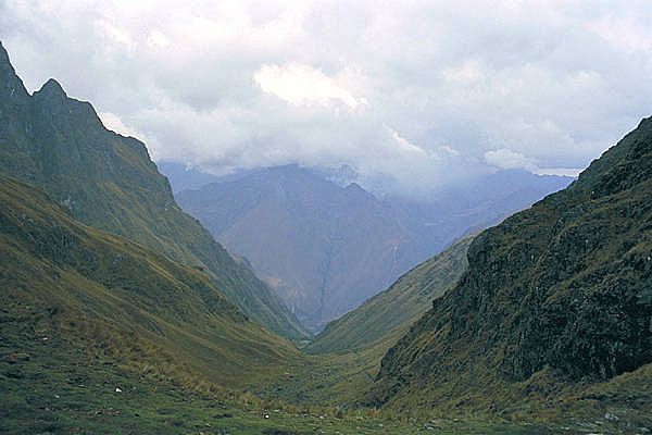
The valley to the north was carved from varies forms of erosion most noticeably from the Valley branch stream. This stream, which runs through the valley, is a tributary for Peak River which in turn is a tributary for the New River.
The valley to the South was carved from varies forms of erosion most noticeably from the New River. The New River, part of the Ohio River watershed and is considered by some geologists to be one of the oldest rivers in the world. The New River is unique in that it flows in a generally south-to-north course, differing with the west-to-east flow of most other major rivers to the east and northeast in Virginia and North Carolina. This strange direction, along with the river’s many cuts through numerous erosion-resistant Appalachian rocks, tells us that the New River's formation come first before the uplift of the Appalachian Mountains.
Draper Mountain Overlook: Originally constructed by the Civilian Conservation Corps (CCC) during the great depression. The Overlook includes parking areas with scenic views overlooking the Town of Pulaski which sits in a valley to the north and Draper Valley to the south. Located on both sides of US Route 11 are walking trails and picnic tables.
Valley
A valley is an extended depression in the Earth's surface that is usually bounded by hills or mountains and is normally occupied by a river or stream. Because valleys are usually occupied by a river, they can also slope down to an outlet which can be another river, a lake or the ocean.
Valleys are one of the most common landforms on the Earth and they are formed through erosion or the gradual wearing down of the land by wind and water. In river valleys for example, the river acts as an erosion agent by grinding down the rock or soil and creating a valley. The shape of valleys varies but they are typically steep-sided canyons or broad plains, however their form depends on what is eroding it, the slope of the land, the type of rock or soil and the amount of time the land has been eroded.
There are three common types of valleys which include V-shaped valleys, U-shaped valleys and flat floored valleys. (Victor R. )
V-Shaped Valley
A V-shaped valley, sometimes called a river valley, is a narrow valley with steeply sloped sides that appear similar to the letter "V" from a cross-section. They are formed by strong streams, which over time have cut down into the rock through a process called downcutting. These valleys form in mountainous and/or highland areas with streams in their young stage. At this stage, streams flow rapidly down steep slopes. (Victor R. )
Source: http://www.quia.com/files/quia/users/fleach/Landforms/landforms-V-shaped-valley
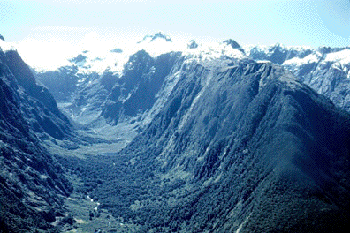
U-Shaped Valley
A U-shaped valley is a valley with a profile similar to the letter "U." They are identified by steep sides that curve in at the base of the valley wall. They also have broad, flat valley floors. U-shaped valleys are formed by glacial erosion as massive glaciers moved slowly along. U-shaped valleys are found in areas with high elevation and in high latitudes, where the most glaciation has occurred. Due to their large size and weight, glaciers are able to completely alter topography, but it is the alpine glaciers that formed most of the world's U-shaped valleys. This is because they flowed down pre-existing river or V-shaped valleys during the last glaciation and caused the bottom of the "V" to level out into a "U" shape as the ice eroded the valley walls, resulting in a wider, deeper valley. For this reason, U-shaped valleys are sometimes referred to as glacial troughs. (Victor R. )
Source: http://geoscience.wisc.edu/~chuck/Classes/Mtn_and_Plates/Images/C124glaciated_valley.gif
Flat-Floored Valley
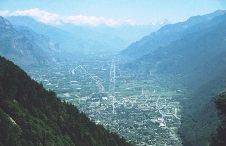
The third type of valley is called a flat-floored valley and is the most common type in the world. These valleys, like V-shaped valleys, are formed by streams, but they are in their mature stage. The valley floor gets wider. Because the stream gradient is moderate or low, the river begins to erode the bank of its channel instead of valley walls. This eventually leads to a meandering stream across a valley floor. Over time, the stream continues to meander and erode the valley's soil, widening it further. With flood events, the material that is eroded and carried in the stream is deposited which builds up the floodplain and the valley. During this process, the shape of the valley changes from a V or U shaped valley into one with a broad flat valley. (Victor R. )
Source: http://geography-site.co.uk/pages/physical/glaciers/images/trough.jpg
What is Erosion?
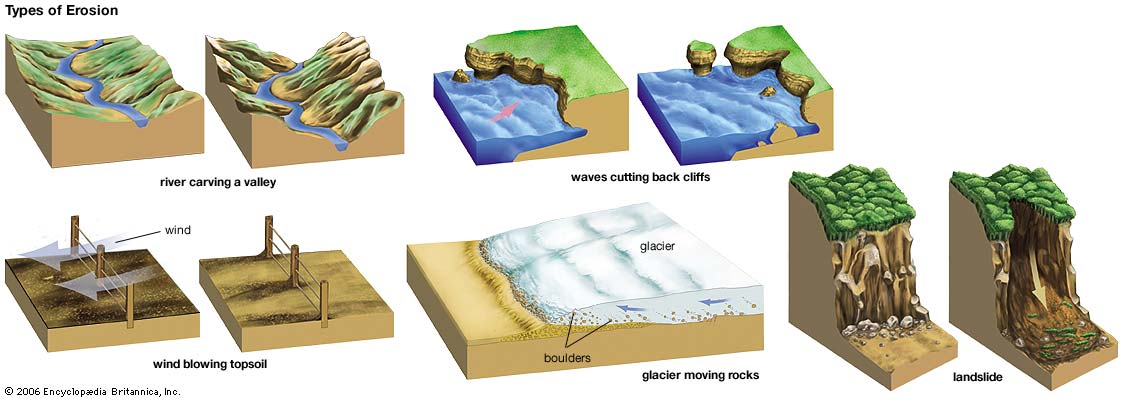
Erosion is the process by which soil and rock are removed from the Earth's surface by natural processes such as wind or water flow, and then transported and deposited in other locations. In this particular area at GZ, Water has caused most of the Erosion here.
Types of Erosion:
Splash Erosion: Small soil particles are detached and sent airborne through the impact of raindrops on soil.
Sheet Erosion: Raindrops break apart the soil structure and it's moved down-slope by water that flows overland as a sheet rather than definitive channels. This occurs frequently during cloud bursts.
Rill Erosion: This process develops small, short-lived, concentrated flow paths. These paths create a sediment source and delivery system for hill-slope erosion. Areas where precipitation rates exceed soil infiltration rates are more prone to this type of erosion.
Gully Erosion: Water flows in narrow channels during or directly following heavy rains or melting snow. The gullies can erode to considerable depths.
Valley or Stream Erosion: Continual water flow alongside land (along a linear feature) creates this type of erosion. It extends downward, deepening a valley, and head-ward, extending the valley into the hillside. This occurs most frequently in times of flooding.
Bank Erosion: Over time, banks of rivers and streams are naturally worn down.
Freezing and thawing: Cold weather causes water trapped in tiny rock cracks to freeze and expand, breaking the rock into several pieces.
Source: (water)
Sources
**Logging requirements**
DO NOT POST ANSWERS IN YOUR LOG.
Send the following answers to me via email.
- The text "GC5CPK7 Draper Valley View" on the first line
- What is the elevation here?
- What type of valley is this?
- What is the distance to waypoint “valley bottom”?
At waypoint "limestone"
- How many limestone steps are there here and what color are they?
At waypoint "South"
- What type of valley is this side?
| I have earned GSA's highest level: |
 |