GéoRandonnée des Lacs
Je vous propose une belle GéoRandonnée dans les alentours du Lac du Mont Cenis, mais à l'écart des foules estivales.
Ecco una bella geo-passeggiata intorno al lago del Moncenisio, lontano dalle folle estive.
I suggest you a nice GéoHike near the Mont Cenis Lake, but away from the summer crowds.
Avec au bout d'une journée entière de rando, 1 SEULE cache ! : inutile de dire que ce n'est pas pour la cache que vous tenterez l'aventure, mais pour la rando, que je vous promets très sympa.
Sarà quasi un'intera giornata di cammino, ma con 1 solo cache finale ! Quello che conta, infatti, non è l'avventura del ritrovamento di un solo cache, ma di affrontare l'intera passeggiata: sarà molto spettacolare !
At the end of a full day of hiking : only 1 cache ! : needless to say that it is not for it that you will try the adventure, but for the hike, I promise you very nice !
dénivelés : +790m,-900m ; environ 15 km ; 6h à 7h
10 indices à relever tout au long du parcours pour connaître la position de la cache
Per conoscere la posizione finale del cache, affrontate i 10 stage lungo la strada
10 indices to find all along the way to know the position of the cache.
Suivez ( et imprimez ? ) les instructions suivantes :
Seguite ( e stampate ! ) le seguenti istruzioni :
Follow ( and print ? ) the following instructions:
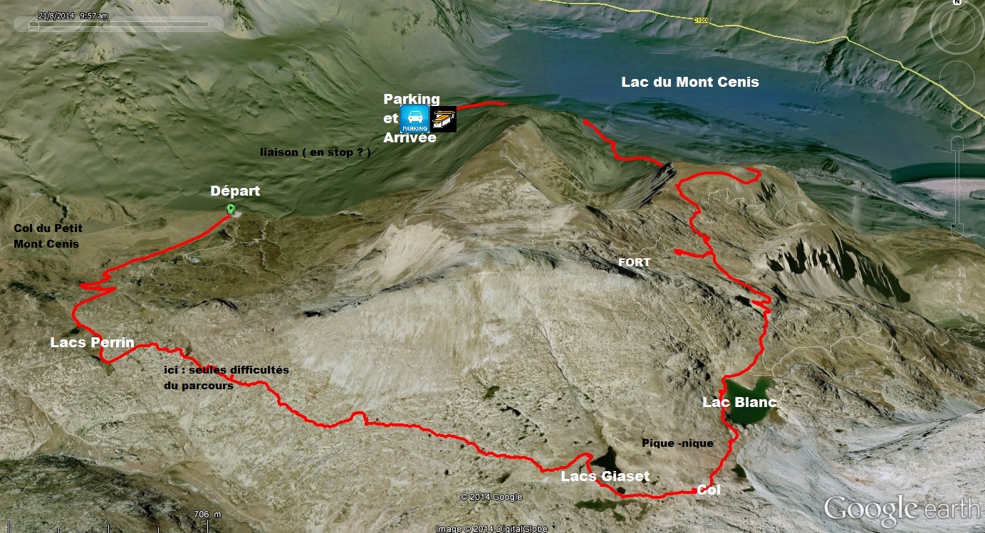
A. Garez-vous en P15BWR2 - N 45° 13.921 E 006° 53.938
----------------
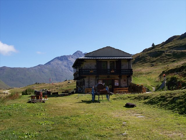
B. Rendez-vous ( je vous conseille en stop ) au parking du Refuge du Petit Mont-Cenis ( PK5BWR2 - N 45° 13.074 E 006° 53.099 ), puis au Refuge ( RR5BWR2 - N 45° 12.953 E 006° 53.001)
----------------
C. Étape 1 : S15BWR2 - N 45° 12.942 E 006° 52.998
A = à quelle distance se trouve TAHITI ? ( A = chiffre des centaines de km )
----------------
D. Étape 2 : S25BWR2D - N 45° 12.701 E 006° 52.645
B = les refuges italiens Avanza et Vaccarone sont à 3h*5mn ( B=*) de marche
Continuez vers les lacs Perrin.
----------------
E. Étape 3 : S35BWR2D – N 45° 12.313 E 006° 52.817 - Lac Perrin Inférieur - 2320m
C = sur le panneau, il est indiqué : r2* ( C=* )
Continuez vers les lacs Giaset.
----------------
F. Étape 4 : S45BWR2D – N 45° 12.161 E 006° 52.985 - Lac Perrin Supérieur - 2340m/2360m
D = les lacs Giaset sont à 1h*5 ( D=* ) de marche
Prendre à gauche vers les lacs Giaset.
----------------
G. Étape 5 : S55BWR2D – N 45° 11.615 E 006° 54.714 - panneau en bois gravé - Lac Giaset
E = le nombre total de O, de o ( les lettres ) ou de 0 ( le chiffre ) qu'il y a sur ce panneau en bois
Continuez vers le Col du/des Lac(s) Giaset
----------------
H. Étape 6 : S65BWR2D – N 45° 11.549 E 006° 55.008 - Col des Lacs Giaset
F = le nombre de mots qu'il y a sur cette vieille pancarte ( métallique - CHASSE ... ) fixée au rocher
Continuez vers le Lac Blanc
----------------
I. Étape 7 : S75BWR2D – N 45° 11.802 E 006° 55.161 - Lac Blanc
G = le nombre de lignes ( d'écriture ) inscrites sur cette vieille pancarte rouillée ( quasi illisible ) - Attention ! : dans la formule finale, on n'utilisera pas G , mais ( G-1)
----------------
J. en TG5BWR2D - N 45° 11.980 E 006° 55.331 - Quitter le chemin Principal
----------------
K. Étape 8 : S85BWR2D – N 45° 12.335 E 006° 55.149 - La Caserne
H = le chiffre des unités de l'année de construction de la caserne
----------------
L. en QR5BWR2D - N 45° 12.588 E 006° 55.284 - Quitter la route.
----------------
M. Étape 9 : S95BWR2D – N 45° 12.762 E 006° 55.255 - FLEURS
le nom de cette fleur ( vous en rencontrerez des quantités incroyables aux alentours sur environ 1km ) comprend 5 consonnes et I voyelles
----------------
N. BG5BWR2D – Borne - N 45° 13.462 E 006° 55.262 - Prendre à gauche.
----------------
O. Étape 10 : SA5BWR2D – N 45° 13.478 E 006° 55.142 - Panneau
J = le nombre de fois où la lettre o ou O est écrite sur le panneau de la destination située à 1h05
----------------
P. en FI5BWR2D - N 45° 13.840 E 006° 55.024 - Fin des Indices - Vous pouvez maintenant calculer la position du FINAL ( mais vous pouvez attendre d'être retourné au Parking de DEPART pour le faire ) et retourner au Parking de DEPART P15BWR2D ( éventuellement en stop )
----------------
( A + B + C + D + E + F + G + H + I + J = 36 )
Q. FINAL : N45° AB.CDE E06° F(G-1).HIJ
ATTENTION : utilisez G-1, pas G
et surtout :
TRES BONNE RANDONNEE


A. Park your car in P15BWR2
----------------
B. Rendez-vous ( I suggest you to hitchhike ) at the Parking of the Refuge du Petit Mont-Cenis ( PK5BWR2 ), and by foot at the Refuge ( RR5BWR2 )
----------------
C. Step 1 : S15BWR2
How far is Tahiti ? ( A = number hundreds of km )
----------------
D. Step 2 : S25BWR2D
B = to go to the refuges Avanza or Vaccarone, you will hike 3h*5mn ( B=* )
Continue to Perrin lakes
----------------
E. Step 3 : S35BWR2D - Lower Lake Perrin - 2320m
C = on this panel, it is written : r2* ( C=* )
Continue to Giaset lakes.
----------------
F. Step 4 : S45BWR2D - Lake Superior Perrin - 2340m
D = you will hike 1h*5 ( D=* ) to go to the lakes Giaset
Turn left towards the Giaset lakes
----------------
G. Step 5 : S55BWR2D - Lake Giaset
E = the total number of O, o ( letters ) ou 0 ( number ) written on this wooden panel
Continue to the Col of Lake(s) Giaset
----------------
H. Step 6 : S65BWR2D - Col of Lakes Giaset
F = the number of words written on this old panel ( CHASSE ... ) fixed on the rock
Continue to the Lac Blanc
----------------
I. Step 7 : S75BWR2D - Lac Blanc
G = the number of writing lines written on this old pannel ( unreadable and rusty )
Warning ! : in the final formula, don't use G but ( G-1)
----------------
J. in TG5BWR2D - Principal Road Exit
----------------
K. Step 8 : S85BWR2D - Barracks
H = the units digit of the year of construction of the barracks
----------------
L. in QR5BWR2D - Leave the road.
----------------
M. Step 9 : S95BWR2D - FLOWERS
the name of the flower ( you will meet incredible amounts around about 1km ) has 5 consonants and I vowels
----------------
N. BG5BWR2D - Borne - Turn left.
----------------
O. Step 10 : SA5BWR2D - Panel
J = the number of letters o or O written on the pannel of the destination situated at 1h05
----------------
P. in FI5BWR2D - End of Indices - You can now calculate the position of the FINAL ( but you can expect to be returned to Parking START to do it ) and return to the car park START P15BWR2D ( you can try to hitchhike )
----------------
( A + B + C + D + E + F + G + H + I + J = 36 )
Q. FINAL : N45° AB.CDE E06° F(G-1).HIJ
WARNING : use G-1, not G
VERY GOOD HIKE !
( Thank you for your comments to improve this translation )