Miami Beach Breakwaters EarthCache
-
Difficulty:
-

-
Terrain:
-
Size:  (other)
Please note Use of geocaching.com services is subject to the terms and conditions
in our disclaimer.
This Earthcache provides you with an opportunity to learn about and closely study the breakwater structures placed on this beach to prevent the chronic beach erosion that has plagued this particular area for many years.
Access to the Earthcache
A waypoint is provided for parking in the 35/36 Street Parking Lot (there is a parking fee). Parking can also be found on nearby streets at meters. A trailhead waypoint is included where you may access the beach near the parking lot and walk 800 feet or so to GZ. Or, you may walk south along the boardwalk to the next provided waypoint at 32 Street and then access the beach, and walk to GZ from there.
Breakwaters
Breakwaters are generally piles of large rocks or manmade blocks that can be placed parallel to the beach area to interrupt or redirect the natural forces and flow of the ocean. There are two main types of breakwaters that are typically used. Detached breakwaters are constructed offshore of the beach, 100 or more feet from shore. They encourage accretion (deposition) of sand onto the beach area thereby building the beach. This process would cause the suspended sand carried by the longshore drift (the ocean current that moves north to south in this area) to be deposited on the shoreline, just inside the breakwaters. Detached breakwaters build beaches near them, but unfortunately they tend to accelerate erosion of the beaches downdrift (south) of the breakwaters by robbing sand from the longshore current and creating current eddies that tend to scour the beach just south of the structures. Attached breakwaters however, generally protect an existing beach without robbing sand from the longshore current while providing erosion protection from wave action. Sand that remains in the longshore current can be deposited onto beaches downdrift (south) of the structures. Attached breakwaters are essentially artificial headlands that protect the shoreline.
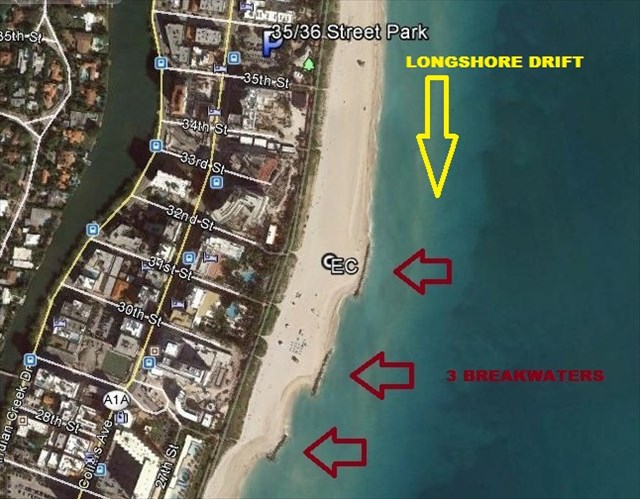
Photo
The below photo shows the position of the 3 breakwaters, the constructed sand beach, and the direction of the longshore drift/current in this area.
Background
This area of Miami Beach has been identified an erosional hot-spot that has suffered badly from beach erosion over the years because of the slight protrusion of the shoreline at this particular location. Millions of dollars have been spent on beach re-nourishment in the past, so a cost-effective, more permanent solution was needed.
Solution
In 2002, engineers constructed three attached breakwaters in this area. First, they reshaped this beach with the available on-site sand, and then constructed the three attached breakwaters with over 7,000 tons of rock to protect the constructed beach. The visible rocks at this location are actually limestone. This system minimizes the deposition or removal of suspended sand from the longshore current and simply maintains the already constructed beach. The sand-filled longshore current bypasses these structures. Therefore, beaches that are downdrift (south) will/should not suffer dramatically from lack of sand in the longshore current and would not erode as quickly as they would if detached breakwaters were used. In addition, placing the southernmost headland closer to shore at an angle reduces the severity of erosion to the south. This design is more streamlined so the longshore currents quickly transition back to their normal flow patterns. However, despite the design, some beach renourishment has been necessary in the area of 25 Street (just south of the breakwaters). At the earthcache location, breakwaters are in place to stop erosion of the constructed beach, rather than to develop a new beach by sand accretion. Monitoring of the effects of the breakwaters continues.
References: CoastalWiki, Coastal Systems Int’l., Wikipedia
Completing the Earthcache
To get credit for completing this Earthcache, please send your answers to the following questions to our profile Email. Incorrect answers may lead to further questions from us, or deletion of your find log. You may log your find after you have transmitted your answers.
1. What type of breakwater has been constructed here?
2. Standing at the posted coordinates, estimate how high above the sea-level the beach you are standing on is (in feet or metres)?
3. By observing the waves’ action against the rocks/boulders in the breakwater structure, would you say that the breakwater is decreasing or increasing the energy of the waves?
4. Do you think that the breakwaters are preventing beach erosion, causing beach erosion, or both?
Optional: Photos are optional, but they are welcomed. You may add photos of you and your party standing near the breakwater.
"When one tugs at a single thing in nature, he finds it attached to the rest of the world." - John Muir
| MnS has earned GSA's highest level: |
 |

Additional Hints
(No hints available.)