South Pointe Park Jetty EarthCache
-
Difficulty:
-

-
Terrain:
-
Size:  (other)
Please note Use of geocaching.com services is subject to the terms and conditions
in our disclaimer.
This Earthcache brings you to a rock jetty that was constructed many years ago to protect the very deep and extremely important shipping channel that leads to the PortMiami. The jetty and pier are accessible from the South Pointe Park.
Completing the Earthcache
To get credit for completing this Earthcache, please send your answers to the questions below to our profile Email. You may log your find after you have transmitted your answers. Note that if you don’t send the answers your log will be deleted.
Access to the Earthcache area
A waypoint is provided for the nearby Parking Lot entrance (there is a parking fee) for South Pointe Park. You may begin your observations from the posted coordinates, but two waypoints are provided for additional observation areas. One is along the top of the actual jetty structure which is paved up to the waypoint. The second waypoint is at the end of the pier which is more fun and the views are better (the pier is open from sunrise to sunset).
Jetty
A jetty is a structure, usually a pair of structures made up of rocks or man-made blocks that project perpendicularly out into a body of water to influence the current or tide and/or to protect a harbor entrance or other navigable shipping channel from erosion or accretion (deposition of sand). Jetties keep the waterway navigable.
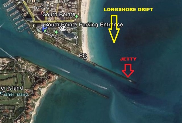
Photo
The below photo shows the entrance to the parking Lot, GZ for the EC, the Jetty, the Government Cut shipping channel, and the direction of the longshore drift/current that carries sand grains with it.
Background
The Government Cut channel was created in 1902 for ship passage to the PortMiami just west of the beachfront. The channel was originally dredged to -18 feet below sea level, but since 1985 it was deepened to -42 feet in order to accommodate cruise line ships and large cargo container ships that pass through to dock at the PortMiami. Recently, the channel has been deepened to -50 feet for even larger ships to be able to pass.
Longshore drift (the process whereby the ocean current that moves north to south in this area along the beach) was depositing sand, that was picked up by the longshore current from the northern beaches, into the deep shipping channel so that frequent maintenance dredging of the channel was required. This was very costly, but without adequate depth in the channel, ships can become grounded in the channel.
Solution
This particular jetty structure, about 2,300 feet long, on the updrift (north) side of the channel was constructed to prevent sand from entering and clogging the channel, to encourage the deposition of sand on the north side of the jetty, and also to re-direct the longshore currents (that may still contain sand) further out to sea beyond the channel. Limestone was used as the base rock, with granite as the visible cap stone. In this case, the South Pointe jetty protects the entrance channel of Government Cut. In 1983, and again in 1998, it was discovered that the jetty was allowing too much sand to pass through it and into the channel, indicating that there was significant leakage through the jetty structure. Sand-tightening projects were implemented that closed voids or spaces in the large rocks and decreased the sand leakage into the channel. No further repairs have been made to the jetty structure since then.
References: Sea Grant Delaware, Wikipedia, Beachapedia, Ocean Science
Completing the Earthcache
To get credit for completing this Earthcache, please send your answers to the following questions to our profile Email. You may log your find after you have transmitted your answers.
From the posted coordinates, or the provided waypoints:
1. Does the beach area on the updrift (north) side of the jetty appear to be narrow and badly eroded, or does it look healthy and well-filled with sand?
From either of the two provided waypoints (Rocky Trail or Pier Lookout):
2. Estimate the average size of the rocks (feet or metres) that form the top, visible portion of the jetty.
3. Estimate how wide this jetty structure is (feet or metres).
4. Looking into the water on the immediate south side of the jetty, do you see any water currents or sand passing into the channel through the jetty?
"When one tugs at a single thing in nature, he finds it attached to the rest of the world." - John Muir
| MnS has earned GSA's highest level: |
 |

Additional Hints
(No hints available.)