The Mecklenburg County Greenway system is quickly becoming one of the finest in the country. Greenways are vegetated natural buffers that improve water quality, reduce the impacts of flooding, and provide wildlife habitat. Greenway trails provide recreation, transportation, fitness, and economic benefits for all to enjoy. There are over 35 miles of developed greenways in Mecklenburg County. [from http://charmeck.org/mecklenburg/county/ParkandRec/Greenways/OpenGreenways/Pages/default.aspx]
Link to Map
http://charmeck.org/mecklenburg/county/ParkandRec/Greenways/OpenGreenways/Documents/Lower_McAlpine_and_McMullen_and_Four_Mile_Creek_Map.pdf
The parking area in the center of the map, along Johnston Rd, is the closest parking location for this Earthcache.
Floodplains, Water Speed, and Clast Sizes
A
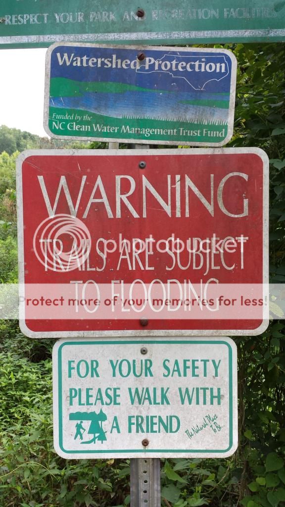
floodplain is the flat land beside a stream that floods from time to time--in Charlotte, usually after a big rain. When the floodplain is covered with water, the stream deposits sediment across the plain. If you show up at the Greenway after a flood event, you can often see sand and mud on the paved paths and boardwalks. Watch out! The mud can be slippery for walking and biking, so be careful.
Clasts
Sediment comes in various sizes from boulders (biggest) to clay (smallest). These sedimentary particles are called
clasts, which are really just fragments of rock. The type of rock that composes clasts depends on the underlying geology of the area of land drained by the stream. For example, sand in Hawaii is very different from sand on the beaches of the Carolinas because the source rocks of Hawaii differ from the source rocks of North and South Carolina.
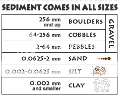
[from http://www.scienceviews.com/geology/sedimentary.html]
The speed of water has everything to do with the size of clasts you see. Simply put:
the faster the water, the bigger the clast. It takes very swift water to move boulder-sized clasts, so if the water isn’t fast enough, it flows around boulders, which stay in place. Some streams flow so slowly that they can move clasts only as big as sand.

[from http://www.coolgeography.co.uk/GCSE/AQA/Water%20on%20the%20Land/Meanders/Landforms%20Meanders.htm]
Fast moving water has enough energy to carry a large amount of materials, known as the stream's load. Raging floodwaters can pick up small-to-large sized particles and carry them until they no longer have the energy to keep them suspended.
When the stream water level rises, it will overflow its banks, spreading out into the adjacent fields. The water slows quickly and drops the heavier particles it has been carrying. This leaves a higher bank along the stream's edge, known as a natural levee. As the water spreads farther from the channel and slows even more, it drops its sediment load, adding silt and sand to the soils present there.
Flooding is a natural and expected aspect of the life of a stream. To think that we can stop it is naïve. With luck we may be able to exert limited control over it and minimize the damage. For this reason, many communities have zoning ordinances regarding building on floodplains. [from http://www.atlas.keystone.edu/edu/virtual/water_discovery/Station15.html]
Questions
At the coordinates, you’ll be standing on a boardwalk surrounded by water on the floodplain. Email me your answers. Do not put them in your log.
1. Describe the speed of the water at this site.
2. What size of clast would you expect to find if you dug down below the water? Note: Do not actually dig down.
3. Why did you pick that clast size in #2?
4. If you did this Earthcache right after the stream flooded, describe any encounters with clasts on the paths.
5. (Optional) Did you see any animals during your time on the Greenway? Which one(s)?
6. (Optional) Post photos of any animals you see.
7. (Optional) Post photos of yourself enjoying the floodplain.