OS ILHÉUS DA MADALENA
[Pico – Azores]
PIC4
EARTHCACHE

PORTUGUÊS

OS ILHÉUS DA MADALENA:
Ilhéu Deitado, Ilhéu em Pé
e Ilhéu Iluminado…
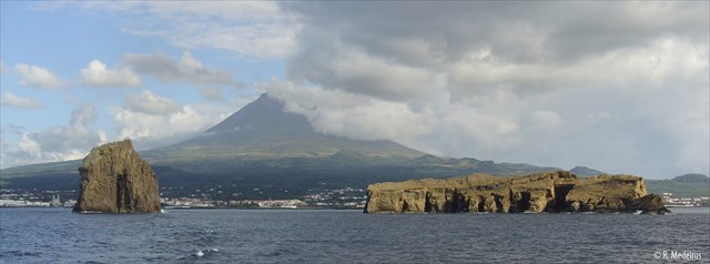
Os Ilhéus da Madalena (PIC 1) pertencem ao município da Madalena, na Ilha do Pico, Região Autónoma dos Açores. Situam-se na parte norte do Canal do Faial, a 0,5 milhas náuticas (ou seja, a 8 km) do porto da vila da Madalena. Este fenómeno é formado por 2 ilhéus: o Ilhéu Deitado, com 52 metros, e o Ilhéu em Pé, com 59 metros, de altura. As suas coordenadas geográficas são: 38º 31.80' Latitude Norte e a 28º 32.40' Longitude Este.
Correspondente aos restos de um aparelho vulcânico submarino quase destruído pela abrasão marinha e pela ação de forças tectónicas. O seu fundo é uma antiga cratera em rocha de tufo. Os materiais que os constituem são de origem hidro-magmática, nomeadamente tufos palagoniticos muito soldados. Na zona abrigada pelos ilhéus, chega aos 20 metros de profundidade. Nos fundos circundantes, há clareiras de areia e zonas com elevada acumulação de "calhau rolado".
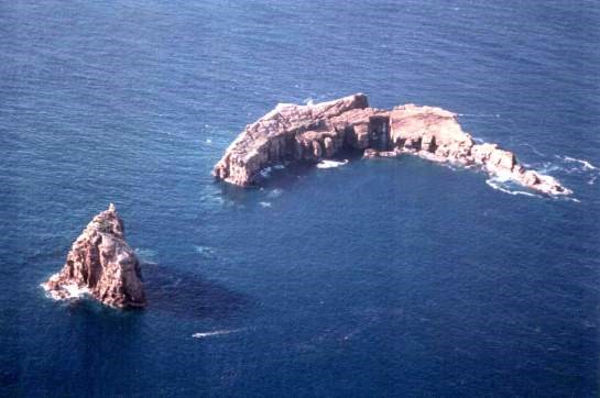
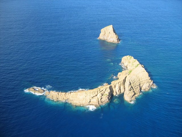
Quem olhar com atenção a forma do Ilhéu Deitado (mais baixo e longo) e a posição do Ilhéu em Pé (mais alto), verifica que eles formam um anel que corresponde à sua distribuição em torno da cratera do vulcão submarino que esteve na sua origem.
No passado, os dois ilhéus formariam uma única ilhota, circular ou em forma de ferradura, cuja zona central corresponderia à cratera. Depois o vento, a chuva e sobretudo o mar foram destruindo aquele edifício vulcânico, cuja formação foi semelhante à do Monte da Guia, Costado da Nau e primeira fase dos Capelinhos na ilha do Faial.
Trabalhos de investigação efetuados propõem a classificação desta zona como uma Reserva Natural.
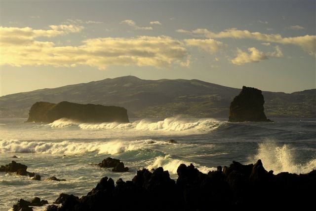
Tem como flora dominante a Sphacelaria plumula, Lithophylum incrustans e Pterocladia capilacea. Da sua fauna caraterística, temos aves marinhas, garoupas, serras e bicudas. Trabalhos de investigação efetuados propõem a classificação desta zona uma como Reserva Natural. Quem mergulhar nessa zona ao sair da zona abrigada pelos ilhéus, deve cuidado com as fortes correntes do Canal do Faial. Além disso, a zona é utilizada como rota dos barcos que fazem ligação entre a cidade da Horta e a vila da Madalena

PARA REALIZAR E LOGAR ESTA EARTHCACHE:
PERGUNTAS:
Para “encontrar/registar” esta cache deverá: provar que esteve no local e responder às seguintes questões, enviando um email/mensagem de Geocaching, com as respostas, em português ou em inglês, para o nosso perfil.
Só depois, de enviar as respostas, e conforme as “guidelines” para as Earthcaches, deverá efetuar o seu registo!
Serão removidos todos os registos que não obedeçam a estes requisitos.
a) A partir do way-point 1, quantos ilhéus se conseguem ver ?
b) A partir do GZ, o que se pode observar de especial no ilhéu “deitado” ?
c) O que observa de “especial”, a partir do GZ, no ilhéu “deitado”, tem uma
forma especial! Faz lembrar o quê?
d) Explique, do ponto de vista geológico, a formação destes ilhéus ?
e) Que tipos de materiais compõem estes ilhéus ?
f) Sabendo a altura dos ilhéus, estime a largura de cada um por comparação.
g) Os lados dos ilhéus são lisos ou rugosos?
Será que eles têm lados inclinados ou encostas íngremes?
h) TAREFA OBRIGATÓRIA. Deverá colocar no seu registo uma foto comprovativa da sua presença no local .
Emal ternativa, poderá colocar, no seu registo, uma foto do local, onde também apareça, num papel/placa, etc..., o seu nick e data da visita.

Não publique fotos do GZ.
Não responderemos ao seu contato, a não ser que haja algum “problema” com as suas respostas ou registo.


MAGDALENE ISLETS
[Pico - Azores] PIC4

ENGLISH

ISLETS OF MAGDALENE
The Islets of Magdalene (PIC 1) belong to the municipality of Madalena on Pico Island, Azores. Are located in the northern part of Faial’s canal, 0.5 nautical miles (ie 8 km) from the port of Madalena. This phenomenon is made up of two islets: the Laying islet, with 52 meters, and the Standing islet at 59 meters tall. Its geographic coordinates are: 38 31.80 'North Latitude and 28 32.40' Longitude East.
Corresponding to the remains of a submarine volcanic apparatus almost destroyed by marine abrasion and by the action of tectonic forces. Your background is an old crater in rock tuff. The materials that make them up are of hydro-magmatic origin. In sheltered by the islanders area reaches 20 meters deep. Surrounding the funds, and there are clearings sandy areas with high accumulation of "pebbles".
Anyone looking closely at the shape of the islet Laying (lower and long) and the position of the islet in Foot (highest), verifies that they form a ring that matches your distribution around the crater of the underwater volcano which was in its origin .
In the past, the two formed a single circular or horseshoe-shaped isle, the central zone would correspond to the crater. After the wind, rain and especially the sea that volcanic edifice, whose formation was similar to Monte da Guia, Costado first phase of Nau and Capelinhos on Faial were destroying.
Research work performed proposes the classification of the area as a nature reserve.
Its dominant flora Sphacelaria the plumule, Lithophylum incrustans and Pterocladia capilacea. Of its characteristic fauna, we seabirds, groupers, barracuda and saws. You should beware of the strong currents who soak that area to leave the sheltered area by the islanders. In addition, the area is used as a boat rout connection between Horta and Madalena.
TO PERFORM AND LOG THIS EarthCache:
QUESTIONS:
To "find / register" this cache must: prove that visited the site and answer the following questions by sending an email / message Geocaching, with answers (in Portuguese or in English, only) to our profile.
Only later, sending the answers, and as the "guidelines" for EarthCaches should make your registration! They will be removed from all records that do not meet these requirements.
a) From the way-point one, many islets can you see?
b) From the GZ, what can be especially seen in the "lying" islet?
c) The "special" thing seen from the GZ, in the "lying" islet, has a
special way! What does it remind you of?
d) Explain from the geological point of view, the formation of these islets!
e) What types of materials compose these islets?
f) Knowing the height of the islets, estimate the width of each one by comparison.
g) Are the sides of the islets that face you smooth or rough? Do they have sloping sides or steep sides?
h)MANDATORY TASK. You must include a photo of your presence on the site in your registration.
Alternatively, you can put, in your registration, a photo of the place, where it also appears, on paper/plate, etc..., your nickname and date of visit.
We do not respond to your touch, unless there is a "problem" with their answers or register.