Bridal Veil Falls EarthCache
-
Difficulty:
-

-
Terrain:
-

Size:  (other)
Please note Use of geocaching.com services is subject to the terms and conditions
in our disclaimer.
This beautiful waterfall which is a popular site. I really enjoyed my visit there.
This Earthcache is located off the Kagawong River just south of Mudge Bay. There is a trail along the river starting at the landing or look out (there are two levels)and leads down to the falls for a closer veiw of them and the trail will lead back to the little village of Kagawong down to the bay.
I would like to thank the Township of Billings for letting place this Earthcache.
The historic village of Kagawong is one of Manitoulin’s most picturesque – in fact it does have good reason to declare itself “Ontario’s Prettiest Village”, as the town sign suggests. The trail and flower-lined Kagawong River flows into the bay from spectacular Bridal Veil Falls. A pavilion and cedar maze lie next to the sand beach and a number of unique shops line the village’s main street. One of the best times to check out the falls is from Sept.- mid Oct. during the "salmon run". Thousands of Atlantic Salmon will make their way back up the Kagawong River which flows between Lake Huron and Kagawong lake to lay their eggs. This is a shallow river and the sight of seeing all the wonderful fish fighting the currents to make it to the pool at the base of the falls is quiet spectacular. In the summer when the weather is warm, you might want to go for a dip in the pool below the falls or shower in the cool waters coming over the falls. You might see others there doing the same. Or go for the 6 KM. hike along the trail following the shallow river to the mouth of the river at the bay, but allow for 1-2 hrs for the hike.
 .
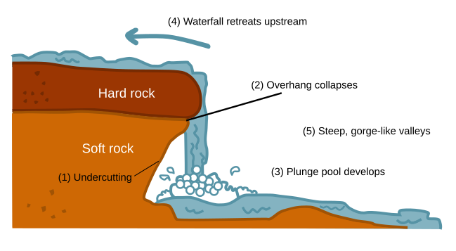
It is a 'plunge' class of waterfall Plunge Waterfall, where the water of the Kagawong River flows over. The river falls over a limestone bluff at Bridal Veil Falls. "Kagawong" means "mists rising from falling water" in the Ojibwe language.
.
It is a 'plunge' class of waterfall Plunge Waterfall, where the water of the Kagawong River flows over. The river falls over a limestone bluff at Bridal Veil Falls. "Kagawong" means "mists rising from falling water" in the Ojibwe language.
 .
Manitoulin island has an area of 2,766 km2 (1,068 sq mi). The island is physiographically part of Southern Ontario, an "eastward extension of the Interior Plains, a region characterized by low relief and sedimentary underpinnings". Manitoulin Island's soil is relatively alkaline. The Island is underlain by Ordovician and Silurian rocks - limestone, dolomite, and shales. The substrate is Precambrian rocks - specifically Early Proterozoic in age. Exposed at Sheguiandah, are ridges of white quartzite of the Bar River Formation. The island consists mainly of dolomite as it is a continuation of the Bruce Peninsula and Niagara Escarpment. This geological rock formation runs south into Niagara Falls and continues into New York. The island separates the larger part of Lake Huron to its south and west from Georgian Bay to its east and the North Channel to the north. Manitoulin Island itself has 108 freshwater lakes, some of which have their own islands; in turn several of these "islands within islands" have their own ponds. Manitou Lake, Mindemoya Lake and Kagawong Lake are the biggest and major lakes on the island. Kagawong Lake empties into the Kagawong River and then in turn into Mudge Bay.
.
Manitoulin island has an area of 2,766 km2 (1,068 sq mi). The island is physiographically part of Southern Ontario, an "eastward extension of the Interior Plains, a region characterized by low relief and sedimentary underpinnings". Manitoulin Island's soil is relatively alkaline. The Island is underlain by Ordovician and Silurian rocks - limestone, dolomite, and shales. The substrate is Precambrian rocks - specifically Early Proterozoic in age. Exposed at Sheguiandah, are ridges of white quartzite of the Bar River Formation. The island consists mainly of dolomite as it is a continuation of the Bruce Peninsula and Niagara Escarpment. This geological rock formation runs south into Niagara Falls and continues into New York. The island separates the larger part of Lake Huron to its south and west from Georgian Bay to its east and the North Channel to the north. Manitoulin Island itself has 108 freshwater lakes, some of which have their own islands; in turn several of these "islands within islands" have their own ponds. Manitou Lake, Mindemoya Lake and Kagawong Lake are the biggest and major lakes on the island. Kagawong Lake empties into the Kagawong River and then in turn into Mudge Bay.
450 million years ago Manitoulin was just south of the equator and a shallow tropical sea with extensive coral reefs. The waters where teaming with different life forms such as giant sea scorpions, squid-like creatures and trilobites which can now be found fossilized within the landscape. At Bridal Veils Falls you will be able for find some evidence of fossils in this limestone formation but please remember that as part of this trail they are protected and should not be collected.
Manitoulin formed about 450 to 425 million years ago, during what is known as the Ordovician and Silurian Periods. It is from the Middle and Upper Ordovician period of the Paleozoic era, fish appear, no land animals. Tan limestone (shale) is on Manitoulin Island and many of the small islands. Then 230 to 66 Million was the age of the Dinosaurs. 30,000 years ago was the beginning of the most recent glacial advance, the basins of what were to become the Great Lakes were sculpted. Around this time man migrated to North America. 10,000 was the end of the last Ice Age and the appearance of man in the area.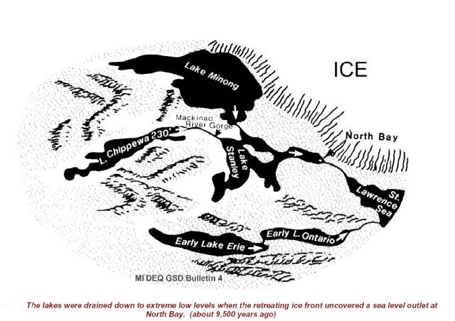
Lake Huron did not drain south through the Detroit River as it does now. Instead, the northern Great Lakes drained through a channel near present day North Bay and and down the Mattawa River to the Ottawa River Valley and on to the Saint Lawrence at Montreal. About 1,800 BC with the removal of the crushing weight of the ice, the land began to rebound slowly and unevenly and the Great Lakes stopped draining out through the Lake Nipissing area and switched to the St. Clare River. Georgian Bay still extended to Lake Nipissing. 
1,500 BC all this land is part of the Canadian Shield and is characterized by relatively poor rocky soil with lots of lakes and bogs.
Don't include the answers or photo's showing the answers in your log even in an encrypted form. Please EMAIL me the answers to be able to log this Earthcache.
If you find some evidence of fossils in this limestone formation or along the trail please remember that they are protected and should not be collected, but you would like to, please post any pictures of them here.
1. Standing on the top look out take an elevation reading and another below in front of the water fall and let me know the difference.
2. Using the above information. Describe in your words what is a "plunge" type waterfall.
3. Observing the plunge type waterfall. What is the thickness of the shale rock/hard rock that the water cascades over at the top?
4. Again observing the waterfall. What is the distance from the water that cascades over the falls to the soft rock/undercutting behind the waterfall at it's widest and how do you think this happens?
Optional: Photo's are optional. But if you choose to, no photo's that would give away any answers.

Additional Hints
(No hints available.)