English
Definitions:
Lagoons are shallow, often elongated bodies of water separated from a larger body of water by a shallow or exposed shoal, coral reef, or similar feature. Some authorities include fresh water bodies in the definition of "lagoon", while others explicitly restrict "lagoon" to bodies of water with some degree of salinity. The distinction between "lagoon" and "estuary" also varies between authorities.
Richard A. Davis Jr. restricts "lagoon" to bodies of water with little or no fresh water inflow, and little or no tidal flow, and calls any bay that receives a regular flow of fresh water an "estuary". Davis does state that the terms "lagoon" and "estuary" are "often loosely applied, even in scientific literature."characterizes lagoons as normally being elongated parallel to the coast, while estuaries are usually drowned river valleys, elongated perpendicular to the coast.
When used within the context of a distinctive portion of coral reef ecosystems, the term "lagoon" is synonymous with the term "back reef" or "backreef", which is more commonly used by coral reef scientists to refer to the same area. Coastal lagoons are classified as inland bodies of water.
In Latin America, the term “laguna”, which lagoon translates to, is often used to describe a lake, such as Laguna Catemaco. In Portuguese, “lagoa” may be a body of shallow sea water, but also a relatively small freshwater lake not linked to the sea.
"Lagoon" is derived from the Italian laguna, which refers to the waters around Venice, the Lagoon of Venice. Laguna is attested in English by at least 1612, and had been Anglicized to "lagune" by 1673. In 1697 William Dampier referred to a "Lagune or Lake of Salt water" on the coast of Mexico. Captain James Cook described an island "of Oval form with a Lagoon in the middle" in 1769.
Other examples of a Lagoon:
1. One of the largest Lagoon on the world is Lagoa dos Patos (10.145 km²) in Brasil in the near from Porto Alegre.
2. With 460 km² is the Lagoon from Lagos, in the east of the town with the same name. This lagoon is an example for by anthropogenic influences ecologically vulnerable lagoon. The pathogenic bacteria heavily polluted waters reached an average of only two meters deep and one of the largest lagoons in the African continent.
3. The Mar Menor is an approximately 170 km ² large salt water lagoon in the Spanish region of Murcia and the largest inland saline waters of Europe.
4. Very well known is the lagoon of Venice with the same lagoon city. The expansion reaches approximately 550 km ².
5. Also located on the Adriatic lagoon Karavasta in Albania, which is considered a major nature reserve.
6. Another important lagoon in the Mediterranean sea is the lagoon of Messolonghi (33.5 km ²) in the Messolonghi-Delta (Greece), the delta of the river Achelous. At the north end of the lagoon, the small town Aitoliko is located.
7. Ahunui as an example of a completely enclosed lagoon atoll islands.
8. The bay and lagoon of Walvis Bay is one of the largest bird sanctuaries in Africa; as well as the nearby lagoon of Sandwich Bay.
9. The 15,000 m² to the small lake of Prevelis jammed mouth of Megalopotamos on the beach of Prevelis.
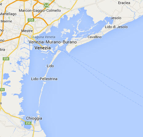
The Venetian Lagoon:
The Venetian Lagoon is the enclosed bay of the Adriatic Sea in which the city of Venice is situated. Its name in the Italian and Venetian language, Laguna Veneta – cognate of Latin lacus, "lake" – has provided the international name for an enclosed, shallow embayment of salt water, a lagoon.
The Venetian Lagoon stretches from the River Sile in the north to the Brenta in the south, with a surface area of around 550 square kilometres (210 sq mi). It is around 8% land, including Venice itself and many smaller islands. About 11% is permanently covered by open water, or canal, as the network of dredged channels are called, while around 80% consists of mud flats, tidal shallows and salt marshes. The lagoon is the largest wetland in the Mediterranean Basin.
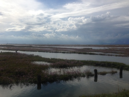
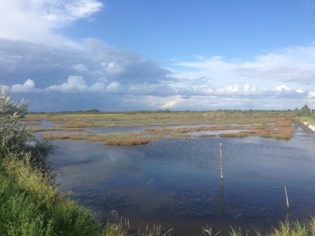
The northern part, such as Torcello mainly contains freshwater and is hardly reached by the tide. He therefore called laguna morta (dead lagoon). The saltwater lagoon, the water level falls with the tide, and rises and is flushed from the sea water, called laguna viva (living lagoon).
It is connected to the Adriatic Sea by three inlets: The Lido, Malamocco and Chioggia inlets. Sited at the end of a largely enclosed sea, the lagoon is subject to high variations in water level,[citation needed] the most extreme being the spring tides known as the acqua alta (Italian for "high water"), which regularly flood much of Venice.
The nearby Marano-Grado Lagoon, with a surface area of around 160 square kilometres (62 sq mi), is the northernmost lagoon in the Adriatic Sea and is called sometimes the "twin sister of the Venice lagoon.
The Lagoon of Venice is the most important survivor of a system of estuarine lagoons that in Roman times extended from Ravenna north to Trieste. In the sixth century, the Lagoon gave security to Romanised people fleeing invaders (mostly the Huns). Later, it provided naturally protected conditions for the growth of the Venetian Republic and its maritime empire. It still provides a base for a seaport, the Venetian Arsenal, and for fishing, as well as a limited amount of hunting and the newer industry of fish farming.
The Lagoon was formed about six to seven thousand years ago, when the marine transgression following the Ice Age flooded the upper Adriatic coastal plain. Deposition of river sediments compensated for the sinking coastal plain, and coastwise drift from the mouth of the Po tended to close tidal inlets with sand bars.
The present aspect of the Lagoon is due to human intervention. In the fifteenth and sixteenth centuries, Venetian hydraulic projects to prevent the lagoon from turning into a marsh reversed the natural evolution of the Lagoon. Pumping of aquifers since the nineteenth century has increased subsidence. Originally many of the Lagoon’s islands were marshy, but a gradual programme of drainage rendered them habitable. Many of the smaller islands are entirely artificial, while some areas around the seaport of the Mestre are also reclaimed islands. The remaining islands are essentially dunes, including those of the coastal strip (Lido, Pellestrina and Treporti).
Venice Lagoon was inhabited from the most ancient times, but it was only during and after the fall of the Roman Empire in the West that many people, coming from the Venetian mainland, settled in a number large enough to found the city of Venice. Today, the main cities inside the lagoon are Venice (at the centre of it) and Chioggia (at the southern inlet); Lido di Venezia and Pellestrina are inhabited as well, but they are part of Venice. However, the most part of the inhabitants of Venice, as well as its economic core, its airport and its harbor, stand on the western border of the lagoon, around the former towns of Mestre and Marghera. At the northern end of the lagoon, there is the town of Jesolo, a famous sea resort; and the town of Cavallino-Treporti.
The Earthcache and his place:
The cache is located in the northern part of the lagoon the so-called Valle Mesole, which gave its name to the village. The lagoon here is accessible via a narrow road that connects the villages of Lio Piccolo and Mesole.
To log this cache you must answered by email to the owner the following questions:
1. What kind of lagoon can you find here (dead or living lagoon) and how you realize that ?
2. How deep is the lagoon at the Location of this earthcache ?
The cache can be already logged without reply. Wrong answers or log entries without email will be deleted. It would be nice if you still would attach a picture of you and the lagoon to the log, but this is not a requirement to log the cache. Enjoy your stay in the Venetian Lagoon !
Deutsch
Allgemeine Erklärung zur Entstehung:
Eine Lagune ist ein Gewässer, das durch Sandablagerungen (Nehrung) oder Korallenriffe (Atoll) vom Meer abgetrennt ist.
Das Wort Lagune leitet sich über das italienische laguna vom lateinischen lacuna (Weiher, Lache) ab. In der Ostsee heißt die Lagune oftmals Haff bzw. Bodden, im Schwarzen Meer wird sie Liman genannt. Oft tragen Lagunen auch andere Namensteile wie See, Bucht oder Sound. Lagunen können durch Strandversetzung, die zur Bildung bzw. Verlängerung von Sandhaken und Nehrungen führt, vom Meer abgetrennt werden. Ist die Abtrennung vollständig, so entsteht aus der Lagune ein Strandsee, der langsam aussüßt. Wenn jedoch noch eine Verbindung zum Meer besteht, enthält die Lagune Brackwasser.
Im Falle der Lagunen von gehobenen Atollen kann es passieren, dass die Lagune zu einem kleinen See wird und wie im Falle der Buada-Lagune auf Nauru über einen Kilometer entfernt vom Meer liegt. Die Lagune kann auch wie im Falle von Niue gänzlich verschwinden; die übrig gebliebene Senke behält jedoch dann die Bezeichnung Lagune. Die Abgrenzung zu kleinen Binnenmeeren – Nebenmeere, die mit einem Ozean oder einem anderen Meer nur durch eine Meerenge verbunden sind – ist fließend, wobei flache Gewässer meist als Lagunen gelten..
Da Lagunen meist nur schlecht zugänglich sind, haben sie sich in vielen Fällen als von Menschen wenig beeinflusste Ökosysteme erhalten können. Diese Feuchtgebiete dienen dabei als wichtige Rückzugsgebiete von Wasservögeln, Fischen, kleineren Tieren und Pflanzen. Die ökologisch wichtigsten Lagunen werden international durch die Ramsar-Konvention geschützt.
Ein Beispiel einer – zumindest teilweise – erschlossenen und genutzten Lagune ist die Lagunenstadt Venedig in der Nähe der Mündung des Po in Italien. Grund für die Stadtgründung in Lagunen ist meist die sehr sichere Lage. Viele Lagunen sind außerdem sehr fischreich, was insbesondere in der Vergangenheit für die Bewohner der Umgebung von großer wirtschaftlicher Bedeutung war.
Weitere Beispiele von Lagunen:
1. Zu den weltweit größten Lagunen zählt der Lagoa dos Patos (10.145 km²) in Brasilien, an deren Ufer die Großstadt Porto Alegre liegt.
2. Die circa 460 km² große Lagune von Lagos liegt östlich der gleichnamigen Metropole und ist vielleicht das beste Beispiel für eine durch anthropogene Einflüsse ökologisch gefährdete Lagunenlandschaft. Das mit pathogenen Bakterien stark belastete Gewässer erreicht durchschnittlich nur zwei Meter Tiefe und zählt zu den größten Lagunen auf dem afrikanischen Kontinent.
3. Das Mar Menor ist eine rund 170 km² große Salzwasser-Lagune in der spanischen Region Murcia und das größte salzhaltige Binnengewässer Europas.
4. Sehr bekannt ist die Lagune von Venedig mit der gleichnamigen Lagunenstadt. Die Ausdehnung erreicht rund 550 km².
5. Ebenfalls an der Adria liegt die Lagune von Karavasta in Albanien, die als bedeutendes Naturschutzgebiet gilt.
6. Eine weitere bedeutende Lagune im Mittelmeer ist die Lagune von Messolongi (33,5 km²) im Messolongi-Delta (Griechenland), dem Delta des Flusses Acheloos. Am Nordende dieser Lagune liegt die kleine Stadt Aitoliko auf einer Insel, daran schließt sich die Lagune von Aitoliko an.
7. Ahunui als Beispiel einer vollständig von Atollinseln umschlossenen Lagune.
8. Die Bucht und Lagune der Walvis Bay ist eines der größten Vogelschutzgebiete Afrikas; ebenso die nahegelegene Lagune der Sandwichbucht.
9. Die zum 15.000 m² kleinen See von Preveli gestaute Mündung des Megalopotamos am Strand von Preveli.
Die Lagune von Venedig:
Die Lagune von Venedig ist ein durch Landzungen und Inseln weitgehend abgetrennter Meerbusen im Norden des Adriatischen Meeres. Sie entstand um 4000 v. Chr. durch Ablagerungen der Brenta und anderer die Poebene entwässernder Flüsse. In ihr liegt die Stadt Venedig.
Sie bedeckt eine Fläche von ca. 550 km². Rund 8 % der Lagunenoberfläche bestehen aus Inseln (darunter Venedig selbst und eine Reihe kleinerer Inseln), 11 % sind dauerhaft von Wasser bedeckt (inklusive der verschiedenen Kanäle), der Rest besteht aus den Fischgründen, sowie aus Watt- und Marschland.
Der nördliche Teil, etwa ab Torcello, enthält vorwiegend Süßwasser und wird vom Gezeitenwechsel kaum erreicht. Er heißt daher laguna morta (tote Lagune). Die Salzwasserlagune, deren Wasserstand mit Ebbe und Flut sinkt und steigt und die vom Meerwasser durchspült wird, heißt laguna viva (lebende Lagune).
Ohne weitere menschliche Eingriffe würde sich die Lagune in ein tiefes Wasserbecken verwandeln und die Sandbänke und Salzmarschen (Barene) darin verschwinden lassen. Dies hängt damit zusammen, dass ursprünglich kleine Flüsse in die Lagune mündeten, die die Republik Venedig direkt in die Adria umleiten ließ, um eine Verlandung zu verhindern. Damit erhielt sich die Stadt ihren Schutz durch das sie umgebende Wasser.
Doch kam dadurch nur noch wenig Sand, Schlick und Geröll in die Lagune, Material, das durch die Auslässe zur Adria langsam entwich. Diese Entwicklung wurde im 19. und 20. Jahrhundert dadurch verschärft, dass die Ausgänge für die erheblich angewachsenen Schiffe, vor allem der Industrieregionen um Mestre und Marghera, stark verbreitert und vertieft wurden. Fehlender Nachschub und verstärkte Erosion veränderten die Lagune stetig. So verliert die Lagune jedes Jahr rund 500.000 m³ Land.Verteidigungs- und Wirtschaftsmotive haben eine Situation geschaffen, die durch das Verschwinden von Salzmarschen, Sandbänken und Untiefen die Artenvielfalt bedroht.
Dabei schreitet die Verlandung des Nordens, der laguna morta, schneller voran. Hingegen wird das Wasserbecken im Süden, die laguna viva, immer tiefer und lebensfeindlicher. Während im Norden die Marschen wachsen, verschärft das regelmäßige Ausbaggern der Zufahrten, vor allem nach Mestre und Marghera, die Situation im Süden. Dazu kommt, dass Grundwasser abgepumpt wird, was den Lagunenboden weiter absenkt. Schließlich treten seit einigen Jahren Nahrungskonkurrenten auf, die inzwischen erhebliche ökonomische Bedeutung erlangt haben, wie die Philippinische Venusmuschel.
Hierbei reißen sogenannte Caparozzolante mit ihren Fangkörben den Lagunenboden auf und setzen damit eine Verschärfung des Materialverlusts in der Lagune in Gang, was durch ein relativ neues Phänomen der organisierten Kriminalität ermöglicht wird, welche solche Zerstörungen des Bodenbewuchses durch illegale Fischpraktiken in Kauf nimmt.
Dabei ist der Schutz durch den Pflanzenbewuchs von großer Bedeutung. In den Salzmarschen und auf den Sandbänken brechen Pflanzen die Kraft der Wellen und ihre Wurzeln halten den Boden fest. Algen- und Bakterienmatten sind geeignet, den Verlust von Sand und Schlick zu verlangsamen. Gerade ihre Zerstörung durch Muschelsammler verschärft die Materialverluste.
Schon jetzt sind Fluttore zum Schutz vor massiven Überschwemmungen beschlossen und im Bau, doch dies wird langfristig wahrscheinlich nicht genügen. Das winterliche Hochwasser in der Stadt (it. Acqua Alta) soll durch sie in den Höchstständen etwas gesteuert werden. Derzeit befindet sich das lange umstrittene MO.S.E-Projekt (für MOdulo Sperimentale Elettromeccanico), eine Art dreiteiliges Wasserstauwerk an den Ausfahrten der Lagune, in der Realisierung und soll spätestens 2016 fertiggestellt werden.
Die Lagune, wie sie heute besteht, ist ein Biotop aus Menschenhand, das unter Beibehaltung der derzeitigen Bedingungen in wenigen Jahrzehnten verschwunden sein wird. Daher wird derzeit darüber nachgedacht, einige Flüsse zumindest zeitweise in die Lagune zu entwässern, wobei künstliche Kanäle die Verteilung der Sedimente unterstützen könnten.
Immerhin hat Venedig dafür Sorge getragen, dass seine Kanäle ausgebaggert werden, doch gelangt immer noch eine große Menge an Fäkalien, Abfällen und vor allem gifthaltige Industrierückstände und Müll in die Lagune. Dazu kommen die zahlreichen Motorboote, die eine der Hauptursachen für die Belastung der Lagune mit ölhaltigen Resten darstellen.
Zum Earthcache und seinem Standort:
Der Standort befindet sich im nördlichen Teil der Lagune, dem sogenannten Valle Mesole, welches auch der gleichnamigen Ortschaft seinen Namen gab. Die Lagune ist hier über ein schmales Strässchen, welches die Ortschaften Lio Piccolo und Mesole verbindet erreichbar.
Um diesen Earthcache zu Loggen müssen folgende Fragen via Mail an den Owner beantwortet werden:
1. In welchem Teil der Lagune befindest du dich (lebende oder tote Lagune) und woran merkst du das ?
2. Wie hoch ist der Wasserstand der Lagune am Standort des Earthcaches ?
Der Cache kann auch ohne Rückantwort bereits geloggt werden. Falsche Antworten oder Logeinträge ohne Mail werden gelöscht. Es wäre schön, wenn du dem Log noch ein Bild von dir und der Lagune anhängen würdest, ist jedoch keine Bedingung. Geniesse weiterhin den Aufenthalt in der Lagune von Venedig !
Italiano
Descrizione:
Le lagune tendono a formarsi in territori pianeggianti e solitamente interessati da foci a delta dei fiumi e vengono classificate in lagune vive e lagune morte. Le lagune vive hanno uno o più collegamenti o sbocchi con il mare aperto che permettono il naturale passaggio dell'acqua marina.
Le lagune morte invece sono completamente circondate da terraferma e non hanno sbocchi sul mare, è solo attraverso l'innalzamento dell'acqua di mare dovuto alle maree che l'acqua marina entra all'interno delle lagune morte per poi defluire con l'abbassamento delle maree.
Le lagune morte sono diffuse principalmente nelle zone oceaniche dove l'effetto delle maree può alzare il livello dell'acqua di mare anche di alcuni metri, questo permette l'entrata dell'acqua marina nella laguna e la fuoriuscita all'abbassarsi della marea.
Le lagune morte non possono essere confuse con gli stagni di acqua salmastra perché oltre alla bassa profondità degni stagni ed al loro basso contenuto di ossigeno disciolto in acqua, essi differiscono dalle lagune proprio perché negli stagni d'acqua salmastra non si verifica il naturale passaggio d'acqua dovuto alle maree e l'acqua stagnante non presenta quindi un naturale innalzamento e un successivo naturale abbassamento ma rimane di altezza costante.
Molte lagune in Italia in passato sono state trasformate in stagni salmastri. Questo fu fatto per favorire la nascente industria del sale creando delle saline o semplicemente per itticoltura. Per trasformare una laguna viva in uno stagno di acqua salmastra l'uomo chiudeva gli sbocchi che essa aveva con il mare, mentre nel caso delle lagune morte l'uomo sollevava semplicemente il bordo esterno della laguna morta che confinava con il mare in modo da evitare che le maree portassero l'acqua al suo interno.
Per evitare che la laguna si prosciugasse e per creare nuovo sale per la salina venivano costruiti dall'uomo, sia nel caso delle ex lagune vive che in quello delle ex lagune morte, degli sbocchi artificiali chiusi da paratoie. Così facendo l'acqua non entra più liberamente ed in modo naturale ma è l'uomo che artificialmente aprendo le paratoie decide in modo artificiale di fare entrare l'acqua nello stagno salmastro.
Questo avviene quando l'uomo ha bisogno di creare nuovo sale per le saline o ha bisogno di catturare i pesci dello stagno salmastro, in quanto i pesci vanno contro corrente se vengono aperte le paratoie e tendono quindi ad uscire dallo stagno salmastro.
Essi possono essere facilmente catturati dai pescatori tramite reti poste prima dello sbocco artificiale creato dall'uomo. Non si sa ancora con esattezza il numero totale delle lagune italiane che nei tempi storici sono state trasformate in stagni salmastri.
Un tipo particolare di laguna, caratterizzata dalla presenza di acqua salmastra, è lo Haff, tipica delle coste del mar Baltico.
Di particolare interesse è la quantità di esseri viventi animali e vegetali che questo ambiente di transizione riesce ad ospitare: oltre alle specie diffuse in acque dolci e salate qui si trovano anche specie di rara diffusione, localizzate solo in ambienti similari. Per questo motivo molte lagune sono sotto la protezione di enti per la salvaguardia della natura o sotto diretta tutela di province, Regioni o nazionale.
La laguna è un territorio estremamente delicato: l'equilibrio biologico rischia infatti di rompersi soprattutto se l'uomo modifica le caratteristiche fisiche del luogo (dirottamento di fiumi che vi sfociano, costruzione di moli, chiusura di eventuali sbocchi sul mare) o, indirettamente, per i suoi rifiuti (rischio di eutrofizzazione).
Esempi di lagune:
1. Più grandi lagune del mondo di Lagoa dos Patos è uno dei (10145 km ²) in Brasile, nella città di Porto Alegre si trova sulla riva.
2. I circa 460 km ² laguna di Lagos si trova ad est della città con lo stesso nome ed è forse il miglior esempio di un pericolo ecologico da influenze antropiche laguna. I batteri patogeni acque fortemente inquinate raggiunto una media di soli due metri di profondità e una delle più grandi lagune del continente africano.
3. Il Mar Menor è un 170 km ² grande laguna di acqua salata nella regione spagnola di Murcia e le maggiori interne acque saline in Europa.
4. Molto noto è la laguna di Venezia con la stessa città lagunare. L'espansione raggiunge circa 550 km ².
5. Anche sulla costa adriatica è la laguna di Karavasta in Albania, che è considerato un importante riserva naturale.
6. Un altro laguna importante del Mediterraneo è la laguna di Missolungi (33,5 km ²) nel Messolonghi-Delta (Grecia), il delta del fiume Acheloo. All'estremità nord della laguna, la piccola cittadina Aitoliko situato su un'isola, è la laguna di Aitoliko collega.
7. Ahunui come un esempio di completamente recintato isole della laguna atollo.
8. La baia e la laguna di Walvis Bay è uno dei più grandi santuari di uccelli in Africa; così come la vicina laguna di Sandwich Bay.
9. Di 15.000 m² lago di Prevelis inceppato bocca Megalopotamos sulla spiaggia di Prevelis.
Laguna di Venezia:
La Laguna di Venezia o Laguna veneta è una laguna del Mare Adriatico settentrionale, lungo le coste del Veneto.
La superficie della laguna è di circa 550 km², di cui l'8% sono occupati da terra (Venezia stessa e le molte isole minori). Circa l'11% è permanentemente composto d'acqua, o canali dragati, mentre circa l'80% sono piane di marea fangose, paludi d'acqua salata o le artificiali casse di colmata.
È collegata al Mar Adriatico da tre bocche di porto. Nell'ordine, da nord: 1. Lido-San Nicolò, 2. Malamocco, 3. Chioggia.
Essendo situata all'estremità di un mare chiuso, la laguna è soggetta a grandi escursioni del livello delle acque, le più vistose delle quali (soprattutto nei periodi autunnali e primaverili) provocano fenomeni come l'acqua alta, che allaga periodicamente le isole più basse, o l'acqua bassa, che rende talvolta impraticabili i canali meno profondi. Per agevolare la navigazione, i canali lagunari sono segnalati attraverso file di pali: le bricole. L'accesso al mare in futuro dovrebbe essere regolato dalle colossali opere del progetto MoSE.
Nella zona centro-settentrionale della laguna sorge la città di Venezia, a 4 km dalla terraferma e 2 dal mare aperto. Si estende inoltre ampiamente sull'immediata terraferma con la conurbazione di Mestre-Marghera-Favaro Veneto.
All'estremità meridionale sorge invece la città di Chioggia, mentre all'estremità orientale i piccoli centri compresi nel comune di Cavallino-Treporti, lungo il litorale Cavallino.
A marzo 2008, nel centro storico di Venezia si contavano 60.680 abitanti e nelle isole dell'estuario 30.568. Se a questi si aggiungono gli abitanti del centro storico di Chioggia (circa 20.000), si può arrivare a dire che sulle isole della Laguna vivono grossomodo 110.000 abitanti. Non si tiene però conto dei 10.000 abitanti del comune di Cavallino-Treporti, dei quali una buona parte vivono a tutti gli effetti in Laguna.
L'attività umana ha profondamente modificato l'aspetto e l'equilibrio idro-geografico della laguna, fin dall'epoca dei primi insediamenti: nel corso dei secoli le bocche di porto, inizialmente più numerose, sono state ridotte alle attuali tre, i cordoni sabbiosi (i lidi) che separavano la laguna dal mare sono stati rinforzati e stabilizzati con le poderose opere dei Murazzi (lunghissime dighe settecentesche in pietra d'Istria poste a difesa del perimetro esterno lagunare), mentre le foci dei fiumi Sile, Piave e Brenta sono state deviate al di fuori della gronda lagunare per prevenirne l'interramento. Questo ha spesso compromesso l'antico equilibrio, comportando anche la decadenza di numerosi centri abitati, quali Torcello, Costanziaco e Ammiana.
Ancora oggi la laguna fornisce un'ottima base per il porto di Venezia (commerciale ed industriale) e per quello di Chioggia (commerciale e peschereccio) e per l'Arsenale della Marina Militare e per diverse attività riguardanti la cantieristica navale (a Venezia, Marghera, Chioggia e Pellestrina), oltre che la cantieristica minore e da diporto.
La laguna è inoltre un ambiente adatto per la pesca, oltre che per una quantità limitata di caccia e per la nuova industria dell'allevamento ittico. Tipiche abitazioni della laguna sono tuttora i casoni, costruzioni in legno e canne di palude, utilizzati come rifugio per i pescatori che un tempo vivevano in queste zone.
Alcune delle isole più piccole sono interamente artificiali, mentre gran parte delle aree attorno al porto di Marghera sono esito di massicce attività di bonifica. Sabbiose sono invece le grandi isole della striscia costiera (Lido, Pellestrina e Treporti). Le isole rimanenti sono in pratica degli affioramenti più o meno consistenti e più o meno stabili denominate barene, motte o velme.
La progressiva erosione della laguna, processo che comporta la scomparsa di ampie superfici coperte da velme e barene e, in generale, l'abbassamento dei fondali ed il livellamento delle differenze morfologiche interne, associato ad una costante perdita di sedimenti dalle bocche di porto ben superiore agli input dal bacino scolante, e l'inquinamento conseguente alla città, al porto e alle immissioni d'acqua dal bacino scolante, sono solo alcuni dei problemi che assillano questo ecosistema unico al mondo, riconosciuto dall'UNESCO insieme alla città, Patrimonio dell'Umanità
D'altra parte il progetto MO.S.E. per la costruzione di una sorta di diga mediante l'innalzamento di paratoie mobili flottanti dinanzi alle tre uscite verso il mare, allo scopo teorico di contrastare i fenomeni estremi di inondazione che vanno sotto il nome di acqua alta, costituisce un ulteriore fattore di rischio ambientale per la laguna, limitando in fase operativa il ricambio di ossigeno del corpo idrico, già molto limitato.
La zona di porto Marghera ha visto negli anni la creazione di un'ampia zona industriale (30000 occupati nel 1983) con la creazione di industrie pesanti quali canteristica navale, centrali termoelettriche, industrie di fertilizzanti e impianti petrolchimici. Annualmente[non chiaro] il traffico marittimo (circa 400 navi) rappresenta più di 10 milioni di tonnellate di prodotti petroliferi, di cui 5,8 milioni di tonnellate di greggio[senza fonte]. Per molti anni, prima di severe normative ambientali, gli scarichi sono sempre pervenuti in laguna senza trattamenti preliminari a causa di ritardi tecnologici e elevati costi.
Nel 1983 ad esempio la laguna risultava nel complesso moderatamente inquinata. In particolare si riscontrava una presenza elevata di metalli pesanti nella sua porzione centrale, con concentrazioni critiche di mercurio, rame, cadmio e piombo ma non di nichel, cromo e cobalto. Gli inidcatori dell'inquinamento organico mostravano una COD elevata nella porzione sud-ovest e inusualmente bassa nella zona centrale, mentre la distribuzione di azoto totale risultava massima e a livelli fuori norma a Sud-Ovest e Nord-Est.
La Terra e la sua posizione:
Il sito si trova nella parte settentrionale della laguna, nella parte morta della laguna (laguna morta), la cosiddetta Valle Mesole, che è anche la città dello stesso nome suo ha dato nomi. La laguna qui è accessibile tramite una stretta strada che collega i villaggi di Lio Piccolo e Mesole.
Per registrare questa cache va risolta al Proprietario alle seguenti domande via e-mail:
1. Che tipo di laguna che potete trovare qui e come realizzare il ?
2. Quanto profonda è la laguna in questa posizione ?
La cache può essere già registrata senza risposta. Verranno eliminati risposte sbagliate o voci di registro senza email. Sarebbe bello se ancora volesse allegare una foto di voi e la laguna nel registro, ma non è un requisito. Godetevi continua a rimanere nella laguna di Venezia !