 For 100 years, the National Park Service has preserved America’s special places “for the enjoyment, education, and inspiration of this and future generations.” Celebrate its second century with the Find Your Park GeoTour that launched April 2016 and explore these geocaches placed for you by National Park Service Rangers and their partners.
geocaching.com/play/geotours/findyourpark
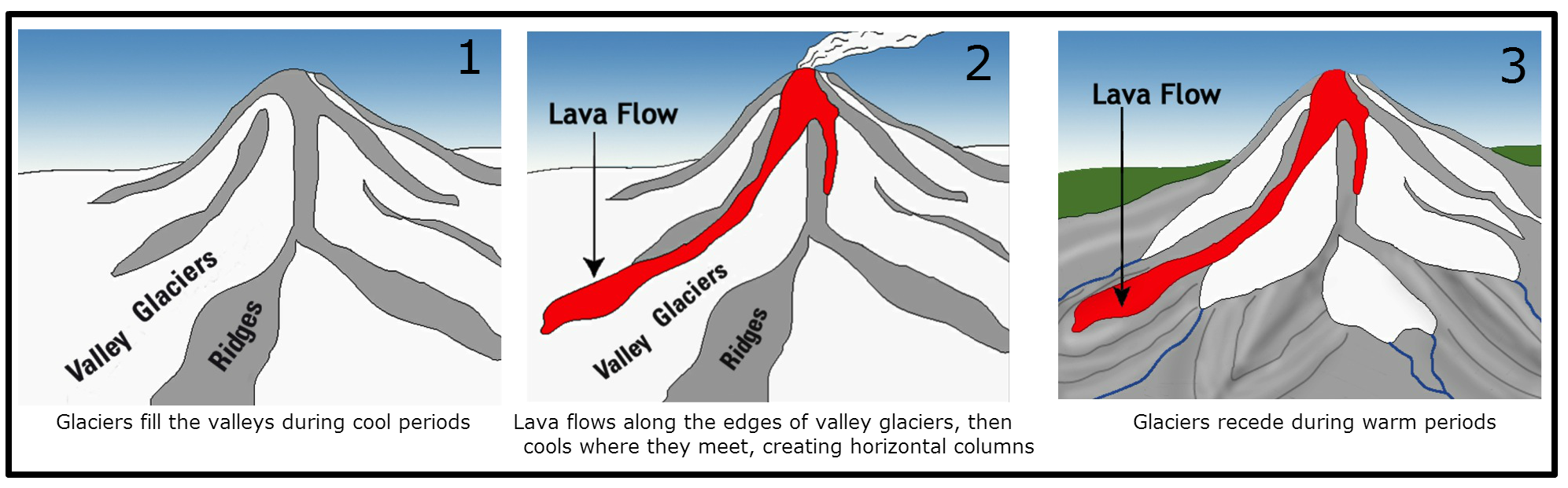
The lava you see here erupted about 500 thousand years ago, at the very beginning of the main cone-building phase of modern Mount Rainier. This corner of the lava flow contains spectacular columns that provide clues about their origin.
Parking: There is a large pullout at the posted coordinates. Please park there and don't cross the road, the columns are on a blind curve.
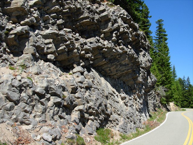
Volcanic columns are a result of cooling in a thick lava flow. As lava cools, it decreases in volume. Since the whole lava flow cannot expand and contract easily, cracks form. The columns are usually hexagonal (6-sided), but polygons with 3 to 12 or more sides have been observed. A rock that cools evenly will likely form hexagons, while uneven cooling makes different shapes. Large columns are the result of slower cooling, while small columns result from faster cooling. The columns at Devils Tower in Wyoming are 7 feet wide!
The columns here are unusual because they are horizontal instead of vertical. This tells us that the cooling surface was not up, but to the side. A quick look at the glaciated slopes of Mount Rainier reveals the likely reason; as the lava flowed down the slopes of the mountain, it clashed with glaciers already in place. The glacial ice caused the lava to cool faster on its sides than on its top.
In order to log this earthcache, please email me following information:
1. Count the number of sides on 20 columns. Add all the sides together and divide by 20 to get the average number of sides.
2. Does the average column have six sides? If not, how many?
3. Based on the above answer, did the lava cool evenly?
4. Approximately how wide are the columns (the diameter)?
5. Based on their width, do you think they cooled rapidly or slowly?
Optional: Post a photo of your group at "the battleground!"
Please don't post the answers in your online log. Logs may be deleted if not accompanied by an email.
Further reading:
Goehring, L., Morris, S., 2008, Scaling of columnar joints in basalt, Journal of Geophysical Research: Solid Earth, v. 113, B10203, p. 1-18.
Pringle, Patrick T., 2008, Roadside geology of Mount Rainier National Park and vicinity: Washington Division of geology and Earth Resources Information Circular 107, 190 p.
Stockstill, K., Vogel, T., Sisson, T., 2003, Origin and emplacement of the andesite of Burroughs Mountain, a zoned, large-volume lava flow at Mount Rainier, Washington, USA, Journal of Volcanology and Geothermal Research, v. 119, p. 275-296.