When I first walked here, in search of nearby traditional caches, I did not realize the geological significance of this feature.
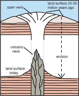
It is a volcanic plug, also called a volcanic neck or lava neck, is a volcanic landform created when magma hardens within a vent on an active volcano. When present, a plug may cause an extreme build-up of pressure if rising volatile-charged magma is trapped beneath it, and this can sometimes lead to an explosive eruption. Effectively the " bottle neck", (crater walls), has been eroded away over milions of years and the "cork" remains
There are two British examples of building on a volcanic plug are the Castle Rock in Edinburgh, Scotland; and here at Deganwy
This "Dark Age" fortress, which is now little more than ditches and mounds, was formerly made of wood and constructed on a massive rock outcrop in what is now the suburbs of modern Llandudno
Traditionally, it was the headquarters of Maelgwn Gwynedd King of Gwynedd (520–547). A nearby hill is called Bryn Maelgwyn and other places in the locality are associated with him. An important coin hoard of 204 Silver Cnut Pennies were found here in July 1979.
The geology of north-east Wales tells a 500 million year story of deep-sea muds crumpled and fractured by earth-movements, shallow tropical seas teeming with life, swamps with giant mosses, vast hot and barren deserts periodically inundated by flash floods and, in the relatively recent past, vast ice sheets sculpting the landscape.
These changing environments have led to the formation of a variety of rock types, which have had a major influence on the shape of the landscape.
Continental drift has seen Wales gradually work its way northwards to its present position, sometimes incorporated into huge supercontinents that no longer exist. It now lies close to the western margin of the Eurasian Plate of continental crust. This movement or orogeny results in cracks or fault that allows deep magma to come to the surface. When the oldest rocks exposed at surface in north-east Wales were deposited, Wales, as a part of the ancient micro continent of East Avalonia, was situated deep in the Southern Hemisphere.
Igneous, volcanic, extrusive rock often formed when volcanic arcs are sub ducted under the continental shelf.
Extensive erosion and lowering of land surface since then has removed the exterior of the volcanic cone and the surrounding softer rocks. As the volcanic mountain cooled, the remaining PLUG forms the interesting vertical column that can be seen today.)
This plug was formed in the beginning of the Late Ordovician, from 460 to 450 million years ago, when volcanoes spewed massive amounts of carbon dioxide into the atmosphere, turning the planet into a hothouse.
The plug is composed of a lighter rock, rhyolite which is an igneous volcanic silica rich rock of felsic composition (typically > 69% SiO2). It may have a variety of textures. Felsic eruptions from stratovolcanoes are more commonly explosive. These explosive eruptions are a function of the high viscosities and high gas contents of rhyolitic magmas.
Rhyolite can be considered as the extrusive, (pushed out of the earth and formed closer to the surface and cooling quickly.), similar to granite in chemical composition, but granites are formed deep in the earth and retained there, cooling slowly. Consequently, outcrops of rhyolite may bear a resemblance to granite. Because of t their high content of silica and low iron and magnesium contents, rhyolite melts are highly polymerized and form highly viscous lavas
Rhyolites cool too quickly to grow larger crystals. Lava flows slowly, like tooth paste squeezed out of a tube, and tends to pile up and form lava domes. Viscous rhyolitic lavas generally ooze out of the volcano's central vent; to form symmetrical lava domes. In some cases, however, asymmetric flow down one side of the vent can produce an elongated extrusion, called a coulee or a dome flow. Here however you are standing on a rhylotile 'PLUG' or 'neck' which cooled and solidified to block an ancient volcano vent. Not the crater exactly, but the floor with the side walls the eroded away
i.e. the "cork in a bottle", which stopped an ancient eruption
Acknowledgements
Notes on the Geology of Deganwy and its neighbourhood, 68. — C. E. Miles. The Mersey Estuary, 85. — J. Wilding.
To claim this earth cache.
Please EMAIL. me the answers ~ From the guidelines: You do not need to wait for permission to log. Requiring someone to wait is not supported by the EarthCache guidelines.
You should send your logging task answers , then log the EarthCache. When I review your logging task answers, if there is a problem, I will contact you to resolve it. If there is no problem, then your log simply stands. However, I will email you to let you know your answers were OK.
Don't include the answers in your log even in an encrypted form
Questions
1. Describe the colour and texture of ANY of the rocky outcrops nearby, How big are the flecks – crystals? (HINT; Use the cache notes as a guide.)
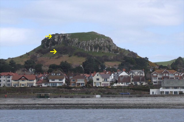
2. You are at a height of approximately 100m above sea level. On the western side, HOW FAR DOWN, in terms of height can you see less steep rock which may be remnants of the cone?(HINT; Look at the diagram and use the yellow arrows in the photo to help you.)
3. IGNORING the little hole near you (about 10m across), estimate the diameter, by paces, of the volcanic pipe which this plug choked.(HINT; its large extent really clear, if you check on the satellite view or even the picture, before you visit)