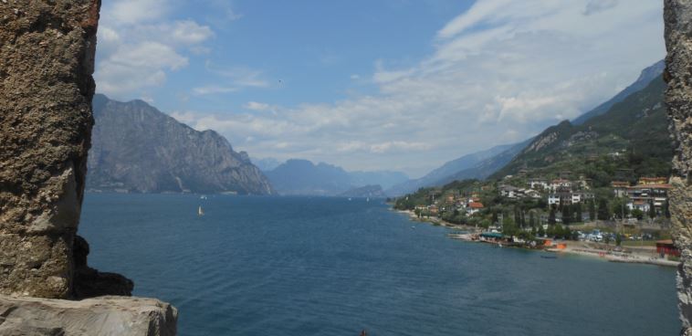

Lago di Garda
Il lago si trova tra le Alpi a nord e la pianura padana a sud. Il nord del lago appartiene alla regione Trentino-Alto Adige, la Lombardia ad ovest e l'est del Veneto. Così, le tre province di quota Trentino (a nord), Verona (est) e Brescia (West) amministrazione.
Le sponde settentrionali del lago è circondato da cime di duemila metri delle montagne di Lago di Garda, come il Monte Baldo; la banca meridionale è già nel piano. Lago di Garda è il più grande lago d'Italia. Il lago è lungo circa 52 km e larga 2,5-17 km. Al suo punto più profondo misura circa 352 m. Anche se vi è un lago di montagna, è solo circa 70 m sopra il livello del mare. L'area è di 370 chilometri quadrati. Il lago è alimentato principalmente dal fiume Sarca. Questo scorre sul lato nord vicino Torbole nel lago. Il fiume Mincio lascia il Lago di Garda a Peschiera del Garda e sfocia nel Po in seguito.
L’evoluzione del Lago di Garda
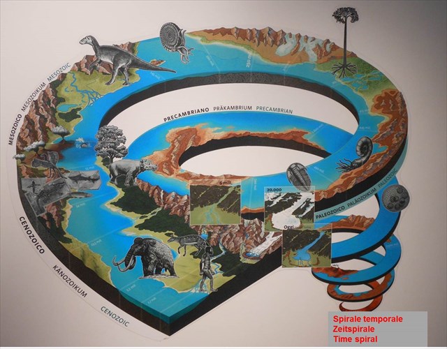
La conca benacense prende origine dalle attività tettoniche che si sono attivate nel Mesozoico, era geologica iniziata circa 250 millioni di anni fa. Questi movimenti della crosta terrestre hanno determinato una depressione tettonica. Ca. 200 millioni di anni fa, l’area faceva parte del fondale marino dell’antico oceano della Tetide che si estendeva, da Est verso Ovest per oltre 5000 km.
Circa 35 millioni di anni fa, ebbe inizio il sollevamento del fondale marino della Tetide e dell’attuale area gardesana che portò alla chiusura e conseguente scomparsa dell’antico mare. Ciò avvenne a seguito dello “scontro” tra la placca continentale africana e quella euroasiatica che determinò l’origine delle Alpi e Apennini. La fossa benacense ebbe origine in seguito alle profonde erosioni che circa 6 millioni di anni fa interessarono l’intera area alpina e che incisero un canyon fluviale profondo oltre 500 m sotto il livello attuale del mare. L’odierno aspetto dell’area gardesana risale, però, a tempi ben più recenti quando, a partire da ca. 1.5 millioni anni fa ( Quaternario ), si alternarono numerose espansioni del ghiacciaio del Garda.
Le rocce – diverse per origine
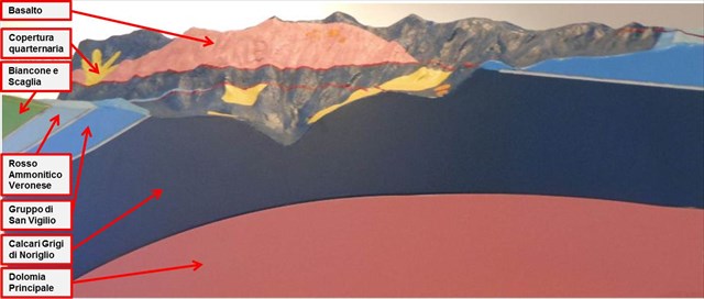
Nella conca benacense affiorano numerosi tipi di rocce che appartengono a tre diversi gruppi, distinti sulla base della loro origine: rocce magmatiche, sedimentarie e metamorfiche.
Le rocce magmatiche si formano per il raffredamento di magmi sia in profondità che in superficie. Costituiscono la quasi totalità della crosta terrestre. Sono prive di fossili, ma contengono stupende associazioni cristalline. Le rocce più comuni sono il GRANITO, il PORFIDO e il BASALTO.
Le rocce sedimentarie si formano sulla superficie terrestre per opera degli agenti esterni ( aqua, vento, ghiaccio, ecc) e, in ambiente marino, gerneralmente per precipitazione di fanghiglie calcaree. Queste rocce sono le più diffuse poiché coprono oltre l’80% della superficie terrestre. La DOLOMIA e i CALCARI sono le rocce sedimentarie più note. I calcari spesso contegono numerosi fossili.
Le rocce metamorfiche sono rocce magmatiche o sedimentarie che hanno subìto trasformazioni strutturali, mineralogiche e chimiche dovute all’effetto della temperature, della pressione e dei fluidi circolanti nelle rocce. Generalmente sono prive di fossili. Esempi comuni sono: QUARZITE, SCISTI, GNEISS e Marmo.
I fossili – testimoni del passato
I fossili più antichi della sponda veronese del Lago di Garda risalgono all’era mesozoica (periodo Triassico, circa 250-200 millioni di anni fa). Si tratta prevalentemente di organismi marini vissuti nell’antico mare della Tetide, un habitat simile ad un mare. 
Solo una piccolissima parte degli organismi vissuti nel passato si è conservata all’interno delle rocce sotto forma di fossili. Per il processo di fossilizzazione è fondamentale che un organismo dopo sua la morte, prima ancora che abbiano inizio i processi di decomposizione, sia ricoperto rapidamente da sedimenti fini. Alcuni fossili hanno avuto una vita relativamente breve, ma un’ampia diffusione geografica. Questi importanti organismi del passato, noti come “fossili guida” indicano con precisione l’età degli strati di roccia in cui sono conservati. Tra i più comuni nell’area gardesana ricordiamo le ammoniti e molti foraminiferi ( p. es. Globotruncana).
Per loggare questa cache inviatemi le risposte ai seguenti quesiti e postate una foto di voi (o del vostro GPS)
1.) Quali sono rocce composte principalmente da sponda veronese del lago di Garda con il Monte Baldo?
2.) All'uscita del museo a N45° 45.975 E010° 48.507 troverete due ammoniti. Determinare il diametro delle ammoniti più grandi.
3.) Andare ora al lago per N45° 45.997 E010° 48 531. Vi si può trovare una parete di roccia sotto il balcone del castello. Descrivere la struttura e apprezzare l'altezza.
In seguito potete immediatamente loggare. Se qualche cosa non è corretto, vi contattiamo.

Der Gardasee
Der Gardasee liegt zwischen den Alpen im Norden und der Po-Ebene im Süden. Der Norden des Sees gehört zur Region Trentino-Südtirol, der Westen zur Lombardei und der Osten zu Venetien. Damit teilen sich die drei Provinzen Trentino (Norden), Verona (Osten) und Brescia (Westen) die Verwaltung.
Das nördliche Ufer des Sees ist von Zweitausendern der Gardaseeberge wie z. B. dem Monte Baldo umsäumt; das südliche Ufer liegt bereits in der Ebene. Der Gardasee ist der größte See Italiens. Der Gardasee ist etwa 52 km lang und zwischen 2,5 und 17 km breit. An seiner tiefsten Stelle misst er etwa 352 m. Obwohl es sich um einen Bergsee handelt, liegt er nur etwa 70 m über den Meeresspiegel. Die Fläche beträgt 370 Quadratkilometer. Der Gardasee wird hauptsächlich durch den Fluss Sarca gespeist. Dieser fließt am Nordende bei Torbole in den See. Als Mincio verlässt der Fluss bei Peschiera del Garda den Gardasee und fließt später in den Po.
Die Entstehung
Das Gardaseebecken entstand durch Bewegungen der Erdkruste im Mesozoikum, einer geologischen Ära, die vor 250 Millionen Jahren begann. Dadurch bildete sich eine tektonische Senke. Vor 200 Millionen Jahren gehörte das Gebiet zum Meeresboden des Urmeeres Tethys, das sich auf der Erde in Ost-West Richtung auf einer Länge von über 5000 km ausbreitete.
Vor etwa 35 Millionen Jahren begann sich der Boden des Urmeeres Tethys zu heben, das schließlich vollständig verschwand. Auslöser für die Hebung des Meeresbodens war das „aufeinanderprallen“ der afrikanischen und der eurasischen Kontinentalplatten. Dabei bildeten sich die Alpen und der Apennin. Die Gestaltung des Gardaseebeckens geht auf mächtige Erosionsprozesse zurück, die vor etwa 6 Millionen Jahren das gesamte Alpengebiet betrafen. Damals bildete sich eine Geländespalte, die bis in eine Tiefe von 500 m unterhalb des derzeitigen Meeresspiegels reicht. Das heutige Aussehen des Gardaseebeckens ist das Ergebnis weit jüngerer Ereignisse. Während des Quartärs vor etwa 1,5 Millionen Jahren reichten die Eiszeitgletscher mehrmals bis in den Gardaseeraum und formten die Geländeoberfläche.
Das Gestein – Der Ursprung macht den Unterschied
Im Gardaseebecken finden sich zahlreiche Gesteinsarten, die zu ihrer unterschiedlichen Entstehung nach zu drei Gesteinsgruppen gehören: magmatische Gesteine, Sedimentgesteine und metamorphe Gesteine.
Die magmatischen Gesteine entstehen beim Abkühlen von Magma. Dieser Prozess kann sowohl im Erdinneren, als auch an der Erdoberfläche erfolgen. Nahezu die gesamte Erdkruste besteht aus magmatischem Gestein. Es enthält zwar keine Fossilien aber kristalline Einschlüsse. Zu den bekanntesten Magmagesteinen zählen GRANIT; PORPHYR und BASALT.
Die Sedimentgesteine bilden sich an der Erdoberfläche durch äußere Einwirkungen wie Wasser, Wind und Eis, oder am Meeresgrund durch Ablagerung von kalkhaltigem Schlamm. Sedimentgesteine bilden 80% der Erdoberfläche. Zu den bekanntesten Vertretern zählen DOLOMITGESTEIN und KALKSTEIN. Kalkgesteine enthalten zahlreiche Fossilien.
Bei metamorphen Gesteinen handelt es sich um Sedimentgesteine oder magmatische Gesteine, die nach ihrer Entstehung durch die Einwirkung von Temperatur, Druck oder Flüssigkeiten in ihrer mineralogischen, chemischen oder strukturellen Zusammensetzung verändert wurden. Normalerweise enthalten sie keine Fossilien. Zu dieser Gesteinsgruppe zählen QUARZIT, SCHIEFER, GNEISS und MARMOR.
Zeugen der Vergangenheit
Die ältesten Fossilien auf der Veroneser Seite des Gardasees stammen aus dem Mesozoikum ( Trias-Periode, 250-200 Millionen Jahre). Es handelt sich hauptsächlich um Meeresorganismen, die in der Tethys lebten.
Der Lebensraum in diesem Urmeer entsprach den Bedingungen, die in den heutigen Tropenmeeren herrschen. Nur sehr wenige der vorgeschichtlichen Organismen haben sich als versteinerte Fossilien erhalten. Voraussetzung dafür ist, dass ein Lebewesen unmittelbar nach seinem Absterben und noch bevor die Verwesung einsetzt von feinen Sedimenten überlagert wird. Die anschließende Umwandlung eines lebenden Organismus in ein Fossil kann mehrere Millionen Jahre dauern. Einige der zu Fossilien versteinerten Organismen lebten während einer sehr kurzen Zeitspanne und besaßen ein weites Verbreitungsgebiet. Diese „Leitfossilien“ eignen sich gut zur Datierung der Gesteinsschichten in denen sie vorkommen. Zu den wichtigsten Leitfossilien im Gardaseeraum zählen die Ammoniten und viele Foraminiferen ( z.B. Globotruncana).
Bitte macht optional ein Foto von euch ODER eurem GPS (mit sichtbaren Koordinaten) und fügt es eurem Log-Eintrag hinzu.
Außerdem schickt mir eine Mail mit folgenden Angaben:
1.) Aus welchen Gesteinen besteht vor allem die Veroneser Seite des Gardasees mit dem Monte Baldo?
2.) Am Ausgang des Museums bei N45° 45.975 E010° 48.507 findet ihr zwei Ammoniten. Bestimme den Durchmesser des größeren Ammoniten.
3.) Begebt euch nun an den See zu N45° 45.997 E010° 48.531. Dort findet ihr eine Gesteinswand unterhalb des Balkons der Burg. Beschreibe deren Struktur und schätze die Höhe.
Danach könnt Ihr sofort loggen. Wenn irgendetwas nicht in Ordnung sein sollte, melden wir uns.

Lake Garda
The lake lies between the Alps in the north and the Po valley in the south. The north of the lake belongs to the region of Trentino-Alto Adige, Lombardy to the west and the east to Veneto. The three provinces of Trentino (north), Verona (east) and Brescia (West) share the administration.
The northern of the lake is surrounded by twothousend meters peaks of the Lake Garda mountains, such as Monte Baldo; the southern bank is already in the plane. Lake Garda is the largest lake in Italy. The lake is about 52 km long and 2.5 to 17 km wide. At its deepest point it measures about 352 m. Although there is a mountain lake, it is only about 70 m above the sea level. The area is 370 square kilometers. The lake is mainly fed by the river Sarca. This flows on the north end near Torbole in the lake. When leaving the Mincio River at Peschiera del Garda Lake Garda and flows into the Po later.
The origin
The Garda basin originated as a result of tectonic shifts in the Mesozonic era, a geological era that began 250 million years ago. These movements of the earth’s crust formed a tectonic depression. 200 million years ago, the area formed part of the floor of the ancient Tethys Ocean, wich extended over 5,000 km from east to west.
Approximately 35 million years ago, the bottom of the ancient Tethys Ocean began to rise, with the sea finally disappearing completely. The cause of the sea floor rising was the “clash” of the African and Eurasian continental plates, leading to the formation of the Alps and the Apennines. The emergence of the Garda basin originates in The powerful erosion process that affected the entire Alpine area approximately 6 million years ago, carving out a canyon up to 500 m below the present day sea level. The current appearance of the Garda basin is however the result of much more recent events: during the Quaternary period, approximately 1.5 million years ago, ice-age glaciers several times pushed their way down to the area of the Lake Garda.
The rocks – Diverse in origin
In the Garda basin contains numerous types of rock, belonging to three different rock groups according to their origin: igneous rocks, sedimentary rocks and metamorphic rocks.
Igneous rocks evolve from cooling magma, either on or below the earth’s surface. Almost all of the earth’s crust consists of igneous rock that contains no fossils but rather crystal admixtures. Among the most well-known igneous are GRANITE, PORPHYRY and BASALT.
Sedimentary rocks are formed on the earth’s surface through external agents such as water, wind and ice; on the sea floor they are formed from deposits ao calcareous mud. Sedimentary rocks form 80% of the surface of the earth: among the best-known are DOLOMITE ROCK and LIMESTONE. The latter often contains numerous fossils.
Metamorphic rocks are sedimentary or igneous rocks that have undergone changes to their mineralogical, chemical or structural composition through the effects of temperature, pressure or liquids. They do not normally contain fossils. To this group of rocks belong QUARZITE, SLATE, GNEISS and MARBLE.
Witnesses oft he past
The oldest fossils on the Verona side of Lake Garda originate from the Mesozoic era ( Triassic period, about 250-200 million years ago). They are mainly from sea organisms that lived in the Tethys Ocean, a habitat that was similar to today’s tropical seas.
Only very few of the prehistoric organisms remained petrified as fossils. A pre-condition for this is that the organism must be covered by fine sediments immediately after its death and before decay sets in. The subsequent transformation of a living organism into a fossil may last several million years. Some of the fossilized organisms existed for a relatively short period of time but were diffused over a wide area. These “index fossils” are used for dating the rock formations in which they occur. Among the most important index fossils in the Garda area are ammonites and the many foraminifera (e.g. Globotruncana).
Make a picture of you or your GPS standing at this point. Please upload this picture optional with your log. To successfully log this cache, please answer the following questions and mail the answers to us:
1.) What are rocks composed mainly of Verona side of Lake Garda with Monte Baldo?
2.) At the exit of the museum at N45 ° 45 975 E010° 48.507 you will find two ammonites. Determine the diameter of the larger ammonites.
3.) Now go to the lake to N45 ° 45,997 E010 ° 48 531. There you can find a rock wall below the balcony of the castle. Describe the structure and appreciate the height.
After that you can give your log directly. If anything is not ok, we will contact you.

l'indice delle fonti:
· Museo di Storia naturale, Malcesine
· www.gardaseeboard.de
· Wikipedia
· Fotos intrinsecamente