Présentation / Presentation
 Aujourd’hui, nous allons nous contenter d’observer et de comparer nos observations aux figures jointes.
Attention, il est indispensable de réaliser cette earthcache à marée basse, renseignez-vous auparavant sur les horaires de marées.
 Today, we are just going to observe and compare our observations to the accompanying drawings .
Attention, it is essential to make this earthcache at low tide , ask before the tidal schedules .

Rappel géologique / Geological reminder
 Il existe bien entendu une infinité de plis dans la nature. Afin que l’on puisse se comprendre, les géologues en on déterminé quelques types principaux, afin de ne pas avoir à les décrire systématiquement dans le moindre détail. Pour les déterminer, les géologues ont eu différents types d’approches : certaines sont très mathématiques, d’autres purement naturalistes. Que le pli soit dessiné après calcul des formules géométriques, ou beaucoup plus simplement au moyen d’un crayon sur une feuille de papier, l’essentiel est que l’on reconnaisse le pli représenté avec celui que l’on observe…
Munissez-vous d'un mètre ruban. Attention, il est indispensable de réaliser cette earthcache à marée basse.
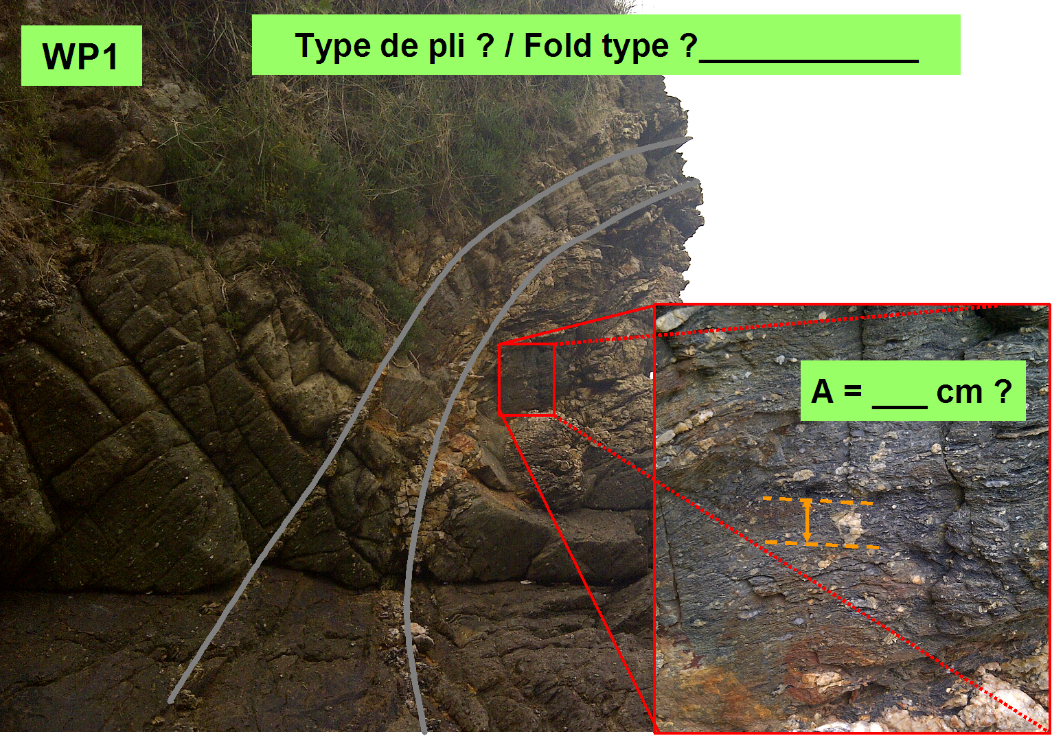
Au premier Way Point, prenez un peu de recul et observez la pointe de la falaise. Nous nous trouvons dans une formation géologique métamorphique. L’axe de ce pli est orienté environ Nord-Sud.
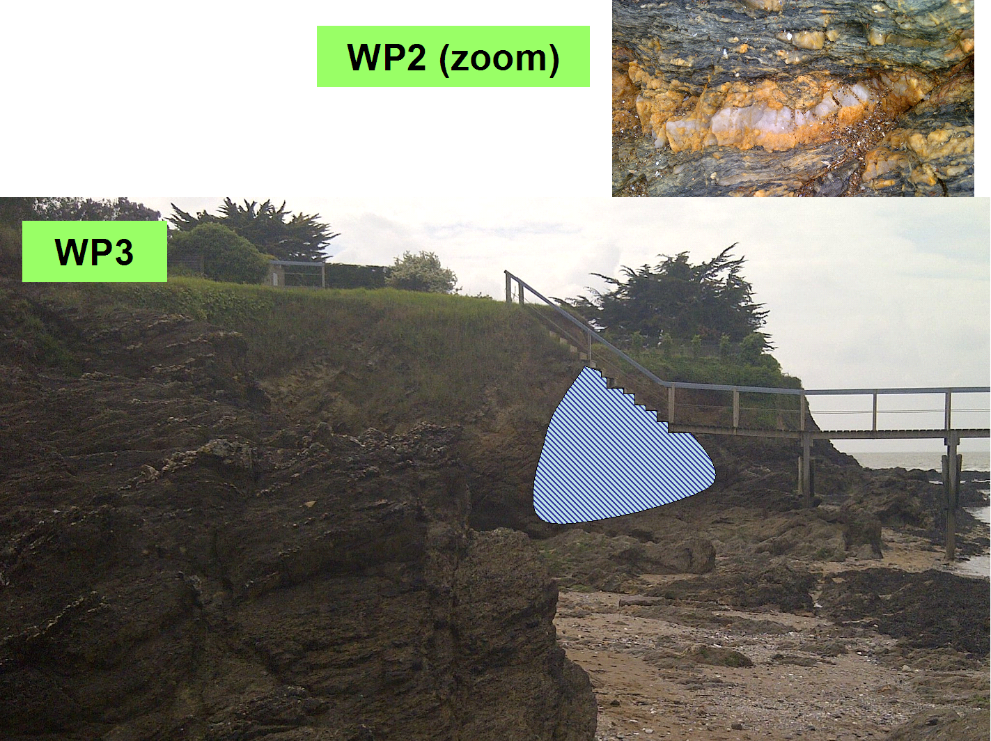
Au second Way Point, vous êtes sur un filon couche constitué de quartz (blanc-gris) et de Feldspath (jaune-orangé). Celui-ci est orienté environ ESE-WNW, avec un pendage d’environ 45° vers le Sud.
Depuis le troisième Way Point, il vous faudra observer les roches sous l’escalier qui mène à la pêcherie.
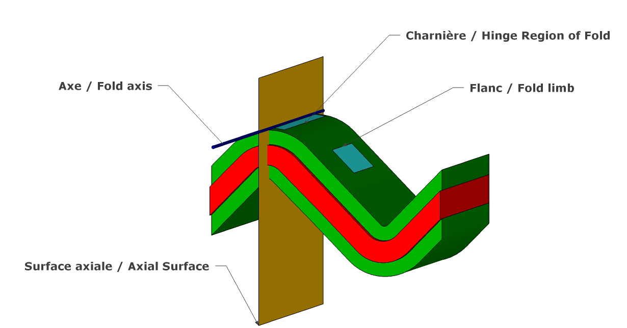
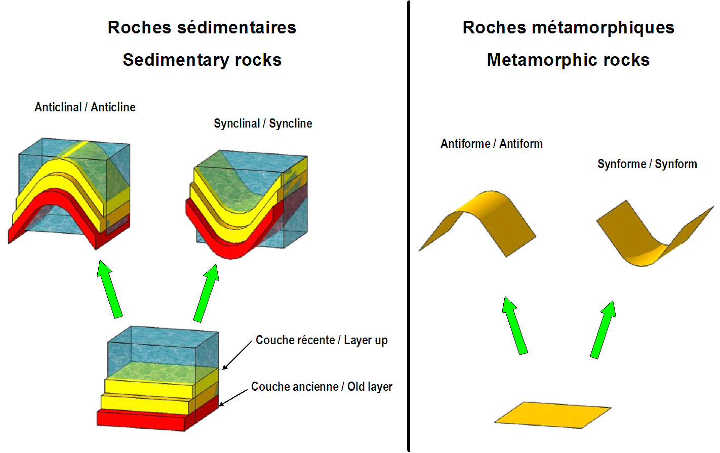
Voici quelques types de plis, vus en trois dimensions, sur les figures suivantes.

 Here are some types of folds , seen in three dimensions , the following figures .
There are of course an infinite number of folds in nature. So that we can understand , geologists determined on a few main types , so you do not have to systematically describe in detail. To determine , geologists had different types of approaches : some are very mathematical , others purely naturalistic . The fold is drawn after calculating geometric formulas , or more simply using a pencil on a sheet of paper , the key is that we recognize the fold represented with that which is observed ...
Please have a tape measure . Attention, it is essential to make this earthcache at low tide.
The first way point , take a step back and observe the tip of the cliff. We are in a metamorphic geological formation. The axis of this fold is oriented approximately north-south .
The second way point , you're on a sill of quartz (white - gray) and feldspar (yellow- orange). It is oriented approximately ESE -WNW , with a dip of about 45 ° to the south.
Since the third way point , you will see the rocks under the stairs leading to the fishery.
Pour loguer cette cache / To log this cache :


 Pour valider votre visite sur le site, envoyez-moi, en précisant bien le nom de l’earthcache, vos réponses par courrier électronique aux questions suivantes. Vous pouvez loguer "Found it", et je vous contacterai en cas de nécessité:
Question 1: WP1 : Quelle est la structure que vous voyez ? Un anticlinal, une antiforme, un synclinal, ou une synforme ?
Question 2 : WP1 : sur le zoom, quelle est la mesure A en cm
Question 3 : WP2 : quels sont les deux minéraux visibles sur la photo ?
Question 4: WP3 : que distinguez-vous au niveau de la zone hachurée bleutée ?
Une photo du site sera la bienvenue, bien que facultative.
 To validate your visit to the site , email me, stating clearly the name of the earthcache your answers by email to the following questions . You can log in " Found it ," and I will contact you if necessary :
Question 1: WP1 : What is the structure you see ? An anticline , an antiform , a syncline , or synformal ?
Question 2: WP1 : look at the zoom, what is the measure A, in cm ?
Question 3: WP2 : what are the two minerals visible on the photo ?
Question 4: WP3 : that distinguish you in the blue shaded area ?
A photo site will be welcome , although optional.
Sources / Sources :
Documentation « papier » : Notice de la carte géologique de la France au 50000ème, feuille «Paimboeuf», XI-23, n°480, Dictionnaire de géologie Masson, Série des Guides géologiques Masson, Méthodes modernes de géologie de terrain – 2a manuel d’analyse structurale Editions Technip, The Mapping of Geological Structures - Ken McClay – Geological Society of London – Handbook Series, Principes de Tectonique – A.Nicolas – Masson, Initiation à la géologie – Mémento du géologue – Ch.Pomerol et A.Blondeau – Ed.Boubée.
Consultations sur Internet: http://infoterre.brgm.fr/ ; Google Earth ; Geowiki ; Wikipedia ; http://geophysics.ou.edu/geol1114,
 Rappel concernant les « Earthcaches »: Il n'y a pas de conteneur à rechercher ni de logbook à renseigner. Il suffit de se rendre sur les lieux, de répondre aux questions ci-dessus et de nous renvoyer les réponses.
 Reminder on "Earthcaches" There is no container or logbook to find information. Simply visit the site, to answer questions above and send us the answers.
Vous aimez les earthcaches, mais alors, si ce n'est pas déjà fait, qu'attendez-vous pour vous inscrire ? C'est ici: http://coord.info/GC5HKV6
ou consulter le site dédié, c'est là:
