The Great Gallery EarthCache
-
Difficulty:
-

-
Terrain:
-

Size:  (other)
Please note Use of geocaching.com services is subject to the terms and conditions
in our disclaimer.
Horseshoe Canyon is a separate unit of the Canyonlands National Park that contains some of the most remarkable pictographs in North America as well as tracks of dinosaurs that once inhabited the area. This earthcache looks at how earth science has contributed to our understanding of this site. The listed coordinates take you to the trailhead for a hike into the canyon. Please read this description and plan your trip carefully before visiting.
There are four primary pictograph sites that you will see in this canyon, but the Great Gallery of Horseshoe Canyon is the ultimate destination. It contains astonishing Barrier Canyon Style images, including the “Great Ghost” (often called the “Holy Ghost and Its Attendants").
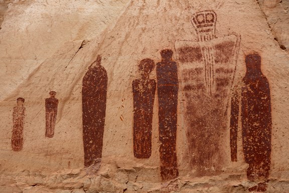
Pictographs are painted on the surface of the rock (as opposed to petroglyphs that are carved into rock). The unique rock art style here was created by a combination of wall preparation, rock pecking, and application of multiple pigments.
Dating it has been difficult. Estimates have ranged from relatively recent times (1000 years or less) to being among the earliest pictographs on the Colarado Plateau, about 9,000 years old. Studies have focused on methods ranging from stylistic comparison to radiocarbon dating, but none have given an answer that is widely accepted. The geological record allows us to bracket the window of time when it was physically possible to create the art.
GEOLOGICAL DATING
Horseshoe Canyon contains a series of preserved alluvial terraces that record the burial and exposure of the alcove that now hosts the Great Gallery. Around 14,000 years ago there was a long cliff face buried beneath sediment. As the sediment eroded in the canyon, the Navajo Formation bedrock walls were exposed (6000 years ago). Over time, cracks appeared in certain areas due to water seepage and temperature changes. Sandstone slabs broke off from the cliff face to form alcoves.
People eventually came down into the canyon as hunters and gatherers. The artists who created the pictographs found smooth protected surfaces that were ideal canvases.
Dr. Joel Pederson, a geologist from Utah State University, used Optically Stimulated Luminescence (OSL) to date this site by determining when sunlight stopped shining on the surface of the rocks - in other words, when the rock fell. By measuring the age of rockfalls that occurred before and after the pictographs where created, it is possible to narrow the range of time and bracket when it was physically possible to have done the work.
As mineral grains, such as quartz or feldspar, are exposed to sunlight they lose their natural luminescence. After being buried in a rockfall, they are removed from light and exposed to natural radiation from the surrounding environment. Through time, these minerals regain luminescence. The crystal grains are collected in total darkness and brought into the laboratory so that they can be stimulated with an energy source, such as a laser. They emit the collected energy as light, which can be measured to determine the length of time the mineral was buried.
Dr. Pederson's group first examined rocks that had fallen off the cliff after the pictographs were painted. While turning over the rock, they found cottonwood leaves plastered on the underside. OSL dated the rockfall as being about 820 years old. A comparison study of the sandy sediment placed the date at 890 years. Radiocarbon techniques dated the leaves as being 930 years old.
These dates fell within the same margins of error. Dr. Pederson notes that this was the first time a date of a rockfall could be determined so accurately. It appears that the pictographs would have been painted before A.D. 1100.
It was also important to look at the date the alcove was formed. Since the pictographs had to be painted after the rocks broke off to form the alcove, the rockfall from this event could supply the outer range for the art. A 2010 student thesis (linked below) suggested that dates from 2000-4000 years ago could not be ruled out. In 2012, Dr. Pederson reported that he found that the alcove likely dated from around A.D. 400, which would make the pictographs younger than many estimates.
There is work to be done in the canyon and OSL dating is a relatively new technique. Still, earth science has provided significant guidance to narrow the range of dates for the pictographs. It remains for others to determine what this means in terms of our understanding of the art and the culture that produced it.
THE EARTHCACHE JOURNEY
The earthcache starts at the trailhead to Horseshoe Canyon. It is a long drive over dirt roads. A carefully driven passenger car in good weather can reach this area. Before setting out, however, you should contact Canyonlands National Park for information on road conditions.
The Lower San Rafael Road goes directly from Green River and shouod normally be in good condition, but we have taken the route recommended on other sites - Highway 24 south from I-70 for 25 miles. Turn on the road near mile marker 135.5 that is signed for Rooster Flats and Hans Flat Ranger Station (about 1/2 mile south of the turn off to Goblin Valley State Park. Stay on this road for 29 miles, keeping left as you pass an information kiosk) until you reach a smaller road to the right that is signed for the Horseshoe Canyon trail. This road is rougher than the previous road, but we drove it with a small sedan car. Again, conditions can vary so obtain as much information as you can before setting out.
The hike to the Great Gallery is about a 7 mile round trip. The first 1 1/4 mile descends 780 feet over a slickrock trail marked by rock cairns. The trail was once used by vehicles for oil exploration.
About 1/2 mile from the trailhead, you will find 12-inch dinosaur tracks that were probably made by an allosaurus. When we visited, the tracks were marked by small rocks. Pay close attention to the depth of the tracks, its shape, and the direction that dinosaur was walking.
When you reach the canyon floor, the trail follows the sandy stream bed. It had rained a week before our hike so the sand was firm for most of the way, but during the summer months it can be far more tiring, like walking across beach sand. Be prepared.
Follow the cairns to the the first set of pictographs, the High Gallery on the east canyon wall. Look at the surrounding cliff and how the gallery is protected from weathering. Think of how the geology of the area contributed to this spot.
The second site is very nearby. On the west side of the canyon you will find the Horseshoe Gallery. Again note at how the geology of the area led it to be chosen as a site for rock art. What qualities of the rock here enabled it to be used for pictographs?
Around 1/2 mile upstream from there, you will come to the Alcove Gallery (west canyon walls). Estimate the size of the alcove and the amount of debris found there. Do you think the debris could be used to date this site?
As you walk towards the Great Gallery there will be a flat slickrock area slightly above the stream bed to your immediate left (east of the stream) as the channel bends through a narrower part of the canyon. The trail itself has been rerouted around the rock due to erosion and the changing stream pattern. Go to the flat rock and look for another dinosaur track. When we visited, the track was marked by small rocks.
This track is elevated, so that the softer rock eroded around the track leaving the imprint exposed. Does it appear to be made by the same dinosaur that created the first track? Is it headed the same direction as the first track that you found?
The Great Gallery is also on the west side. It is unmistakable and the park maintains a register there for people to sign. When we visited, a park volunteer helped us to identify various aspects of the rock art. Look at the alcove where the gallery is located. What do you see that might have helped geologists identify different rockfalls in order to date this site?
LOGGING REQUIREMENTS
Answer the following questions based on what you have observed on the journey. Send your answers through my geocaching profile before logging this earthcache as a “find.” I regret having to say that logs without answers will be deleted.
Please email me through my profile rather than use the message center.
1. The Trailhead:
What is the age of the panels that is estimated on the kiosk? After reading the information on this page and visiting the sites in the canyon, do you agree? Why or why not?
2. The Galleries:
A. Estimate the percentage of the Alcove Gallery that is covered in debris. Do you think that all of the debris fell before or after the pictographs were created? Could this be used to help date the site?
B. Describe how the rockfall at the Great Gallery allowed geologists to date the Gallery's earliest and latest dates. In other words, what specifically do you see at the site that would allow you to determine that debris fell after the pictographs were painted? How would you determine what debris fell when the alcove was formed?
C. Include a picture of the Great Gallery that includes you, your gpsr, or a personal item. Please note that changes to the guidelines (June 2019) no longer mandate that photos are an optional logging requirement.
3. Optional Bonus Questions:
Do you think the dinosaur tracks were made by the same species? Why do you think the type of tracks differ?
OTHER IMPORTANT INFORMATION
You will be walking about 800 feet in elevation down to the canyon floor, climbing out on your return. Be aware of weather conditions. The area can be subject to flash floods, high winds, or hot weather.
As with any other desert environment, you need to be prepared for the hike. The canyon can be very hot, bring at least a gallon of water and suitable clothing if hiking under these conditions. The climb out of the canyon has been described as “brutal” during the summer months. The hike along the creek bed can be very sandy. The terrain level would vary accordingly.
There is no camping on the canyon floor, although you can camp at the trailhead. Walk lightly. Take out what you brought in.
Respect the roped barriers at each of the sites and do not cross them to take a better look. Under no conditions should you touch any of the art. Bring binoculars for the best viewing.
Additional waypoints are provided for the major points of interest describe above. The Climb Utah site also lists coordinates that may be slightly different. Please keep in mind that you will be in a canyon, therefore the additional waypoints are provided as approximate guides. Follow the rock cairns to the major pictograph sites and pay attention to the description here to find the dinosaur tracks in the canyon.
There are ranger-led hikes to the sites on weekends in the Spring and Fall. Check the National Park Service site listed below for current information on these hikes.
LINKS
The Area:
National Park Service: Essential information on Horsehoe Canyon.
Climb Utah: An excellent trail guide, including coordinates for the road and trail. Some of these coordinates differ slightly from the readings I took, but got me to where I needed to go.
The Geology:
Utah Rock Art: The lead article presents an overview of the OSL dating and the Pederson Study that measured the Great Gallery.
Bracketing the Age of the Great Gallery: Honors Thesis by Melissa Jackson, Utah State University, providing an excellent description of the site and OSL dating.
Constraining the Age of Rock Art: Research paper (Chapot, Sohbati, Murray, Pederson, Rittenour) describing how OSL and radiocarbon dating established a minimum age for the Great Gallery.
Optically Stimulated Luminescence (OSL) as a Chronometer: Abstract of 2012 paper (Sohbati, Murray, Chapot, Jain, Pederson, Journal of Geophysical Research) using OSL for surface exposure dating at the Great Gallery, setting maximum dates described above.
Additional Hints
(No hints available.)