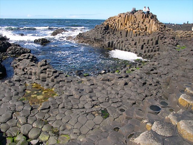
A Calçada dos Gigantes (em inglês Giant's Causeway) é a designação dada a um conjunto de cerca de 40 000 colunas prismáticas, encaixadas como se formassem uma enorme calçada de pedras gigantescas, formadas pela disjunção prismática de uma grande massa de lava basáltica resultante de uma erupção vulcânica ocorrida há cerca de 60 milhões de anos. A atividade vulcânica nessa área fez a rocha derretida subir através de fendas no calcário, com temperatura média de mais de 1000 °C. Quando entrou em contato com o ar, resfriou e solidificou. A rocha derretida, ou magma, é composta por muitos elementos químicos e por isso pode criar vários tipos de rocha. O magma encolhia-se à medida que se resfriava lentamente e, por causa de sua composição química, fendas hexagonais regulares formaram-se na superfície. Enquanto o magma continuava a resfriar por dentro, as fendas desciam gradualmente, formando a grande quantidade de colunas semelhantes a lápis. (Wikipedia)
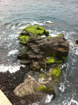
Algo de semelhante parece ter ocorrido na Ilha da Madeira.
As origens vulcânicas da Madeira permanecem bem visíveis em locais como o anfiteatro montanhoso que envolve o Funchal, vestígio de uma antiga caldeira. A ilha é extremamente acidentada, com picos que atingem os 1860 m de altitude. Felizmente para os turistas, a actividade vulcânica cessou há cerca de 6500 anos – contudo, foi essa actividade que dotou a ilha de uma paisagem fértil, formada até recentemente por um importante manto de antigas florestas subtropicais que esteve na origem do seu nome – Madeira.
Para além das magnificas florestas, podemos também observar por toda a Ilha vestigios da atividade vulcânica que a formou. O arquipélago da Madeira, que compreende as ilhas da Madeira, de Porto Santo, Selvagens e Desertas, é de origem vulcânica e localiza-se no oceano Atlântico. A maioria das ilhas atlânticas e o Arquipélago da Madeira em particular, está intimamente ligado à abertura do Atlântico, processo que se iniciou há cerca de 200 M.a., no Triásico, e continua actualmente.
No GZ parece ter ocorrido uma escoada de lava que formou uma dijunção prismática em basalto.
Visitem o local e tirem as vossas próprias conclusões.
Para efetuarem o log desta Earthcache terão de responder a quatro questões:
1- Em que país fica situada a verdadeira Giant’s Causeway?
2- Que tipo de rocha compõe esta formação rochosa?
3- Em que ano foi a Giant’s Causeway declarada Património da Humanidade?
4- No gz, virado para o mar e tendo Causeway madeirense à sua frente, que forma geométrica destingue numa das rochas: quadrado, pentágono ou hexágono?
Tarefa adicional e opcional: Nas coordenadas dadas, o geocacher deve tirar uma foto sua com o “Giant’s Causeway madeirense" como pano de fundo.
Só serão aceites logs depois das respostas enviadas serem validadas pelo owner.
The Giant's Causeway (known as Clochán an Aifir or Clochán na bhFomhórach in Irish[1] and tha Giant's Causey in Ulster-Scots)[2] is an area of about 40,000 interlocking columns, the result of an ancient volcanic eruption. In a 2005 poll of Radio Times readers, the Giant's Causeway was named as the fourth greatest natural wonder in the United Kingdom.[3] The tops of the columns form stepping stones that lead from the cliff foot and disappear under the sea. Most of the columns are hexagonal, although there are also some with four, five, seven or eight sides. The tallest are about 12 metres (39 ft) high, and the solidified lava in the cliffs is 28 metres (92 ft) thick in places. The Giant's Causeway is today owned and managed by the National Trust and it is the most popular tourist attraction in Northern Ireland.[4]
Something similar seems to have occurred on the island of Madeira.
The volcanic origins of Madeira remain clearly visible in places like mountainous amphitheater surrounding Funchal, vestige of an old boiler. The island is extremely rugged, with peaks that reach 1860 m altitude. Fortunately for tourists, volcanic activity has ceased for about 6500 years - however, was that activity that has given the island a fertile landscape, until recently formed by a large mantle of ancient subtropical forests which is at the origin of its name - Madeira.
In addition to the magnificent forests, we can observe throughout the Island traces of the volcanic activity that formed it. The archipelago of Madeira, comprising the islands of Madeira, Porto Santo, Desertas and Selvagens, is of volcanic origin and is located in the Atlantic Ocean. Most Atlantic islands and Madeira Islands in particular, is closely linked to the opening of the Atlantic ocean, a process that began about 200 Ma in the Triassic, and continues today.
At the GZ seems to have occured a lava flow that formed a prismatic basalt disjunction.
Visit the site and draw your own conclusions.
To log this EarthCache you must answer four questions:
1 - In what country is situated the real Giant's Causeway?
2 - What kind of rock makes up this rock formation?
3 - In what year was the Giant's Causeway World Heritage Site declared?
4 - At the gz, facing the sea and having madeiran Causeway in front of you, what shape can you distinguish in one of the rocks: a square, a pentagon or a hexagon?
Optional and additional task: In the given coordinates, the geocacher must take a picture with the “Madeiran Giant's Causeway” as background.
Logs will only be accepted after the validation of the answers by owner.