Das Schongauer-Bähnle auf dem Grund des Meeres?
Bei den hier sichtbaren Aufschlüssen entlang des Bahndamms im Hühnerbachtal handelt es sich zum Teil um sehr sehr alte Gesteinsschichten, welche früher noch auf dem Grund eines Ur-Meeres lagen. Das Hühnerbachtal jedoch war eisfrei und ragte wie eine kleine Zunge bis südlich von Bidingen in den Gletscher hinein. Über das Hühnerbachtal entwässerte der Wertach-Lech-Voralpengletscher in die Wertach, von dort in den Lech, der das Schmelzwasser weiter in die Donau brachte.
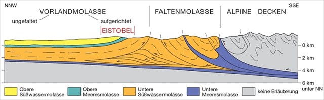
Die Entstehung der Faltenmolasse:
Als Subalpine Molasse wird in der Geologie ein schmaler Bereich von Molassesedimenten am Alpennordrand bezeichnet. Eine andere Bezeichnungen der Subalpinen Molasse ist die Faltenmolasse.
Nördlich der Subalpinen Molasse befinden sich die Gesteine der Vorlandmolasse in überwiegend ungestörter Lagerung.
Im Süden wird die subalpine Molasse von den Ketten des Helvetikums, der Flyschzone und teilweise den Nördlichen Kalkalpen begrenzt.
Die subalpine Molasse zeigt zunächst die gleiche Entstehungsgeschichte wie die Molassesedimente im bayerischen Alpenvorland (Allgäu, Chiemgau, Berchtesgadener Land). In der zweiten Hälfte der Alpenfaltung, das heißt in einer Periode die etwa vor 20 Millionen Jahren begann und rund 15 Millionen Jahre dauerte, wurden dann die helvetischen Decken über die alpenrandnahe Molasse geschoben. Das Ausmaß der Überschiebung beträgt im Mittel in der Schweiz etwa 15 bis 25 km, kann aber regional auch wesentlich größer sein. Gleichzeitig waren die tektonischen Bewegungen noch nicht zum Stillstand gekommen: die alpinen Decken rückten weiter nach Norden vor, wodurch Ablagerungen am Südrand des Molassebeckens als Faltenmolasse in den Deckenbau der Alpen mit einbezogen wurden.
Das besondere an dieser Geologie vor Ort ist, dass man die Möglichkeit hat, die ein oder andere Versteinerung in der Faltenmolasse zu finden. Also vielleicht findet ihr ja so etwas. Wenn ja, würde ich mich sehr über ein Foto des Fundes freuen. Na dann, viel Spaß bei der geologischen Satzsuche.
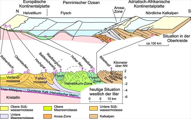
Foto: Die Entstehung der Alpen durch die Verschiebung der Erdplatten.
Quellen:
-Infotafel vor Ort (gefördert durch das bayerische Staatsministerium für Ernährung, Landwirtschaft und Forsten
-LFU Bayern
-wikipedia
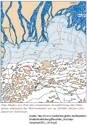
Im oberen Bild ist es sehr gut zu sehen, wie weit der Gletscher ins Voralpenland gereicht hat.
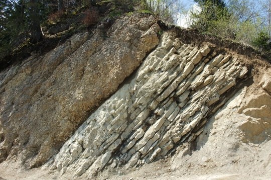
Auf diesem Foto ist sehr gut zu sehen, wie die Faltenmolasse in der Natur aussieht.
Um mehr über das Thema zu erfahren, müsst Ihr vor Ort und müsst gleichzeitig vier Aufgaben erfüllen:
1. Welche zwei Platten formten die Alpen?
2. Was genau kann man mit viel Glück in der Faltenmolasse finden?
3. Seit wievielen Jahren sind diese Gesteinsschichten sichtbar?
4. Macht ein Foto von euch vor Ort (freiwillig)
5. Ihr dürft gleich loggen. Schickt mir die Antworten, falls etwas falsch ist, melde ich mich. Danke.
Englisch:
The Schongauer Bähnle on the bottom of the sea ?
The visible here outcrops along the railway embankment in Hühnerbachtal is partly to very ancient layers of rock, which earlier were still lying on the bottom of a primordial sea. However, the Hühnerbachtal was free of ice and stood like a little tongue to south of Bidingen in the glacier into it. About the Hühnerbachtal the Wertach Matte Alps glacier drained into the Wertach, from there into the Lech , who brought the melt water further into the Danube.
The emergence of Faltenmolasse :
As Subalpine Molasse a narrow range of Molassesedimenten is called on the northern edge of the Alps in geology . Another names of the Subalpine Molasse is the Faltenmolasse . North of the Subalpine Molasse are the rocks of the Vorlandmolasse in predominantly undisturbed storage. In the south the subalpine Molasse is bounded by the chains of the Helvetic , the flysch zone and partly the Northern Limestone Alps . The subalpine Molasse initially shows the same genesis as the Molassesedimente in the Alpine foothills of Bavaria (Allgäu , Chiemgau, Berchtesgaden ) . In the second half of the Alpine folding , ie in a period which began about 20 million years ago and 15 million years of rebuilding , the Helvetic ceilings were pushed over the alps close to the edge molasses . The magnitude of the thrust is on average in Switzerland about 15 to 25 km, but can be regional also much larger. At the same time the tectonic movements were not yet come to a standstill : the Alpine nappes moved further northward , of which deposits were included on the southern edge of the Molasse Basin as Faltenmolasse in the ceiling construction of the Alps .
What is special about this geology on site, that one has the opportunity to find the one or other petrification during the Faltenmolasse. . So skills you find something. If so, I would love to see a photo of the find. Well then, have fun with the geological record search.
Sources:
Info panel on site (funded by the Bavarian State Ministry for Food , Agriculture and Forestry
- LFU-Bavaria
- wikipedia
To learn more about the subject, you have to spot and have to simultaneously perform four tasks :
1 What two plates formed the Alps?
2 What exactly can you find with a lot of luck in the Faltenmolasse?
3 Since how many years these rock layers are visible?
4 Take a picture of you on the spot ( optional)
5 You can log right away. Send me the answers, if anything is wrong I'll get back to you.