Do dziś rozpowszechnione jest błędne przekonanie, że Półwysep Helski powstał w wyniku połączenia istniejącego wcześniej łańcucha wysp. Tak naprawdę Mierzeja Helska zaczęła się kształtować ok. 5,5 tysiąca lat temu, kiedy to ustabilizował się poziom morza, a obfitość piasku pozwoliła na uformowanie się zaczątków mierzei na przedłużeniu północnych brzegów Kępy Swarzewskiej, które cofały się w stronę lądu, niszczone przez morze. Wraz z nimi przesuwała się cała mierzeja, przyjmując stopniowo równoleżnikowy kierunek osi. Segmenty narastania półwyspu wyznaczane są przez dawne wały brzegowe, zachowane na odcinku pomiędzy Juratą a Helem.
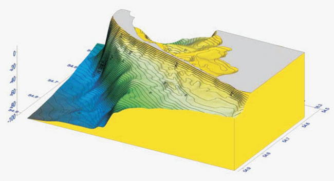
Ukształtowanie dna w rejonie Półwyspu Helskiego,
L. Łęczyński, Morfolitodynamika przybrzeża Półwyspu Helskiego, WUG
Najbardziej charakterystyczną cechą przekroju geologicznego mierzei jest odmienna budowa jej części północno-zachodniej i południowo-wschodniej. W tej pierwszej występują utwory kredy, przykryte serią paleogenu i neogenu, na których znajduje się cienka warstwa gliny polodowcowej i piaski czwartorzędowe. Z kolei wschodnia część charakteryzuje się głębokimi rozcięciami kopalnymi w powierzchni kredowej, wypełnionymi materiałem polodowcowym, takim jak gliny, piaski i mułki. Niektóre z tych form były szlakami odpływu wód lodowcowych. Poza tym powszechnie występuje tu cienka warstwa tzw. iłów czekoladowych, które nagromadziły się po ustąpieniu lądolodu skandynawskiego.
(Na podstawie materiałów opracowanych przez Annę Tomczak et al.,
Państwowy Instytut Geologiczny, Gdańsk 2009).
Zadania:
- Mierzeja Helska jest formą geologicznie stabilną, jednak od kilku dziesięcioleci jej brzegi są zagrożone i wymagają ochrony. Jak sądzisz, co powoduje niszczenie linii brzegowej? Wymień dwa główne czynniki.
- Co można powiedzieć na temat szaty roślinnej w miejscu, w którym stoisz?
- Jak scharakteryzowałbyś własności piasku w tym miejscu? Jak sądzisz, dlaczego piasek jest tutaj właśnie taki?
- Jaki stworzony przez człowieka obiekt znajduje się w pobliżu miejsca wskazanego przez współrzędne?
- Zadanie opcjonalne: wklej do logu zdjęcie wykonane na cyplu (proszę nie zamieszczać fotospoilerów).
Odpowiedzi proszę przysyłać poprzez formularz kontaktowy w moim profilu. Nie trzeba czekać na moją odpowiedź, można od razu logować znalezienie. Dam znać, jeśli nadesłane odpowiedzi będą niepoprawne. Logi osób, które nie przysłały odpowiedzi, będą kasowane.
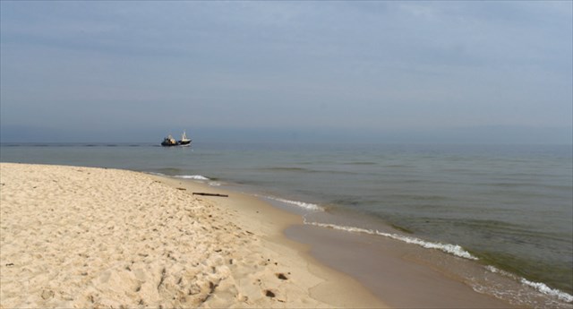
Photo courtesy of hanbei

There is a widespread misconception that the Hel Peninsula has formed from a chain of islands. In fact it started to take shape about 5500 years ago, after sea level stabilized. Huge amounts of sand started to accumulate at the northern shores of Kępa Swarzewska, which were receding at that time. The entire peninsula moved towards the land as well, gradually obtaining a latitudinal orientation. Successive segments of the peninsula are marked by coastal berms located between Jurata and Hel.
Shape of the seabed near the Hel Peninsula,
L. Łęczyński, Morfolitodynamika przybrzeża Półwyspu Helskiego, WUG
One of the most characteristic traits of the geologic cross-section of the peninsula is the huge difference in structure between its NW and SE parts. The former is composed of structures dating back to the Cretaceous period, covered by Paleogene and Neogene remnants, on top of which there is a thin layer of postglacial clay and Quarternary sand deposits. In the eastern part, on the other hand, there are deep cuts within the Cretaceous surface, filled with postglacial deposits (clay, sand and silt). Some of these forms served as drainage for glacial meltwater. The so-called chocolate loam, accumulated after the withdrawal of the Scandinavian glacier, is also widespread in the area.
(Based on a brochure by Anna Tomczak et al.,
Polish Geological Institute, Gdańsk 2009).
Tasks:
- What causes the coastal erosion of the peninsula? Name two main factors.
- What can you say about the vegetation here?
- Describe the properties of sand here. Why do you think it is so?
- What kind of a man-made object is located near the place indicated by coordinates?
- Optional task: take a picture at the location and upload it to your log (no photo spoilers, please).
Answers can be sent via the contact form in my profile. There’s no need to wait for my reply, feel free to log right away. I’ll let you know in case your answers are incorrect. Logs that do not meet the logging requirements as well as spoiler logs will be deleted.

German version by JanboGC - danke schön!
Laut eines weitverbreiteten Irrglaubens entstand die Halbinsel Hel aus einer Reihe kleiner Inseln. Tatsächlich aber formte sie sich vor 5500 Jahren, als sich der Meeresspiegel stabilisierte. Riesige Mengen Sand begannen sich an den nördlichen Ufern des Kępa Swarczewka anzuhäufen, welche damals zurückgingen. Doch auch die gesamte Halbinsel bewegte sich in Richtung des Festlandes, wobei sie nach und nach eine breite Ausrichtung bekam. Aufeinanderfolgende Teile der Halbinsel zwischen Jurata und Hel sind gezeichnet von Küstenabstufungen, die auch Bermen genannt werden.
Form des Meeresbodens an der Halbinsel Hel.
L. Łęczyński, Morfolitodynamika przybrzeża Półwyspu Helskiego, WUG
Charakteristisch für den geologischen Querschnitt der Halbinsel Hel ist der große strukturelle Unterschied zwischen der Süd-Ost und der Nord-West Seite. Letztere ist zusammengesetzt aus Strukturen der Kreidezeit, bedeckt von Überresten des Paläogens und des Neogens, worauf sich eine dünne Schicht nacheiszeitlicher Lehm und Sand aus dem Quatär abgelagert haben. Im östlichen Teil hingegen sind tiefe Einschnitte in der kreidezeitlichen Schicht, welche mit nacheiszeitlichen Rückständen (Lehm, Sand und Schlick) gefüllt sind. Manche dieser Strukturen dienten als Abfluss für das Schmelzwasser der Gletscher. Der sogenannte Schokoladen Lehm häufte sich nach dem Zurückweichen des Skandinavischen Gletschers an und ist ebenfalls häufig in dieser Gegend.
(Basierend auf einer Broschüre von Anna Tomczak u.a.,
Polnisches Geologisches Institut, Gdańsk 2009)
Aufgaben:
- Was verursacht die Erosion der Küste der Halbinsel? Nenne zwei Hauptgründe.
- Was kannst du über die Vegetation hier sagen?
- Beschreibe die Eigenschaften des Sandes. Was glaubst du, warum er so ist?
- Welches, von Menschen erbaute, Objekt ist in der Nähe der Koordination?
- Optional: Mach ein Bild der Region und sende es mit dem Log (bitte keine Bilder, die Antworten auf die Fragen geben).
Die Lösungen können mit der Kontaktieren-Funktion auf meinem Profil abgegeben werden. Ihr müsst nicht auf eine Antwort warten, loggt einfach direkt danach. Ich melde mich, sollten die Lösungen falsch sein. Logs ohne (korrekte) Erfüllung der Aufgaben oder mit Vorwegnahme der Lösungen, werden gelöscht.
With this EarthCache I reached the Silver level in the EarthCache Masters series: