 The Zêzere River is a river entirely Portuguese. Born in Serra da Estrela (Estrela Mountains), at about 1900 m altitude, near the "Cântaro Magro". Still in the Serra da Estrela area, it flows through "Manteigas" and near the city of Covilhã, thence southwesterly, converging with the Tagus River west of Constança, after a course of about 200 km.The river Zêzere is the second largest river exclusively Portuguese, after the Mondego river. Its river basin is 5043 km² (1056 km² of which belong to the Nabão river. On-site observation, the Miradouro da Sarnadela in Janeiro de Cima, are about 80km from the source.
Downstream dominate the trench meanders, reaching 300 m deep. These extend for 53 km, to the granite Pedrógão, with over 46 km, bordering the municipality of Oleiros. The trench meanders have symmetrical margins, or almost, and derive from free meanders that later fell into place in a single step of river incision. The ins and outs, as well as its sharp sinuosity by fractures in the substrate, are the product of tectonic subsidence in the N bordered by "Cebola" fault developed between the secondary horsts of "Cabeço Rainha" and the main horst of the "Serra da Estrela".
"the meanders are not whims of nature, but rather the way the river carries out his work by the law of least effort." Christofoletti Antonio (1980, p.89)
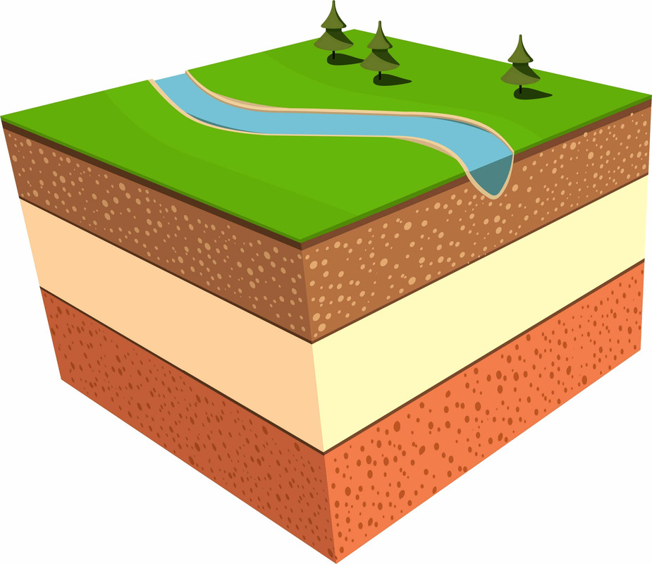
The sharp bend of a river that flows in a floodplain is called a "meander". The term derives from the Meander River in Turkey, characterized by a very winding course, and has been used since the sixteenth century.
The meanders change shape and position as the variations of energy and river load occur. They originate and evolve due to the dynamic force of the river flow, the Coriolis force, and geomorphological processes.
Meanderss are typical of floodplains, where the surface is quite flat (mature topography), although possible, too, albeit in a more limited way, in other situations. The trend for lowland rivers to meander is a form of energy dissipation during periods when flows are higher.
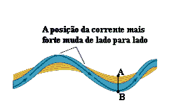
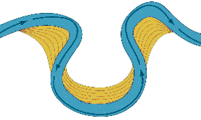
As the speed of the river flow is greater on the outside than on the inside of meander, they present clear and consistent tendency to be eroded in the outer margin, and to deposit sediment on the opposite bank, which leads to the pronouncement of the meander. For this reason, the river course has a permanent tendency to move towards the concave bank of the meander.
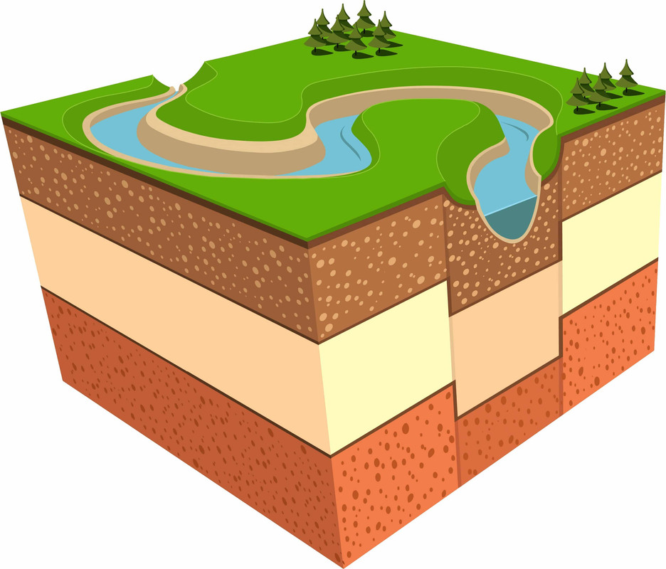
Sometimes the meandering reaches virtually 360 °, leaving the stream flow of the use, the flow passing by the most direct and easy route. The meander ends, consequently, to stay idle:. Originates, therefore, one corresponding to an abandoned lake meander shaped like a U - called an Oxbow lake

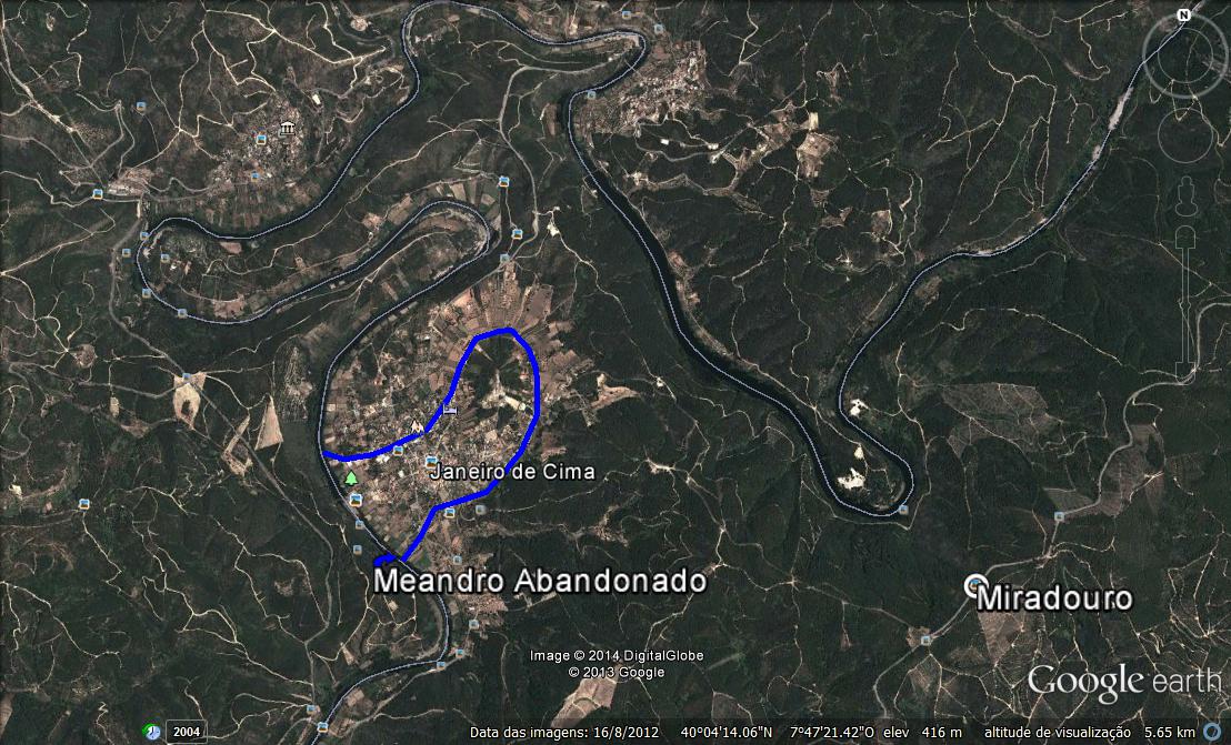
At the point of observation is not possible to visualize this type of phenomenon, but by the expected progress of the river erosion it is likely to be an abandoned meander in the future. In the image below you can see the location of the abandoned meander of Janeiro de Cima, already formed:

According CHRISTOFOLETTI A. (1981, p. 292) "The embedded meander appear when the scale of the meandering channel is similar to its valley. The meanders due to uplift (tectonic), or the lowering of the base level (eustasia) will 48entalhando underlying layers. In view Davisiana docked intricacies are signs of rejuvenation of landscapes."
According THORNBURY (1969) identical to the intricacies Zêzere can be like "where the river carves vertically thereby resulting in almost identical slopes for both sides, and those who have suffered displacement, resulting in steeper slopes in the hollows of the valley and meandrine more gentle slopes in the convexities. In this situation it is likely that the increased tortuosity occurred during the carving"
To log this Earth Cache will have to answer the following questions and send me the answers.
1. In your own words explain what are the main factors of formation and evolution of meanders .
2. The speed of the river flow is greater in the inside or outside of the meander?
3.What can happen to meander you are watching?
4. Assuming that the wider section of the meander is about 300m, estimates the width of the narrow end (Tip : use the technique as explained here)
5. Using the value obtained in question 4 , and assuming that the the erosion progresses 0.2 cm per year at every turn, estimates the time it takes to become a meander abandoned meander.
6. There is a guard at the viewpoint of wood. In the center of the semi circumference, this guard is attached to the center pile by how many nails?
7. With your log publish a photo with your GPS in front of the Meander on the lookout. (optional)
 O Rio Zêzere é um rio inteiramente português. Nasce na serra da Estrela, a cerca de 1900 m de altitude, junto ao Cântaro Magro. Ainda na zona da serra da Estrela, passa por Manteigas e próximo da cidade da Covilhã, seguindo depois para sudoeste, confluindo com o rio Tejo a oeste de Constância, após um curso de cerca de 200 km.
O rio Zêzere é o segundo maior rio exclusivamente português, após o rio Mondego. A sua bacia hidrográfica tem 5043 km² (dos quais 1056 km² pertencem ao rio Nabão. No local de observação, o miradouro da Sarnadela em Janeiro de Cima, encontram-se a cerca de 80km da nascente.
Para jusante dominam os meandros de trincheira, atingindo 300 m de profundidade. Estes estendem-se por 53 km, até ao granito de Pedrógão, sendo que, ao longo de 46 km, delimitam o concelho de Oleiros. Os meandros de trincheira têm margens simétricas, ou quase, e derivam dos meandros livres que depois se encaixaram numa única etapa de incisão fluvial. Os meandros, bem como a sua sinuosidade acentuada por fracturas no substrato, são produto do abatimento tectónico bordejado a N pela Falha de Cebola, desenvolvido entre os horts secundários de Cabeço Rainha e o horst principal da Serra da Estrela.
“os meandros não são meros caprichos da natureza, mas antes a forma como o rio efectua o seu trabalho pela lei do menor esforço”. Antonio Christofoletti (1980, p.89)
Designa-se por "meandro" a curva acentuada de um rio que corre numa planície aluvial. O termo deriva do rio Meandro, na Turquia, caracterizado por um curso muito sinuoso, e tem sido utilizado desde o século XVI.
Os meandros mudam de forma e de posição conforme as variações de energia e de carga fluviais. Originam-se e evoluem devido à força dinâmica do caudal do rio, à força de Coriolis, e aos processos geomorgológicos.
Os meandros são típicos das planícies aluviais, onde a superfície é bastante aplanada (topografia madura), embora possam ocorrer, também, ainda que de forma mais restrita, noutras situações. A tendência para os rios de planície meandrizarem é uma forma de dissipação de energia nos períodos em que os caudais são maiores.
Como a velocidade do fluxo fluvial é maior na parte externa do que na parte interna do meandro, estes apresentam tendência nítida e constante para serem erodidos na margem externa, e para se depositarem sedimentos na margem oposta, o que conduz ao pronunciamento do meandro. Por esta razão, o curso fluvial tem tendência permanente para se deslocar na direcção da margem côncava do meandro.
Por vezes, o meandro atinge, praticamente, os 360º, deixando a corrente fluvial de o utilizar, passando a fluir pela via mais directa e fácil. O meandro acaba, consequentemente, por ficar inactivo.: Origina-se, assim, um meandro abandonado, correspondente a um lago em forma de U.

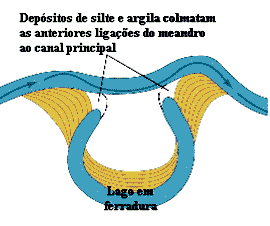
No ponto de observação não é possivel visualizar uma formação desse tipo, mas pela sua evolução espectável é provavel que venha a ser um meandro abandonado. Na imagem abaixo podem ver a localização do meandro abandonado de Janeiro de Cima, ja formado:
Segundo A. CHRISTOFOLETTI (1981, p. 292) “Os meandros encaixados aparecem quando a escala do meandramento do canal é semelhante à do seu vale. Os meandros devido ao soerguimento (tectónica), ou ao abaixamento do nível de base (eustasia) vão 48entalhando as camadas subjacentes. Na perspectiva Davisiana os meandros encaixados são sinais de rejuvenescimento das paisagens”.
Segundo THORNBURY (1969) os meandros idênticos aos do Zêzere podem ser do tipo “em que o rio entalha verticalmente resultando dai vertentes quase idênticas para ambos os lados; e os que sofreram um deslocamento, redundando em vertentes mais íngremes nas concavidades do vale meândrico e em vertentes mais suaves nas convexidades. Nesta situação é provável que o aumento da sinuosidade ocorreu durante o entalhamento”
Para registar esta Earth cache vão ter de responder as seguintes perguntas e enviar-me as respostas. Todos os log devem enviar as respostas, independentemente de fazer a EC em conjunto.
1. Por palavras tuas explica quais são os principais factores de formação e evolução dos meandros.
2. A velocidade do fluxo fluvial é maior no intradorso ou no extradorso do meandro?
3. O que poderá ocorrer ao meandro que estas a ver?
4. Admitindo que a secção mais larga do meandro tem cerca de 300m, estima a largura da parte mais estreita (Dica: usa metedos de aproximação como explicado aqui)
5. Usando o valor obtido na pergunta 4, e admitindo que o a erosão avança 0,2cm por ano em cada curva, estima o tempo que demora o meandro a se tornar num meandro abandonado.
6. No miradouro existe uma guarda de madeira. No prumo central da semi circunferencia, a guarda esta presa por quantos pregos?
7. Com o vosso log publiquem uma foto vossa com o GPS em frente ao Meandro, no miradouro. (facultativo)
Fontes:
* Carlos Neto de Carvalho Geólogo/Geologist
Coordenador Científico/Scientific Coordinator Geopark Naturtejo, UNESCO European and Global Geopark
* Wikipedia
* English text revision: Daniel Oliveira