Since the early days of radio experimentation (about 100 years ago), hams used to play a game, similar to present day geocaching, called DF Hunts. DF being the two-letter acronym for Direction Finding. One radio ham would hide a radio beacon and the others would set out to find it using various designs of directional antennas.
Homemade directional antennas were not precision instruments. They were able to read the direction to the beacon with an accuracy of about 10 degrees. This uncertainty meant that one had to move progressively closer to the beacon, taking new readings along the way until almost within sight of the beacon.
By taking just two readings from widely spaced fixed positions, one could, by means of triangulation, determine the location of the beacon. However, due to the 10 degree uncertainty, this only provided the approximate position of the beacon. More than two readings only helped slightly to improve the certainty of the beacon's position.
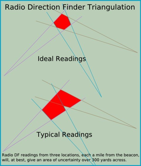
The only way to really make the area of uncertainty smaller was to get closer to the beacon.
My friend Masiah, who dissapeared mysteriously last year, was a perfectionist, he wanted to be able to pinpoint the location of the beacon to within a few yards radius by just taking three measurement from up to 2 miles away. And he did it with the equipment that he built way back in 1972. He designed the beacon himself. It did not simply send out pulses of radio waves, instead it was a transponder that listened for a certain radio signal and immediately replied by sending a short signal at a different frequency. He had in fact created a type of very-low-power radio distance measuring system. This could not be done with radar because, in addition to the extremely high power requirement, radar relies on receiving radio waves that were reflected from an object - it is therefore impossible to detect a small object that is surounded by other metal structures.
Masiah's device used signals in the VHF amateur band and had a measurement accuracy of plus or minus 10 nano-seconds. This meant that he could measure distances with an uncertainty of 10 feet. However, such accuracy was only achieved if the beacon was unobstructed by large objects such as the ground. Readings taken when out of sight of the beacon would be erratic and show a greater distance of up to 20%.
The equipment only measured the time related to the distance - not direction - thus more than one reading was required in order to determine the direction.
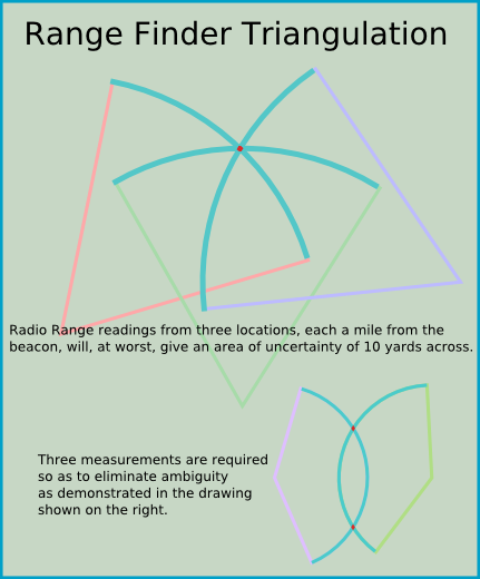
To be practical, one needed accurate maps to plot the arcs of distance so as to pinpoint the beacon where the arcs intersect. Accurate maps were (and still are) printed for purpose of air navigation but the scale of these charts are far too small to be of use in a treasure hunt and for this reason rangefinder hunts never caught on. But today we can print our own accurate maps from satellite images which are freely available on the internet.
Were it not for GPS, we might all now be geocaching with the help of range-finders!
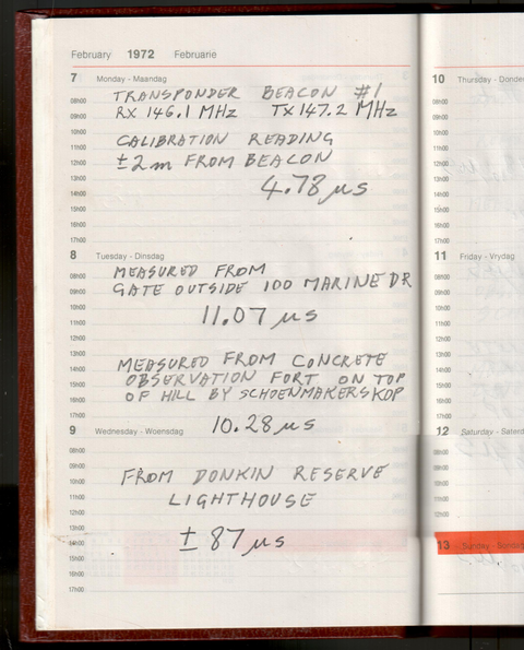
Among the old notes in which Masiah had made circuit diagrams of the transponder beacon and measuring tranceiver, I found a set of measurements for the location of his beacon. I also found a QSL card from a fellow ham thanking Masiah for the challenge but saying that he could not find a map with enough detail. My guess is that no one ever found the transponder beacon - do you suppose the beacon is still in place?

Reference data:
Speed of light in vacuum = 186282 mi/s (miles per second)
Refraction index of air at sea level = 1.00028
Distance per degree of latitude at 34 degrees latitude = 110.9km
Distance per degree of longitude at 34 degrees latitude = 92.38km