
This earthcache is located in an amazing site called :
"FALESIAS UM DOS MAIS VALIOSOS - ECOSSISTEMAS DA EUROPA - PARQUE NATURAL DO SUDOESTE ALENTEJANO E COSTA VINCENTINA - PRAIA DA AMOREIRA - ALGARVE"
The geological setting of the area is set amongst rocks of Lower Cambrian age but more specifically in the Brejeira Formation that is mostly made up of turbiditic deposits which in turn make up the Baixo Alentejo Flysch Group.
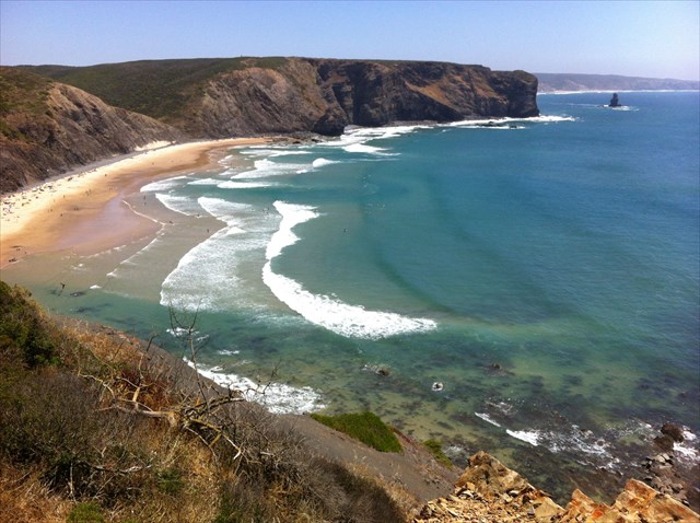
The geological explanation below describes various kinds of fold hinges and limbs that can be seen on earth as a result of volcanic eruptions, cataclysms and terrestrial globe upheavals. Here most kinds can be observed within a 500meters wide condensed area : vertical, horizontal, oblique, standing in half circle, flat curved, inversed S, even an old lava mouth, all on the beach !
At the end of this description, you will find the coordinates of 5 spots to visit on the beach where you will have to observe the hinges and limbs and determine their kind by selecting one of the proposed answers. Each answer has a number that you will have to substitute to ABCDE letters in the following virtual coordinates and enter in the geochecker. If your answers are correct, you will find in the geochecker a WORD to be used in your log to ascertain your success. This word can vary from time to time. So, no need to send emails, I will check the logs. Please preferably write your logs in English or French since I hardly understand Portuguese. Pictures are optionally welcome. Thanks.
Any non compliant log will be deleted
N 37° 21. 1 A B - W 8° 50. C D E
While fractures are the commonest expression of rock deformation, there can be no doubt that folds are the most spectacular (figure 1). The term fold is used in geology when one or a stack of originally flat and planar surfaces, such as sedimentary strata, are bent or curved as a result of plastic deformation and are the direct evidence of the existence of the tremendous forces which act upon the Earth's crust
Basic fold geometry and nomenclature
Fold hinge and limbs - If we consider a single folded surface (figure 1) the main elements of the geometry of the fold shape are firstly the hinge or closure, which is the zone of maximum curvature 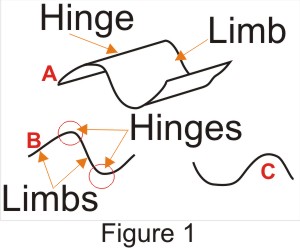 of the surface, and secondly the limbs, which are the areas between the hinges. If it is possible to define a line of maximum curvature, this line is called the hinge line. A single fold comprises a hinge and two limbs which enclose the hinge. In a series of folds, each limb is common to two adjacent folds. Depending on the actual shape of the fold, that is, on the way in which a surface changes curvature, the hinge may be very sharply defined and the limbs relatively straight (figure 1B), or the curvature may be more constant around the fold if it approaches a cylindrical shape (figure 1C). In a truly cylindrical fold, where the fold surface corresponds to part of the surface of a cylinder, neither hinge nor limb can be defined, but such examples are uncommon.
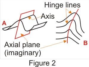 Fold axis and axial plane - In describing the attitude of a fold, it is useful to refer, not to the attitudes of both limbs, but to the imaginary plane which is equidistant from each limb and which bisects the angle between them. This plane is termed the axial plane and cuts the hinge zone of the fold along a line which is termed the fold axis (figure 2A). Provided that the limbs of a fold are sufficiently well defined, the determination of the orientation of axial plane and axis will give a precise description of the orientation of the fold. It must be remembered that these terms refer only to a single fold surface
Fold axial surface - When we consider a fold consisting of a number of fold surfaces, it is usually more convenient to define a single surface such that it passes through the hinge lines of each successive fold surface. Such a surface is in general not planar and is known as the fold axial surface (figure 2B). The hinge lines are not always easy to locate by eye if the hinge zone is broad and the method is only appropriate for relatively tight folds with well defined hinges.
Inter-limb angle - The smaller angle made by the limbs of a fold is termed the inter-limb angle or fold angle. The tightness or openness of a fold as expressed by this angle is a· useful method of classifying folds (figure 3A) and reflects the intensity of deformation.
 Amplitude and wavelength -These are convenient measures of the size of a fold. The easiest method of determining the wavelength of a fold is to measure the distance between the hinges on either side of the fold. If these are not visible, the half-wavelength may be measured instead by taking the distance between the two inflexion points on either side of the fold hinge. The inflexion points are where the sense of curvature changes from one fold into the next (see figure 3B). The amplitude or "height" of a fold may be measured by taking half the perpendicular distance from the hinge to the line between the two adjoining hinges or the perpendicular distance from the hinge to the line between the two inflexion points.
Fold orientation
The orientation of a fold may be measured in the field by obtaining the attitudes of both limbs, and if the limbs are relatively straight and regular this information is sufficient for a complete description of the fold attitude. However it is more convenient, and conveys more useful information, to describe and record folds in terms of their axial planes or surfaces, and axes. Thus on a map the position of a fold is shown by drawing the outcrop of the fold axial surface as a line. This line is termed the fold axial trace. The dip and strike of the axial plane or axial surface may also be plotted in the same way as for a bedding plane.
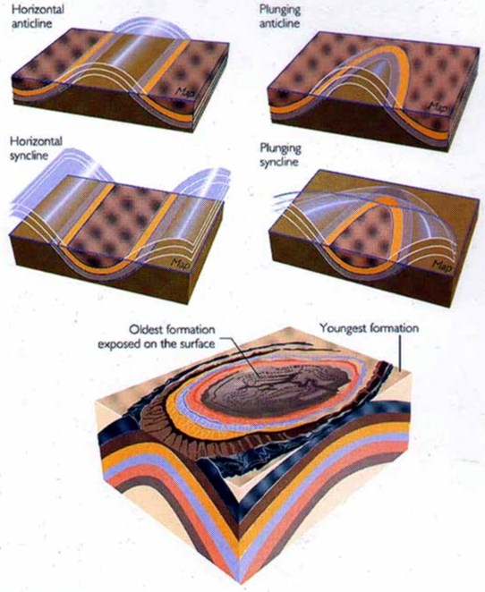
Fold plunge - The attitude of the fold axis is measured as the angle between the axis and the horizontal. This angle, which must be measured in a vertical plane (like the dip angle) is termed the plunge (figure 2.4), so that a complete description of the orientation of a fold axis is given as an amount and direction of plunge, for example, a fold plunges 30° towards (on a bearing of) 105°.
Classification of folds
The classification of folds is based on four main features or properties: (a) direction of closing, (b) attitude of axial surface, (c) size of inter-limb angle, and (d) nature of profile.
Closing and facing direction - Folds which close upwards, that is where the limbs dip away from the hinge, are termed antiforrns (figure 4A) and those which close downwards, where the limbs dip towards the hinge, are termed synforrns (figure 4B). Folds which close sideways are termed neutral folds (figure 4E). Under normal conditions where the bedding becomes younger upwards, an antiform will contain older rocks in its core and is then given the more familiar name anticline. Thus the term anticline should strictly be applied only to a fold with older rocks in its core (figure 4D). Conversely, a syncline is a fold which contains younger rocks in its core (figure 4E).
In areas of more complex folding, where strata are commonly 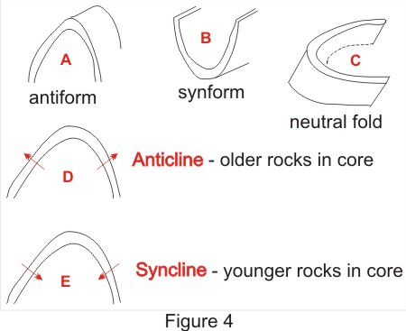 inverted, it is possible to find downward-closing anticlines or upward-closing synclines (figure 4F). In such areas it is convenient to speak of the facing direction of a fold, which is the direction along the axial surface in which the strata become younger. Thus in figure 4F, fold X is an anticlinal synform and fold Y is a synclinal antiform, and both folds face downwards since the strata are inverted. The main fold, W, with a sub-horizontal axial surface is a neutral fold, facing towards the left. Fold Z is an upward-facing (synclinal) synform.
Attitude of axial plane - Folds may be divided into three groups based on the dip of the axial plane or surface. Folds with steep to vertical axial planes are termed upright, those with moderately-dipping axial planes are termed inclined and those with sub-horizontal axial planes are termed recumbent (figure 5A-D). The division between these classes is not rigidly defined. Inclined folds where one limb is inverted are termed overfolds (figure 5C). In inclined folds the highest and lowest points on the fold surface do not in general correspond with the hinges and it is sometimes useful to use the terms crest and trough respectively for these positions.
Inter-limb angle - The size of the inter-limb angle measures the degree of tightness of a fold which reflects the amount of compression of the strata. Figure 3A shows a classification scheme which sub-divides folds into four classes: gentle (180°-120°), open (120°-70°), close (70°-30°), tight (30°-0°) and isoclinal (0°). These limits are not usually strictly adhered to. Precision is better achieved, if required, by stating the angle. Gentle folds are often termed flexures. Problems arise in measuring the fold angle where the limbs are not straight. In such a case tangents can be drawn to the curve at the point of inflexion (figure 3B). The inter-limb angle is the angle made by the two tangents.
Folds can furthermore be classified according to their profile- The fold profile is the shape of a folded layer observed in the plane perpendicular to the Fold axis. Folds exhibit considerable variation in profile, and since this variation partly reflects differences in the mechanism of formation a precise description of this profile is often very important. However, for the purpose of this earthcache, the above lesson will suffice.
Your tasks :
Based on the above definitions and diagrams, your mission is to characterise the folds that you see at the designated coordinates. Attached are some pictures to help you choosing the right answers but no indication to which spot they relate to.
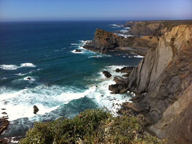
A.. From parking area indicated on top cache coordinates, go to N 37°21.162, W008°50.703. Here you face the sea and a rock wall typical of lava eruption. What shape are the hinges : Answer 1 = round and synform ; Answer 2 = square and neutral fold or Answer 3 = antiform and sharp-pointed. Choose one
B. Go to coordinates N 37°21.213 W 008°50.669. Here you turn your back on the sea and face an old and huge lava mouth forming a kind of cave. What shape are the plies : Answer 4 = vertical; Answer 5 = horizontal + plunging syncline or Answer 6 = oblique Choose one
C. Go to coordinates N 37°21.246 W008°50.677. Here you face a kind of barrier along the beach. What shape are the plies : Answer 7 = horizontal ; Answer 8 = vertical/oblique or Answer 9 = curved. Choose one.
D. Go to coordinates N 37°21.261 W 008°50.690. How are the plies ? Answer 1 = flat in half circle and neutral fold ; Answer 2 = flat and straight or Answer 3 = vertical in half circle and synform. Choose one
E. Last but not least, go to N 37°21.299 W 008°50.737. You face a huge platform in between the beach and the sea. What is its shape ? Answer 4 = flat and straight ; Answer 5 = neutral fold, flat and twisted in S shape or Answer 6 = neutral fold, flat and twisted in inversed S. Choose one
Should you have some more time left, I recommend you climb on the top of the cliff using the foot path starting from the parking. Your eyes will embrace this amazing site (and you may find a traditional geocache as well). Enjoy the scenic view !


Este earthcache é situado em um local surpreendente chamado :
"FALESIAS UM DOS MAIS VALIOSOS - ECOSSISTEMAS DA EUROPA - PARQUE NATURAL DO SUDOESTE ALENTEJANO E COSTA VINCENTINA - PRAIA DA AMOREIRA - ALGARVE"
As rochas expostas nesta localidade são sequências turbiditicas da Formação de Brejeira que faz por sua parte do Grupo de Flysh do Baixo Alentejo. A sua idade está balizada no Câmbrico inferior (Viseano - Namuriano).
A explicação geológica abaixo descreve vários tipos de dobras e flancos que podem ser vistos na Terra resultado de erupções vulcânicas, cataclismos e convulsões no seio do globo terrestre . Aqui a maioria dos tipos pode ser observado dentro de uma ampla área de 500 metros: dobras verticais, horizontais, oblíquas,etc.!
No final desta descrição, vai encontrar as coordenadas de 5 pontos para visitar na praia, onde terá que observar as dobras e os flancos e determinar o seu tipo , selecionando uma das respostas propostas. Cada resposta tem um número que terá que substituir a letras ABCDE nas seguintes coordenadas virtuais e entrar no Geochecker.
Se sua resposta estar correta, vai encontrar no Geochecker uma palavra obrigatoriamente tem de ser usada no seu log. Esta palavra varia ao longo do tempo. Entaõ, não hà necessidade de enviar e-mails mas vou verificar os logs ocasionalmente. Qualquer comentàrio a ser feito em Inglês ou Fancês mas não em Português que eu não entendo. Quadros são acolhimento de optionnally. Obrigado.
Qualquer não tronco correspondente será eliminado
N 37° 21. 1 A B - W 8° 50. C D E
Enquanto que as fracturas geológicas são a forma mais comun da expressão da deformação das rochas, as dobras são seguramente as mais espectaculares (figura 1). O termo dobra é usado em geologia quando um ou mais estratos que eram originalmente planos se encontram curvados ou dobrados devido à deformação plástica das rochas. As dobras são a evidência clara das forças que actuam na crusta terrestre.
Dobras e charneiras - Podemos considerar uma única superfície dobrada (figura 1) com os seus principais elementos de geometria. Em primeiro lugar a charneira (hinge), que é a zona de máxima curvatura da superfície, e por outro lado os flancos, o qual são as áreas entre as charneiras. Se é possível definir uma linha de maior curvatura, esta linha é chamada de linha de charneira. Uma dobra simples compreende uma charneira e dois flancos. Numa série de dobras, cada flanco é comum a duas dobras adjacentes
Eixo da dobra e plano axial - Ao descrever a atitude de uma dobra, é útil para se referir, não para as atitudes de ambos os flancos, mas ao plano imaginário que é equidistante de cada flanco e que corta o ângulo entre eles. Este plano é denominado o plano axial e corta a zona de charneira da dobra ao longo de uma linha que é denominado o eixo da dobra (figura 2A).
Superfície axial da dobra - Quando consideramos uma dobra que consiste de uma série de superfícies de dobras é geralmente mais conveniente para definir uma única superfície de tal forma que passa através das linhas de charneira de cada uma das superfícies de dobras sucessiva. Essa superfície geralmente não é plana e é conhecida como a superfície axial (figura 2B).
Ângulo Inter-flanco - O menor ângulo feito pelos flancos de uma dobra é denominado o ângulo inter-flanco ou ângulo de dobra. O aperto ou abertura de uma dobra, como expressa por este ângulo é um método útil de as classificar (figura 3A) e reflecte a intensidade de deformação
A amplitude e comprimento de onda - Estas são medidas convenientes para medir o tamanho de uma dobra. O método mais fácil de determinar o comprimento de onda de uma dobra é medir a distância entre os flancos de cada lado da dobra
Mergulho da dobra - A atitude do eixo da dobra é medido com o ângulo entre o eixo e a horizontal. Este ângulo, o qual tem de ser medido num plano vertical (como o ângulo de inclinação) é denominado o mergulho (figura 2.4), de modo que uma descrição completa da orientação de um eixo de dobra é dada com um valor e direcção de mergulho, por exemplo, uma dobra mergulha 30° para (orientação de) 105°.
Com base nas definições e diagramas acima apresentados, a sua missão é caracterizar as dobras que vê nas coordenadas designadas desta EarthCache. Em anexo estão algumas fotos para ajudá-lo a escolher as respostas certas , mas nenhuma indicação é dada a que ponto estas se relacionam .
A. . Da área de estacionamento indicada nas coordenadas do cache, vá para N 37 ° 21,162 , W008 ° 50,703 . Aqui, enfrentado o mar e uma parede de rocha típica da erupção de lava. De que formato são as charneiras das dobras?: Resposta 1 = redondas e em Sinforma ; Resposta 2 = quadrado ou em dobra neutra ou Resposta 3 = em antiforme e pontiagudas. Escolha um.
B. Vai para as coordenadas N 37 ° 21.213 W 008 ° 50,669 . Aqui você virar as costas para o mar e enfrentar uma velha e enorme boca de lava formando uma espécie de caverna. Deque forma são as camadas?: Resposta 4 = vertical; Resposta 5 = horizontal +sinclinal mergulhante ou Resposta 6 = oblíquo. Escolha um
C. Vá para as coordenadas N 37 ° 21,246 W008 ° 50,677 . Aqui você enfrenta uma espécie de barreira ao longo da praia . De que forma são as camadas : Resposta 7 = horizontal; Resposta 8 = vertical / oblíqua ou Resposta 9 = curvo. Escolha um.
D. Vá para as coordenadas N 37 ° 21,261 W 008 ° 50,690 . Como são as camadas ? Resposta 1 = Planas em formato de semi-círculo e dobra neutra; Resposta 2 = plana e reta ou Resposta 3 = vertical em semi-círculo e Sinforma . Escolha um
E. Por último, mas não menos importante, ir para N 37 ° 21.299 W 008 ° 50,737 . Você enfrenta uma enorme plataforma entre a praia e o mar. Qual é a sua forma? Resposta 4 = plana e reta ; Resposta 5 = dobra neutra, plana e torcida em forma de S ou Resposta = 6 Dobra neutra, plano e torcido em S invertido . Escolha um
Se você tiver um pouco mais de tempo de sobra, eu recomendo que suba ao topo do penhasco usando o caminho a partir do estacionamento. Seus olhos vão abraçar este site incrível (e você pode encontrar uma geocache tradicional também). Aproveite a vista panorâmica !
Note: all english text and technical figures adapted from: Park, R. G., 1983. Foundations of Structural Geology. Blackie. Glossário verificado pelo Professor J. Brandão Silva da Faculdade de Ciências da Universidade de Lisboa a quem se agradeçe a amabilidade.
And a special thank to my friend Daniel de Oliveira who kindly accepted to let me use the technical background of his GC17W0X Earthcache and helped me for the translation in Portuguese.

The Geological Society of America granted me the highest distinction of Earthcache Master Platinium