This 1.27 mile one way hike (that's 2.54 miles round trip) begins in Shades State Park (there is an entrance fee during the peak season), crosses SR 234, and ends in Pine Hills Nature Preserve. See additional waypoints for some extra information to help determine if you are up for the hike to get to the Honeycomb Rock formation. For 2/3 of the hike you'll be on a mostly flat packed dirt trail. That means when it's wet, expect to get a bit muddy. The last 1/3 of the hike (and the first 1/3 on the way back) requires climbing down and up wooden stairs that can get slippery when wet, some elevation changes, and crossing a shallow creek. PLEASE stay on all marked trails.
To Log This EarthCache
To demonstrate the educational value of your visit, please email me the answers to the following questions: (coachstahly) or the link at the top of the cache page to reach my profile, where you will see a link to Send message)
1. What is the approximate height of the sandstone rock cliffs in this section of the Pine Hills Nature Preserve?
2. The sandstone wall before you is from what geologic age or period?
3. The Honeycomb Rock you're currently standing underneath (and in front of) has been contained in a fixed area roughly 25x18 feet for as long as this preserve has been open to public visitation. Why hasn't the honeycomb weathering expanded beyond its current boundaries, either above, below, or to either side? Please combine site specific observations and information provided in the description to support your theory.
OPTIONAL! Please take a photo of yourself AND/OR your GPSr with the rock formation in the background. I understand that this may be difficult to do based on the height of the formations but please do your best.
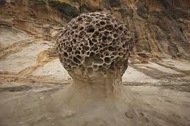
Honeycomb weathering occurs all over the world including deserts, Antarctic valleys, coastal areas, tropical environments, and right here at GZ in a temperate climate. It is most frequently found in coastal environments where the salt in the ocean or sea water is frequently mentioned, and believed to be, the causal factor that creates this interesting form of weathering. It occurs in many different types of rocks including sedimentary (the most common), crystalline igneous, and even volcanic rocks, spread throughout the world. There are many theories that have been proposed over the years to explain honeycomb weathering and with the exception of one (mostly due to where the honeycomb weathering is found), there is no accepted standard theory that is supported with scientific evidence that shows how honeycomb weathering forms.
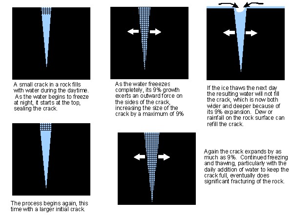
Some of the earliest known scientific theories examined honeycombed rocks in Corsica and initially determined that the formations were created due to wind erosion, with the "softer" elements being eroded away, leaving behind the harder sandstone honeycomb shapes. 40 years later, the next scientist that studied this physical phenomena determined that the formations were created instead by "microclimatic temperature variation", an idea that the colder air in the shady "holes" of the honeycomb is "displaced" by the warmer rising air currents, eventually weakening the softer material and causing it to "flake" away. Just 16 years later, another scientist believed that "frost shattering", the stresses on the different types of rock due to the freezing of water on the rocks and the subsequent weakening and erosion of softer material, in the long ago past created these same honeycomb features visible today.
The most commonly accepted theory proposed to explain honeycomb weathering is salt crystallization or haloclasty. The spray of salt water into the cracks and crevices of a stone formation susceptible to honeycomb weathering is the beginning of the formation of a honeycomb. The water eventually evaporates, leaving behind salt crystals in the cracks and crevices of the surface. As they heat up, the salt crystals expand, sometimes up to three times their original size, and exert pressure on the softer elements in the rock in question, leading to granular erosion (friction), NOT a chemical one (creation of an acid like mix that dissolves the softer rock). Wind, rain, high tides, and more salt water spray clear out the eroded material and also serve to continue the process of honeycomb weathering, creating larger and deeper formations.
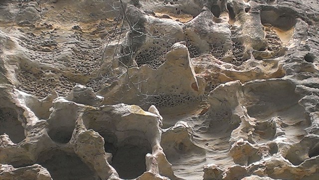
In non-salt water locations where honeycomb weathering has been noted (like right here at GZ), this theory, while still possible, doesn't fully support the proposed theory. While salt can still be transferred to the area in question by migrating fluids (rain or evaporation) or may even be present in the original sediment, it wouldn't allow for repeated exposure to haloclasty unless the rain or evaporated water contained high concentrations of salt, an unlikely occurrence in the middle of the large land mass you're currently standing on. Instead, scientists believe that there are a variety of factors at work. Algae, fossilized in the Mississippian Age sandstone before you, created small pockets of soft material amidst all the harder sandstone. The outermost layer was eventually eroded away due to wind, rain, and other erosion factors that contribute to weathering, leaving behind a small cavity surrounded by the harder sandstone. Once the outer layer was removed, the next layer was weathered away, and then the next, and so on and so on, eventually creating the formation you currently see above you.
For more information about the Pine Hills Nature Preserve, click on the Related Web Page link above (just below the cache size). Most information presented here taken from G. E. Mustoe, 1981 study, found online at this address - http://www.tafoni.com/Bibliography_files/Origin%20of%20Honeycomb%20Weathering.pdf
For more information, use the following link. http://www.nature.org/ourinitiatives/regions/northamerica/unitedstates/indiana/placesweprotect/pine-hills.xml
