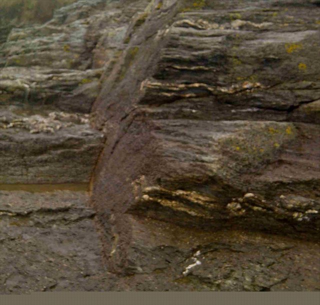
 Profitez d’une promenade sur le chemin côtier pour observer une petite faille et surtout un beau plan de fracturation recoupant les micaschistes environnants.
Attention à la marée !
 Enjoy a walk along the coastal path to observe a small falt and especially a beautiful plane intersecting fracture the surrounding mica.
Attention to the tide!
 Genießen Sie einen Spaziergang entlang der Küste zu einer kleinen falt beobachten allem ein schönes Flugzeug und schneidenden Bruch die Umgebung Glimmer.
Aufmerksamkeit auf die Flut!
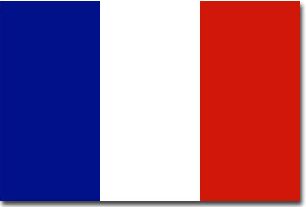
Suivez la direction donnée par le GPS sur le banc, pour vous rendre au premier point. (waypoint N 47°07.508 W 002°13.122 )
Matériel pour pouvoir répondre aux différentes questions : une boussole (ou votre GPS en mode boussole), un mètre ruban (ou un double décimètre), un clinomètre (ou un rapporteur), un cerveau muni de ses neurones, en ordre de marche !
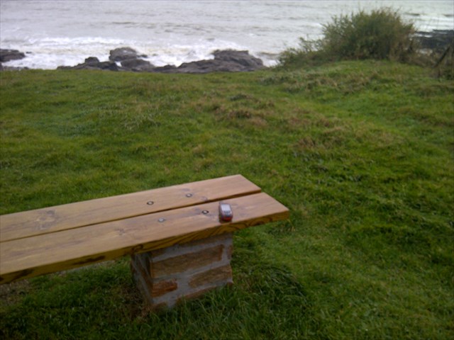
Vous êtes désormais devant une petite faille : Point 1 : N 47°07.499 W002°13.130
Attention à la marée !!
Il sera très préférable de descendre à marée basse sur l'estran pour réaliser les mesures et les tests.
Pour valider votre visite sur le site, envoyez-moi vos réponses par courrier électronique aux quatre questions suivantes :
Question 1: D’après la photo 1, quelle est la valeur h que vous mesurez ?
Question 2: à une distance de 1.35 mètre de la paroi, au sol, vous devez trouver un trou. Quelle est sa forme ? Carré, triangulaire, ou circulaire ?
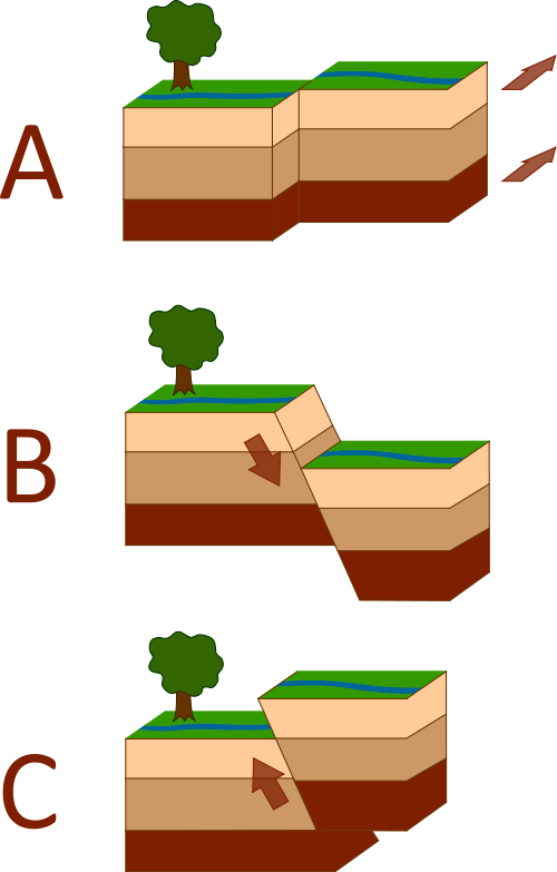
Question 3: Le trait jaune figure la petite faille sur la photo 1, à quel type de faille appartient celle-ci (pour aider, un “traceur“ de quartz a été surligné en vert) ? Faille décrochante (type A), Faille normale (type B), ou Faille inverse (type C) ?
Rendez-vous au second waypoint, pour continuer à observer. Point 2: N47°07.494 W002°13.120
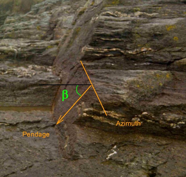
Nous allons maintenant voir comment les géologues décrivent un plan dans l’espace… mais ce doit être bien compliqué ? Non, pas du tout, observez bien le schéma ci-dessous :
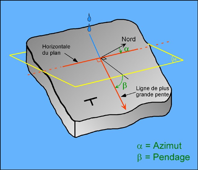
Le géologue français (c’est un peu différent pour les anglo-saxons) décrira le plan comme suit : N a (alpha), b (beta) direction .
L’azimuth a (alpha) se mesure en Angle d’une horizontale avec le Nord (strike direction).
Le pendage b (béta) se mesure comme un angle avec l’horizontale (90° = vertical) ; comme on ne dispose alors que d’un angle entre 0 et 90°, il faut aussi préciser « de quel coté » se situe le pendage.
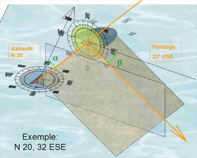
Voici un exemple de mesure d’un plan qui sera noté N 20, 32 ESE, ce qui se lit Nord 20 degrés plongeant de 32 degrés vers l’Est Sud Est.
N a (alpha), b (beta) direction
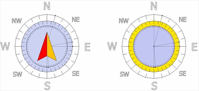
Question 4: Après avoir effectué les mesures de l’azimuth et du pendage comme décrit précédemment, donnez-moi la notation du plan de fracture qui est devant vous. Si la boussole de votre GPS n’est pas très précise, vous pourrez imprimer au préalable l’image ci dessous, qui vous permettra de gagner en précision. Le cercle extérieur est gradué de 15 en 15°, le cercle intermédiaire est gradué de 10 en 10° et enfin le cercle intérieur est gradué de 5 en 5°.
Une photo de vous aux environs du plan de fracture sera la bienvenue.
Follow directions given by the GPS on the bench to get the first point. (waypoint N 47°07.508 W 002°13.122 )
Equipment to respond to different questions: a compass (or your GPS compass mode), a tape measure (or a double decimeter ) , a clinometer ( or a reporter ) , having a brain of its neurons , in working order !
You are now in front of a small flaw : Point 1 : N 47°07.499 W002°13.130
Attention to the tide !
It will be very best to get off at low tide on the foreshore to perform measurements and tests.
To validate your visit to the site , send me your answers via email to the following four questions:
Question 1: According to the picture 1 , what is the value h you measure ?
Question 2: at a distance of 1.35 m from the wall , the ground, you have to find a hole. What shape is it ? Square, triangular or circular ?
Question 3: The yellow line include the small flaw in Photo 1 , what type of fault it belongs (to help a " tracer " quartz was highlighted in green) ? Slip fault (type A) , normal Faille (type B) , or reverse faults (type C)?
Go to second waypoint to continue to observe. Point 2: N47°07.494 W002°13.120
We will now see how geologists describe a plane in space ... but it should be complicated ? No, not at all, observe well the diagram below :
The French geologist ( this is a little different to the Anglo-Saxon ) described the plan as follows : N a (alpha) , b (beta) direction.
The azimuth a (alpha) is measured in a horizontal angle with the North ( strike direction).
Dip b (beta) is measured as an angle with the horizontal (90 ° = vertical ) as it is then available as an angle between 0 and 90 ° , we must also specify " what next " dip is .
Here is an example of measuring a plan that will be denoted by N 20 32 ESE , which reads North 20 degrees dipping 32 degrees to the South East East .
N a(alpha) , b(beta) direction
Question 4: After completing the measurements of azimuth and dip as described above , give me the rating of the fracture plane in front of you. If the compass of your GPS is not very accurate, you can print the first picture below , you will gain precision. The outer circle is graduated from 15 in 15 °, the middle circle is graduated from 10 to 10 ° and finally the inner circle is graduated in 5 to 5°.
A photo of yourself near the fracture plane will be welcome.
Folgen Sie den Anweisungen von den GPS auf der Bank gegeben , um den ersten Punkt zu gelangen.
Ausrüstung zu verschiedenen Fragen zu beantworten: ein Kompass (oder Ihr GPS-Kompass -Modus) , ein Maßband (oder ein Doppel Dezimeter ), ein Neigungsmesser (oder ein Reporter ), mit einem Gehirn seine Nervenzellen , in Ordnung !
Sie befinden sich nun vor einem kleinen Schönheitsfehler :Point 1 : N 47°07.499 W002°13.130
Aufmerksamkeit auf die Flut !
Es wird sehr am besten sein, steigen Sie bei Ebbe an der Küste , Messungen und Tests durchzuführen.
Um Ihren Besuch auf der Website zu überprüfen , schicken Sie mir Ihre Antworten per E-Mail auf die folgenden vier Fragen :
Frage 1: Entsprechend der Abbildung 1 , was ist der Wert h messen Sie?
Frage 2: bei einem Abstand von 1,35 m von der Wand , dem Boden , haben Sie , um ein Loch zu finden. Welche Form ist das? Quadratisch, dreieckig oder kreisförmig ?
Frage 3: Die gelbe Linie sind die kleinen Fehler in Photo 1, welche Art von Fehler es gehört ( zu helfen, ein " Tracer " Quarz wurde grün markiert ) ? Slip- Fehler ( Typ A) , normal Faille (Typ B) oder Rückwärtsfehler (Typ C) ?
Zum zweiten Wegpunkt weiter zu beobachten. Point 2: N47°07.494 W002°13.120
Wir werden nun sehen, wie Geologen beschreiben eine Ebene im Raum ... aber es kompliziert sein sollte ? Nein, gar nicht, beobachten auch die folgende Abbildung :
Die Französisch Geologe (dies ist ein wenig anders als die angelsächsischen ) beschrieben den Plan wie folgt : N a (alpha) ,b (beta) Richtung .
a (alpha) Das Azimut wird in einem horizontalen Winkel in den Norden ( Streichrichtung ) gemessen.
Die b (beta) dip als Winkel mit der Horizontalen (90 ° = vertikal) gemessen, wie wir das tun, dann hat einen Winkel zwischen 0 und 90 ° , müssen wir auch festlegen, " was nun " dip ist . Also, in welche Richtung ?
Hier ist ein Beispiel für einen Plan, der die Messung von N 20 ESE 32 bezeichnet werden , die Nord 20 Grad 32 Grad Eintauchen in die Süd-Ost- Ost liest .
N a(alpha) , b(beta) Richtung
Frage 4: Nach Abschluss der Messung von Azimut und Neigungswinkel , wie oben beschrieben , gib mir die Bewertung der Bruchebene vor Ihnen . Wenn der Kompass des GPS ist nicht sehr genau , können Sie das erste Bild unten zu drucken, werden Sie Präzision zu gewinnen. Der äußere Kreis wird aus 15 in 15 ° absolviert, wird der mittlere Kreis von 10 bis 10 ° und schließlich der innere Kreis ist in 5 ° 5 graduiert.
Ein Foto von sich selbst in der Nähe der Bruchebene sind willkommen.
 Rappel concernant les « Earthcaches »: Il n'y a pas de conteneur à rechercher ni de logbook à renseigner. Il suffit de se rendre sur les lieux, de répondre aux questions ci-dessus et de nous renvoyer les réponses.
 Reminder on "Earthcaches" There is no container or logbook to find information. Simply visit the site, to answer questions above and send us the answers.
Vous aimez les earthcaches, mais alors, si ce n'est pas déjà fait, qu'attendez-vous pour vous inscrire ? C'est ici: http://coord.info/GC5HKV6
ou consulter le site dédié, c'est là: