NOTE that there is an entrance fee to the Parco Della Rocca and it is not open during the winter months or 24/7
The geological features in the present-day Mediterranean essentially result from two major processes:-
(1) the tectonic displacement caused by the subduction of the African plate underneath the Eurasian plate and
(2) the progressive closure of the Mediterranean sea involving a series of submarine-insular sills.
The development of the Mediterranean basin began with the breakup of the Pangea supercontinent in Mesozoic times. In Triassic times, sea-floor spreading triggered the development of the Atlantic ocean, separating the African and Eurasian plates from the North American plate. Elsewhere sea-floor spreading separated the African plate from the Eurasian causing the development of the Tethys ocean. In the late Cretaceous period, these African and Eurasion plates began to converge, closing the Tethys ocean basin. The remnants of this ancient ocean are now called the Mediterranean Sea.
The slow contraction of the vast ocean between Africa and Eurasia in the last 50 million years has pushed the predominantly limestone sea bed of the Cretaceous period toward the surface, causing the formation of mountain and hill ranges in the north of Sicily. This orogenic squeezing has also been accompanied by volcanic activity, making Sicily rich in tuff (lithified volcanic ash) which is widely used for building materials. This is also characterized by the formation of precipitated sulfur, which had enormous importance to the economy of the island until the 1970s.
In the north east of the island Mount Etna is the largest active volcano in Europe and the second most active in the world, standing around 3,350 metres (10,950 ft) high (though this varies with summit eruptions). Along the northern coast, from east to west, stretch the Peloritans, the Nebrodi & the Madonie mountains, whose peaks go up to 2000 metres. Just west of the river Torto, the Madonie give way to irregular calcareous formations, isolated or in groups, dominating roundish low hills. Further south, in the eastern part of the island, there is a succession of tablelands formed by lava, tufa and calcareous rock, deeply carved out by gorges formed by erosion by water. In the centre of Sicily is the hilly sulphur-bearing plateau between 500 and 700 metres high, rising to 1000 metres at the hill on which Enna stands.
Cephalu is dominated by La Rocca, a huge mass of rock rising 270 metres above sea level, which the town moved up to for protection against pirate raids after the fall of the Roman empire. You have to climb the steep path to the listing co-ordinates at 150 metres above sea level, where there is an imposing building built of huge blocks of the local rock.
Q1) What sort of rock is it?
Q2) There are many fossils present in some of these blocks. Tell me what sort of fossils these are. Note that one of the information panels much lower down near the entrance to the rocky fortress tells you this and actually gives you the names of the two commonest genera
Q3) Thanks to its natural impregnability the locals could withstand long sieges up on La Rocca but to do so required a water supply which they derived from 19 wells or cisterns. The one at 135 metres above sea level (N38 02.230 E014 01.486) is huge. Use the notice board nearby to tell me its length, breadth and depth.
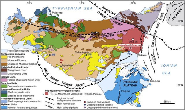
Q4) The map shows the area around Cefalu to consist of "Oligocene flysches and Silicide pelagic shales and flysches". Look up and tell me what is a "flysch" and how is it formed?
As you descend from La Rocca look at the walls of the fortified gateways and you should see blocks of one of these flysche deposits. What type of rock is it?
For the final question you have to go to the rocky path that skirts the rocky shoreline, just a metre or so above the sea. At N38 02.454 E014 01.698 you should see another rock containing lots of fossils.
Q5) What sort of fossils are these?
You may log your “find” as soon as you email me your answers, together with your e mail address. I will contact you as soon as possible to let you know if they are correct.
Please feel free to post a photo of yourself or any feature which is not a ‘spoiler’.
GOOGLE ITALIAN
Questo earthcache osserva alcune delle rocce in alto e in basso sotto l'affascinante città di Cefalù e richiede un bel po' di lavoro per le gambe perché per completarlo devi visitare le coordinate dell'elenco non lontano dalla cima della Rocca (N 38° 02.300 E 014° 01.500), un vecchio pozzo a N 38° 02.230 E 014° 01.486 PLUS N38 02.454 E014 01.698 sul litorale roccioso sotto il paese.
NOTA che l'ingresso al Parco Della Rocca è a pagamento e non è aperto durante i mesi invernali o 24 ore su 24, 7 giorni su 7
Le caratteristiche geologiche della attuale Mediterraneo derivano essenzialmente da due processi principali : -
( 1) lo spostamento tettonico causato dalla subduzione della placca africana sotto la placca eurasiatica e
( 2 ) la chiusura progressiva del Mediterraneo che coinvolge una serie di sottomarini insulare davanzali .
Lo sviluppo del bacino del Mediterraneo ha avuto inizio con la rottura del supercontinente Pangea in tempi mesozoici . Nei tempi del Triassico , diffusione del fondo marino innescato lo sviluppo del l'oceano Atlantico , che separa la placche africana ed eurasiatica dalla placca nordamericana . Altrove diffusione del fondo marino separato la placca africana dal eurasiatica che causa lo sviluppo della Tetide . Nel tardo periodo Cretaceo, questi piatti africani e Eurasion cominciarono a convergere , la chiusura della Tetide bacino oceanico . I resti di questo antico oceano sono ora chiamati sul Mar Mediterraneo .
La lenta contrazione del vasto oceano tra l'Africa e l'Eurasia negli ultimi 50 milioni anni ha spinto i fondali prevalentemente calcarea del Cretaceo verso la superficie , causando la formazione di catene montuose e di collina nel nord della Sicilia . Questo spremitura orogenico è stato anche accompagnato da attività vulcanica , rendendo la Sicilia ricca di tufo ( Lithified cenere vulcanica ), che è ampiamente utilizzato per materiali da costruzione . Questo è anche caratterizzata dalla formazione di zolfo precipitato , che ha avuto enorme importanza per l' economia dell'isola fino al 1970 .
Nel nord est dell'isola, l'Etna è il vulcano attivo più grande d'Europa e il secondo più attivo del mondo , in piedi intorno a 3.350 metri ( 10.950 piedi ) di altezza (anche se questo varia con eruzioni sommitali ) . Lungo la costa settentrionale , da est a ovest , allungare i Peloritani , i Nebrodi e le Madonie , le cui vette raggiungono i 2000 metri . Appena ad ovest del fiume Torto , il Madonie lasciano il posto a formazioni calcaree irregolari , isolati o in gruppo, dominare basse colline tondeggianti . Più a sud , nella parte orientale dell'isola , vi è una successione di altipiani formato da lave , tufo e roccia calcarea , profondamente scavata da gole formate da erosione da acqua . Nel centro della Sicilia, è il pianoro collinare zolfo - cuscinetto tra i 500 ei 700 metri di altezza , che salgono a 1000 metri presso il colle su cui sorge Enna .
Cephalu è dominato da La Rocca , una massa enorme di roccia in aumento a 270 metri sul livello del mare , che la città spostato fino a per la protezione contro le incursioni dei pirati , dopo la caduta dell'impero romano . Si deve salire il ripido sentiero per la quotazione coordinate a 150 metri sul livello del mare , in cui vi è un imponente edificio costruito di enormi blocchi di roccia locale.
Q1 ) Che tipo di roccia è?
Q2 ) Ci sono molti fossili presenti in alcuni di questi blocchi . Dimmi che tipo di fossili sono questi . Si noti che uno dei pannelli informativi molto più in basso, vicino all'ingresso della fortezza rocciosa ti dice questo e in realtà ti dà i nomi dei due generi più comuni
Q3 ) Grazie alla sua inespugnabilità naturale i locali potevano resistere a lunghi assedi su La Rocca , ma di fare in modo richiesto una fornitura di acqua che essi derivano da 19 pozzi o cisterne . L' uno a 135 metri sul livello del mare ( N38 02,230 E014 01.486 ) è enorme . Utilizzare la bacheca vicino per dirmi la sua lunghezza , larghezza e profondità .
Q4 ) La mappa mostra l'area intorno a Cefalù costituiti da " flysches Oligocene e Silicide scisti pelagici e flysches " . Guardate in alto e mi dica che cosa è un " flysch " e come si forma ?
Mentre si scende da La Rocca un'occhiata alle pareti delle porte fortificate e si dovrebbe vedere i blocchi di uno di questi depositi flysche . Che tipo di roccia è?
Per l' ultima domanda che devi andare al percorso roccioso che costeggia il litorale roccioso , appena un metro o poco al di sopra del mare . A N38 02,454 01,698 E014 si dovrebbe vedere un'altra roccia che contiene un sacco di fossili .
Q5 ) Che tipo di fossili sono?
Si può accedere il vostro " trovare " non appena si e-mail me le vostre risposte, insieme con il vostro indirizzo e mail. Mi metterò in contatto con appena possibile per farvi sapere se sono corrette .
Non esitate a postare una foto di te stesso o di qualsiasi funzione che non è un ' spoiler ' .