NOTE: the trail to the Point Buchon MPA is located on private property. Stay on trail at all times. Trail is open Thursday to Monday from 0800 to 1600 during daylight savings and 0800 to 1700 during summer hours. No pets on the trail. The trail is a 1.8 mile loop, level, easy to hike, and contours the coastal bluff. Bring your binoculars and camera!
The Chumash (local Native Americans) considered the Point Buchon headland a very spiritual site and those that live near this spectacular section of the coastline know it as “The Jewel of the Central Coast.”
Park at Waypoint #1 and hike to Waypoints 2,3, & 4.
Waypoint #1: Coon Creek parking lot N 35 15’29” W 120 53’14” A = How many picnic tables are there near the parking lot? Plus 1
Waypoint #2: Walk down the coast towards the gate and continue until you reach the bridge. B = How many fish do you see on the Coon Creek interpretive sign? Minus 2
Waypoint #3: Stop by the gatekeeper station and sign your waiver, inform them that you are geocaching to learn more about “Marine Protected Areas” and then continue down the trail to Coon Creek Beach. C = How many harbor seals are on the interpretive sign?
Waypoint #4: Continue along the trail to the Point Buchon headland. D=How many benches are located at this site? Plus 1
Continue on the loop back to the gatekeeper station. You have walked approximately 1.8 miles. Inform the gatekeepers that you have completed your search and were able to view the Point Buchon MPA.
Cache is hidden here: N 35 15’AB W 120 53’CD - substitute the answers above for the letters in the coordinates
By the way, answers for A+B+C+D = 6
California's Underwater Parks
In December 2012, California became an international leader in ocean protection by completing the United States’ first statewide network of marine protected areas (MPAs). Like the nation’s parks, forests and wilderness areas protect wildlife and habitats on land, MPAs protect and restore unique areas of the ocean. California’s MPAs come in many “flavors”; the size and level of protection, including fishing restrictions, can vary from one area to the next. Also called underwater parks or “Yosemites of the Sea”, they’re designed to protect plants and animals within an entire ecosystem, rather than protecting just a single species and ensure healthy, vibrant ocean life for generations to come.
California’s MPAs safeguard critical ocean habitat, allowing sensitive marine communities such as rocky reefs and seagrass beds to thrive and recover. They also protect biodiversity hotspots and important foraging grounds that support numerous species of fish and invertebrates, as well as seabirds and marine mammals. This in turn benefits a wide range of species including plants like bull kelp, invertebrates like sea stars, and marine mammals such as seals and otters. As safe havens, underwater parks offer a home and refuge for Big, Old, Fertile, Female (BOFF) fish to recover, grow and replenish our ocean.
MPAs are a "network of underwater nurseries"!
The central coast region of California was the first of the four coastal regions to establish a network of MPAs. Underwater parks in the central coast protect areas like the iconic Point Lobos, winding waterways of Elkhorn Slough, the tidepools of Natural Bridges, the elephant seal rookery at Piedras Blancas and many more important marine environments! Altogether, 29 MPAs were designated from Pigeon Point in the north to Point Conception in the south. These MPAs represent approximately 204 square miles (18%) of state waters within the region with approximately 85 square miles (7.5%) designated as "no take" state marine reserves. These MPAs went into effect in 2007.
Check out Central Coast MPA Tour. And while you're at it, check out North Coast MPA Tour. Based on Google Earth and requires 3D plug in for your browser; follow instructions.
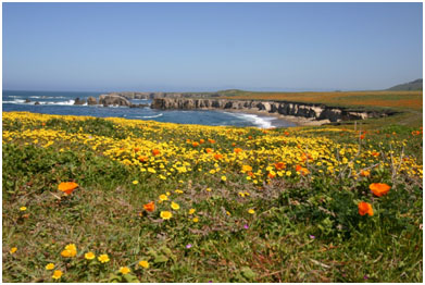
Point Buchon SMR and Point Buchon SMCA
Point Buchon is a prominent westerly headland with many caves, offshore rocky pinnacles and underwater reefs that provide habitat for an extraordinary high diversity of marine life. The reefs are home to more than 700 species of invertebrates, as well as 120 fish species, marine plants, seabirds, and marine mammals.
Point Buchon SMR, between Coon Creek and just north of Diablo Canyon Power Plant, is a must see. Once inaccessible, it’s been open to the public for about five years. Drive to the end of Montaña de Oro State Park in Los Osos and park in the last lot. Walk the bridge over Coon Creek and register at the PG&E kiosk for one of the best 3.5 mile coastal hikes in California! There’s no beach access and you are required to stay on the trail, but the sea arches, sea stacks and rocky points along this wave-battered coast are breathtaking. No fishing or harvesting is allowed.
Point Buchon SMCA sits offshore from Point Buchon SMR and can be reached by boat from Morro Bay. From the water you can see the rugged, rocky hills on land. This MPA only allows for the recreational and commercial take of salmon and albacore.
Explore California's Underwater Parks without getting your feet wet through new online tours!
Based on Google Earth and requires 3D plug in for your browser; follow instructions.