Når man bor i Helsingør kan man ikke undgå, at bemærke at det går meget op når man skal ud af byen, med mindre man følger Strandvejen.
Langs hele Øresundskysten både syd og nord for Helsingør by ses de meget markante Litorinaskrænter (kystskrænter), som afslører Litorinahavets (stenalderhavets) oprindelige højde på 5-7 meter over den nuværende vandstand. Netop ved Helsingør ses dette meget tydeligt. Hele Helsingør Kommunes 21 km lange kyststrækning består af en 50-100 m bred bræmme af hævet havbund neden for en stejl, 20-40 m høj kystskrænt fra stenalderens Litorinahav. Dog er skrænterne nogle steder endnu højere.
Foran kystskrænterne ved Helsingør ligger næsten overalt en bred stribe af marint forland, som er dannet i takt med landhævningen gennem de seneste 5-6.000 år. I selve Helsingør by fornemmes kystskrænten tydeligt, hvor den afgrænser Erik af Pommerns middelalderby, der blev placeret for foden af skrænten på det marine forland.
Skrænterne blev skabt ved landhævning. Først i stenalderen (for godt 8000 år siden for at være mere nøjagtigt) overhaler havspejlsstigningen som følge af klimaforbedring og isafsmeltning landhævningen, og havet trænger ind over de laveste dele af specielt Vendsyssel, Hanherred og Østhimmerland, men også ind over mange andre kystnære og lavtliggende egne af Danmark. Mens i andre dele af landet hæves landet og nye landområder dannes. Landhævningen i Danmark betyder at hele landet vipper over en akse af grundfjeld som går fra Ringkøbing ind over Fyn og videre til Køge. Landhævningen startede da ismasserne fra istidens enorme lag forsvandt og har fortsat lige siden.
Stenalderhavet måtte til sidst vige for landhævningen. Og hermed blev den helt specielle kystlinie ved Helsingør dannet. De steder man i dag kan forvente at finde den gamle stenalderhavbund, der kaldes Litorina-flader efter den boreale snegl Littorina littorea. Tegningen her viser en skematisk fremstilling af kystprofilen ved Helsingør:
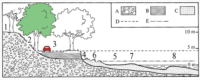
1. Morænelandskabets overflad. 2. Stenalderhavets kystklint. 3. Stenalderhavets havstok med Strandvejen. 4. Aktuel kystklint. 5. Strandbred. 6. Klitter. 7. Strandvold. 8. Revle.
A. Moræne. B. Stenalderhavbund. C. Sand. D. Stenalder-højvande. E. Nutids-højvande.
Flere steder er kystskrænten gennembrudt af V-formede erosionsdale, der går ned til Øresund, respektive af større vådområder, hvor stenalderhavet oprindelig har dannet større vige ind i landet, tydeligst f.eks. ved engen bag Egebæksvang Kirke i Espergærde, hvor en oprindelig vig strakte sig helt ind til Kystbanens nuværende forløb. Erosion er den fjernelse af materiale, som sker på grund af naturligt slid på landskabet. Erosion kan skyldes flere, eventuelt samvirkende årsager såsom is, slibning, syre, vand eller vind.
Litorina-fladerne med Strandvejen nedenfor skrænterne er et område, der er under konstant angreb af hav og vind. Mange steder langs kysten er det nødvendigt at sikre og beskytte kysten mod havet. Men stadig sker der store forandringer af kysten hele tiden. Strande forsvinder, nye kommer til, områder forsvinder i havet og nye områder kommer til. I december 2013 oplevede området den højeste vandstand i 100 år under stormen/orkanen med navnet Bodil. Stormen pressede store mængder af vand ned gennem Øresund. Vandet stod mellem 1,60 og 1,97 meter over normalt niveau. Det betød at Litorina-fladerne blev oversvømmet og nogle steder nåede vandet helt til foden af Litorina skrænterne. Flere steder forsvandt dele af kysten og ved Højstrup forsvandt, der også dele af Strandvejen. Huse og haver langs kysten blev oversvømmet. På billedet her som er taget under stormen ses Gummistranden ved Helsingør. Litorinaskrænten er ved de træer som kan ses i baggrunden:
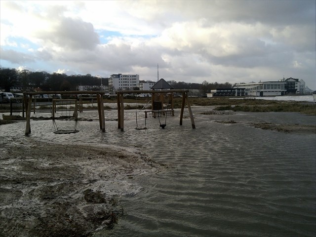
Stormen/orkanen Bodil viste tydeligt, hvor sårbart et område Litorina-fladerne er.
Sådan logger du cachen:
For at logge denne earth cache skal du besøge flere steder langs skrænterne bl.a. 3 erosionsdale. Hvis du følger rutebeskrivelsen får du alle tre erosionsdale at se fra begge ender, hvilket kan hjælpe dig med at besvare spørgsmålene. Turen er ca. 2,2 km lang fra start og tilbage igen.
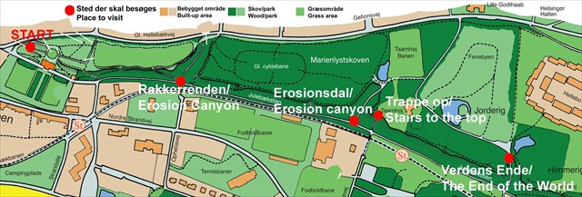
Start på N 56° 02.491 E 012° 36.132 og følg derefter skrænten oppe i parken. Gå ned ad stien ved N 56° 02.594 E 012° 35.951 til bunden af Rakkerrenden N 56° 02.623 E 012° 35.889 (den første erosionsdal).
Følg stien mod nord på det flade område langs skrænten til en stor signalmast N 56° 02.782 E 012° 35.668 (bagved er den anden erosionsdal).
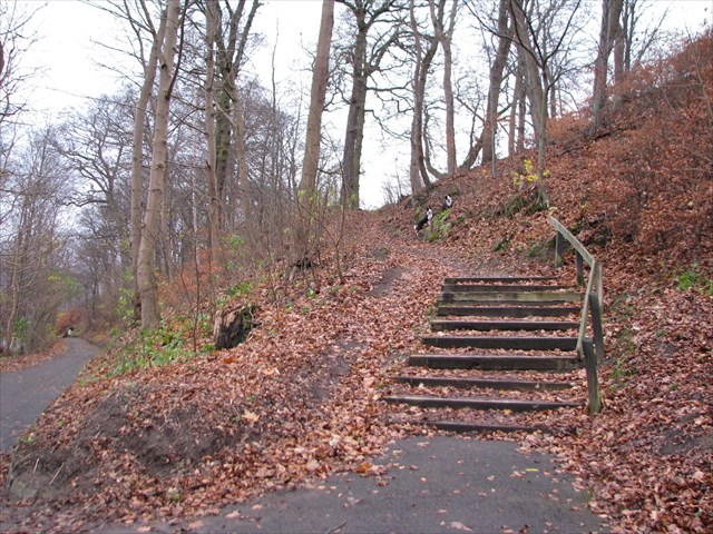
Gå op på toppen ad trappen ved N 56° 02.815 E 012° 35.643 og følg skrænten videre til Verdens Ende (som den tredje erosiondal hedder) ved N 56° 02.930 E 012° 35.445. Det er tilladt at gå langs plænen ved feriebyen. Gå ned igennem Verdens Ende og følg stien langs skrænten tilbage til Rakkerrenden og gå op igennem den og så er du næsten tilbage ved start.
Undervejs bedes du løse følgende opgaver:
Opgave 1: Ved N 56° 02.491 E 012° 36.132 - Her står du på et meget markant højdepunkt i Kongens Have med en fantastisk udsigt til Sverige og over Litorina-fladerne, hvor bl.a. Marienlyst Station, hotellet og campingpladsen på Gummistranden kan ses. Beskriv hvordan du tror Litorina-fladerne vil udvikle sig over de næste 100 år? Venligst begrund dit svar.
Opgave 2: Du skal besøge i alt 3 erosionsdale og sammenligne dem. Beskriv f.eks. forskelle, udformning, bredde, specielle kendetegn m.m. Hvordan tror du disse dale er opstået?
Opgave 3: Ved N 56° 02.815 E 012° 35.643 - Her står du ved et af de højeste steder på skrænten. Du skal op på toppen. Fra toppen har du bl.a. udsigt til Højstrup station. Venligst beskriv skrænten på dette sted f.eks. skræntens udseende, højde, hældning, specielle forhold på toppen, samt hvad du ser nedenfor skrænten.
Efter dit besøg på skrænten bedes du sende dine svar på alle spørgsmålene til CO (via min profil på geocaching.com) og her efter kan du logge cachen. Jeg kontakter dig, hvis der er problemer med dine svar.
Du er meget velkommen til at vedlægge billeder fra din tur i loggen, men det er ikke et krav.
Denne earth cache tager dig igennem bl.a. Kongens Have (læs evt. mere om parkens historie her). Parken indeholder mange spændende historier.
Kilder og referencer:
Helsingør Leksikon
Skov- og Naturstyrelsen
Helsingør Kommune
Nordøstsjællands Geologi af V. Milthers
Danmarks Natur, bind 1, 3 og 4
Wikipedia

When living in Elsinore you can not help noticing that you are not able to leave the old part of town without going up unless you take the coastal road, Strandvejen.
All the way along the coast of the Sound (Øresund) both south and north of the town of Elsinore (Helsingør) you will see the very prominent Litorina slopes (cliffs) that reveals the original height of the Littorina Sea (Stone Age sea) of 5-7 meters above the current water level. Precisely at Elsinore this can be seen very clearly. Almost all of the 21 km long coastline of the Elsinore municipality consists of a 50-100 m wide buffer strip of raised seabed beneath a steep, 20-40 m high coastal cliff from the Stone Age Litorina sea. However, the slopes in some places are even higher.
In front of the coastal cliffs of Elsinore there is almost everywhere a wide strip of marine foreland formed in accordance with the land rising over the last 5-6,000 years. In the town of Elsinore coastal slopes can be seen very clearly where it delimits the medieval town founded by the Danish king Erik of Pomerania, which was located at the foot of the cliff on the marine foreland.
The slopes were created by the raising of the land. In the beginning of the Stone Age (for more than 8000 years ago to be more precise) the rise of the sea level due to climate improvement and ice melting overtook the raising of the land and the sea flooded the lowest part of especially Vendsyssel Hanherred and Østhimmerland, but also many other coastal and low-lying regions of Denmark. While in other parts of the country the seabed was raised and new land areas were formed. The ongoing land raising in Denmark means that the country tilts about an axis of bedrock extending from Ringkøbing over Fyn and on to Køge. The land raising started when the ice masses of the Ice Ages huge layer disappeared and has continued ever since.
The Stone Age Sea finally had to give way to the land raising. And with this, the unique coastline at Elsinore was formed. Places where we today can expect to find the old stone age seabed are called Litorina surfaces after the boreal snail Littorina winkles. The illustration here shows a schematic representation of the coastal profile at Elsinore:
1. Moraine landscape surface. 2. The coastal clif of the Stone Age sea 3. Stone Age seashore with the coastal road, Strandvejen. 4. Current coastal cliff. 5. Sea shore. 6. Dunes. 7. Beach ridge. 8. Sand bank.
A. Moraine. B. Stone Age seabed. C. Sand. D. Stone Age high tide. E. Present day high tide.
In several places, the coastal cliff is intersected by V-shaped erosion canyons/valleys that go down to the Sound, respective of large wetlands where Stone Age sea originally formed larger inlets into the country, one of the most evident examples of this is tre meadow behind Egebæksvang Church in Espergærde where an initial cove reached all the way to where the railway Kystbanen is today. Erosion is the removal of material, which happens due to normal wear and tear on the landscape. Erosion can result from multiple and possibly interacting causes such as ice, grinding, acid, water or wind.
The Litorina surfaces with the coastal road, Strandvejen, below the cliffs is an area under constant attack by sea and wind. Many places along the coast, it is necessary to secure and protect the coast towards the sea. But still there are great changes of the coast all the time. Beaches disappear, new ones appears, areas fall into the sea and new areas are added. In December 2013 the area eperienced the highest water levels in 100 years durting the storm/hurricane named Bodil. The storm forced large amounts of water through the Sound. The water was raised between 1.60 and 1.97 meters above normal levels. This meant that the Litorina surfaces were flooded and in some places the water reached all the way to the foot of Littorina slopes. Several places parts of the coast dispappeared and at Højstrup even parts of Strandvejen disappeared and left large holes in the road. Houses and gardens along the coast were flooded. In this picture taken during the storm you can see the beach at Elsinore. The Litorina slopes are the trees that can be seen in the background:
The storm/hurricane Bodil clearly demonstrated the vulnerability of Litorina surfaces.
How to log this cache:
To log this cache you will have to visit a number of places along the slopes for example 3 erosion canyons. If you follow the route description you will visit all 3 erosion canyons and look at them from both ends, which will help you to answer the questions. The route is about 2.2 km long from start and back again.
Start at N 56° 02.491 E 012° 36.132 and follow walk along the slopes in the park. Walk down the path at N 56° 02.594 E 012° 35.951 to the bottom of Rakkerrenden N 56° 02.623 E 012° 35.889 (the first erosion canyon).
Go north along the path on the flat area below the slopes to a very high signal tower N 56° 02.782 E 012° 35.668 (behind is the second erosion canyon).
Go up the stairs to the top at N 56° 02.815 E 012° 35.643 and follow the coastal cliff till you reach The End of the World (which is what the third erosion canyon is called) at N 56° 02.930 E 012° 35.445. It is allowed to cross the lawns. Go all the way through the End of the World and take the path back to Rakkerrenden and walk through this canyon. Now you are almost back to the start again. .
Along the route please answer the following questions:
Question 1: At N 56° 02.491 E 012° 36.132 – Here you are standing with a great view to Sweden and the Litorina surfaces, where you can see e.g. Marienlyst station, the hotel and the camping site at the beach. Describe how you think the Litorina surfaces will develop over the next 100 years? Please elaborate your answer.
Question 2: You must visit 3 erosion canyons and compare them. Describe e.g. their difference in shape, width, special characteristics etc. How do you think these canyons were made?
Question 3: At N 56° 02.815 E 012° 35.643 – here you are standing at one of the highest parts of the coastal cliffs. You have to go up the stairs. From the top you have a view of among other things Højstrup Station. Please describe the costal clifff at this point: characteristics of the cliff, slope, height, special conditions at the top and what you see below the cliff.
After your visit please send your answers to all the questions to my profile at geocaching.com. Then you can log your visit. You need not wait for my answer, just go ahead and log immediately. I will contact you if there are problems with your answers.
You are very welcome to upload pictures from you visit to your log, but that is entirely optional.
This earth cache takes you through the park/wood area called Kongens Have - The Kings Garden. The park has a very interesting history which you can read about here – the leaflet is unfortunately only in Danish.
TILLYKKE TIL EDAGEYR SOM BLEV FTF!