Hungarian Falls is located in Hubbell, MI, just a few miles from Hancock, MI. The Hungarian Falls Trail hike reveals a total of three beautiful waterfalls, along with other geologically significant features. The Upper Falls displays possibly the most interesting feature at Hungarian Falls: a glimpse into the geological past of the Keweenaw Peninsula.
Directions:
1. Before you leave check, the batteries in your GPS.
2. Familiarize yourself with your GPS so you can enter, label, and navigate to waypoint coordinates.
3. Answer the logging questions below.
Coordinates:
Location of the Upper Falls – 47°10.451’ N, 088°27.072’ W.
Background and History Information
Waterfalls all over the world are appreciated for their uniqueness and beauty. Geologically speaking, waterfalls are significant because they have an interesting past.
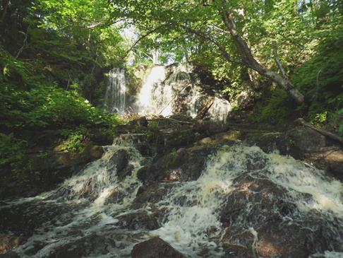
That is certainly the case for waterfalls all along the Keweenaw Peninsula. Here you see the highest of three falls found along the Hungarian Falls Trail. The three different rock types identified in this location present clues to understanding geological history of the Keweenaw.
Approximately 1.1 billion years ago, the Keweenaw was a place of active lava flows. These lava flows were created by a stage of rifting. The enormous weight of repeated lava flows and rifting caused the rock bed to sink, or sag. As the surrounding rock eroded away, it began to fill in where the sagging occurred. The older, igneous rock (basalt) was buried by younger sedimentary rock (conglomerate). This sequence repeated many times. Repetition of these sequences combined with tremendous pressure from the layers piling atop one another formed repeating layers of basalt and conglomerate rock. (Figure 1. Photo by A. Enstes)
Then, approximately 1.04-1.08 billion years ago, the landscape changed dramatically due to a plate collision along the Grenville tectonic zone. Because of the enormous compressional pressure created along the Keweenaw Peninsula, the rock bed was forced upward in a thrust fault. The force from the compressional action tilted the igneous rock bed, and offset the rock layers by as much as 3-5 kilometers. When this happened, the older layers of basalt were uplifted high above the surrounding sedimentary layers and left dipping toward the northwest.
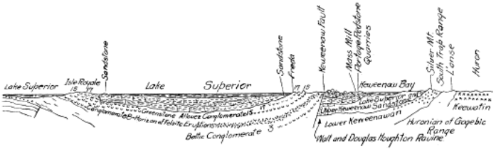
Figure 2 - http://www.michigan.gov/documents/deq/deq-ogs-gimdl-PU06A_304809_7.PDF

Tectonic activity in the area soon quieted. At that time, the area was left alone to weather and erode, and the fault was buried under sedimentary rock. More recently, within the last 2 million years, a period of glacial activity has exposed the fault again by carving away the softer sedimentary rock (sandstone) under which it was buried. As the glaciers retreated, glacial runoff carved out the landscape, and created the incredible waterfall you see at this site today.
As you observe the rocks both upstream and downstream, you may notice they don’t look the s same. They differ in color and makeup, and they differ in the way they are layered. Looking downstream first, you’ll notice the rocks are reddish and are relatively flat- lying. When you see different rock types, as you do here, with different layering patterns, it often indicates a point of geologic contact called a fault. At Hungarian Falls, the point of contact lies just below the ledges of the waterfall. Using the differing rocks as a guide, where do you think the fault line crosses the creek bed?
Figure 3: Photo by A. Ernstes
Tour of Hungarian Falls
Hungarian Falls is located in Hubbell, MI, just a few miles from Hancock, MI. Take M-26 (also called Tamarack Street) from Hancock toward Hubbell, MI. Turn left (northeast) onto Sixth Street. This will fork into Golf Course Road—take the fork to the left. Follow Golf Course road as it turns to a dirt road. The trail head is the third opening on the left (located at 47°10.383’ N, 088°26.685’ W). You can park your car here and hike in to pick up Hungarian Falls Trail. (Insect repellent and sturdy shoes are recommended for this hike.)
When you reach the split in the trail, (located at 47°10.377’ N, 088°26.894’ W) you will follow it upstream, to the right, to view the Upper Falls. Following the trail downstream, to the left, will allow you to view some more of the geology along the trail, which includes two more waterfalls – bonus!
Logging Your Visit
Logging Q1: Identify the locations of the three rock types described above (basalt, conglomerate, sandstone) relative to the waterfall itself.
Logging Q2: Describe the structure of the rock located at the peak of the waterfall. (Include size of pebbles/cobbles, colors, etc.)
Logging Q3: Compare/contrast the rock structure located at the peak of the Upper Falls to the rock found approximately 100 feet downstream. How is that helpful in determining the location of the fault line (geologic contact)?
Access Information
The Hungarian Falls Trail is under shared ownership by the Michigan Department of Natural Resources (DNR) and the Keweenaw Land Trust (KLT). KLT owns the portion of the Hungarian Falls Trail which includes the Upper Falls.
Date Visited
July 12, 2013
Vocabulary
Conglomerate – a sedimentary rock; made up of a variety of pebbles and cobbles cemented together by fine particles
Basalt – igneous rock found commonly throughout the Keweenaw Peninsula, formed by rapidly cooling lava
Rift – a zone where Earth’s crust is being pulled apart, creating a location for lava flow to occur
Thrust Fault – a break, or fracture, in rock formed in response to inward tectonic stress; rocks originating at a lower stratigraphic position are forced upward resulting in older rock atop younger rock
Earth Science Literacy Principles’ Big Ideas
4.5 Many active geologic processes occur at plate boundaries. Plate interactions change the shapes, sizes, and positions of continents and ocean basins, the locations of mountain ranges and basins, the patterns of ocean circulation and climate, the locations of earthquakes and volcanoes, and the distribution of resources and living organisms.
4.7 Landscapes result from the dynamic interplay between processes that form and uplift new crust and processes that destroy and depress the crust. This interplay is affected by gravity, density differences, plate tectonics, climate, water, the actions of living organisms, and the resistance of Earth materials to weathering and erosion.
The uplifted layers of basalt and conglomerate which are viewable at this site demonstrate that geologic processes change the landscape. In this case, the older basalt and conglomerate layers were uplifted above the younger sandstone layers as a result of the compressional force of the Grenville plate collision.
Misconceptions
1. The Earth has always been pretty much the way it is now.
2. All rocks are more or less the same.
3. Rock layers are always flat.
Connections to the Earth Science Curriculum
Middle Grades Content Standards
E.SE.06.41 Compare and contrast the formation of rock types (igneous, metamorphic, and sedimentary) and demonstrate similarities and differences using the rock cycle model.
High School Content Standards (full document includes prerequisite standards)
E3.1A Discriminate between igneous, metamorphic, and sedimentary rocks and describe the processes that change one kind of rock into another.
E3.1B Explain the relationship between the rock cycle and plate tectonics theory in regard to the origins of igneous, sedimentary, and metamorphic rocks.
E3.1c Explain how the size and shape of grains in a sedimentary rock indicate the environment of formation (including climate) and deposition.
Essential Questions:
1. How do plate movements change the landscape?
2. How can rocks that are visible today indicate the geological activities of the past?
The owner of this cache is a participant in the Michigan Teaching Excellence Program (MITEP) through Michigan Technological University, which teams with science teachers to improve science teaching and learning. This work was supported by the National Science Foundation award #0831948.
References and Citations
Lane, Alfred C. The Keweenaw Series of Michigan. Michigan Geological and Biological Survey. Publication 6, Geological Series 4, Volume 1. Retrieved July 23, 2013 from http://www.michigan.gov/documents/deq/deq-ogs-gimdl-PU06A_304809_7.PDF
United States Geological Survey. Copper Harbor Conglomerate on Isle Royale. Retrieved July 23, 2013 from http://www.nps.gov/history/history/online_books/geology/publications/pp/754-B/sec2.htm
Schaetzl, Randall J., Joe T. Darden, and Danita S. Brandt. Michigan Geography and Geology. New York: Custom, 2009. Print.