[English version below]
La región volcánica de Campo de Calatrava ocupa una superficie de más de 4500 km2 y está compuesta por cerca de 300 afloramientos de origen volcánico, en su mayor parte restos de conos formados por acumulación de material piroclástico y lavas de escaso recorrido, asi como cráteres y materiales de origen hidromagmático, debidos al contacto del magma con agua en niveles superficiales.
El volcán Cerro Gordo es un excelente lugar para observar este tipo de volcanismo, ya que incluye dos de las estructuras más características del volcanismo de esta región. En primer lugar, un cono producido por una erupción estromboliana, es decir moderadamente explosiva, en las que predomina la emisión de material piroclástico (bombas, lapilli, cenizas) y algunas coladas de lava. También se puede observar un cráter de tipo "maar" producido por una erupción hidromagmática y que hoy forma la depresión del "Barranco Varondillo". Este Earthcache os propone un recorrido por este interesante conjunto volcánico.
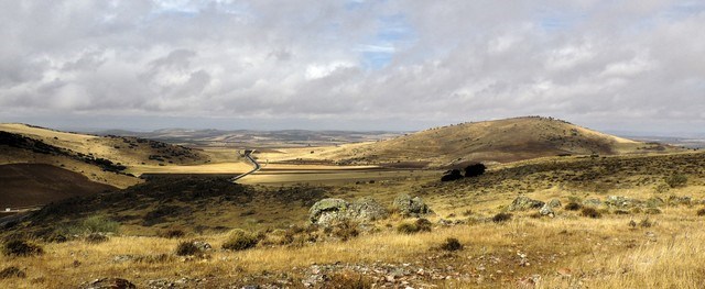 Volcán Cerro Gordo y Barranco Varondillo vistos desde el camino a La Encantada
[Cerro Gordo volcano and the Barranco Varondillo as seen from the way to "La Encantada"]
En las coordenadas del Earthcache tienes una vista de conjunto, con la elevación del cono estromboliano al NE y el maar de Barranco Varondillo al E (es la depresión que atraviesa la carretera). En este punto, verás acumulados al lado de la carretera muchos bloques de basalto (apartados durante la construcción de la vía). A tus pies encontrarás un par de bloques de basalto redondeados, con su característico color negro. Fíjate en ellos y sobre todo en la roca que asoma del suelo a su lado y que es totalmente diferente. Son cuarcitas y es el tipo de roca que forma el sustrato (basamento) sobre el que surgió el volcán. Observa su aspecto, ya que una de las preguntas está relacionada con esta roca. Ahora asciende por la ladera del volcán hacia las coordenadas adicionales R1 (no hace falta llegar a ellas exactamente). Desde aquí tienes una buena visión de la forma del maar de Barranco Varondillo.
Es el momento de poner a prueba tus dotes de observación:
- Desde tu perspectiva, ¿Qué forma aproximada tiene el barranco Varondillo? Esa es la forma típica de muchos maares.
- ¿De qué color es la roca que forma el basamento sobre la que surgió el Cerro Gordo?
- Ahora deduzcamos. En las coordendas adicionales R2 (opcionales) se puede comprobar que las lavas están cubiertas por un material arenoso de color marrón-rojizo (ver fotos). Son el material depositado por la erupción hidromagmática. Según esto, ¿Qué fue primero, la explosión hidromagmática o la erupción estromboliana?
Envía tus respuestas por mensaje privado a través de geocaching.com y loguea el "found it". Si hubiera algún problema con las respuestas, contactaríamos contigo para resolverlo. Los logs que no cumplan con los requisitos del Earthcache, serán borrados sin previo aviso.
Información importante sobre los "Reference Points" adicionales:
Excepto R1, el resto de "reference points" son todos opcionales, por los motivos que se explican: En R4 se indica una cantera que deja al descubierto la estructura del cono volcánico. Es muy interesante, pero al ser propiedad privada, su visita requiere contar con permiso. En otros waypoints (R2 y R3, ver fotos abajo) se indican algunos elementos interesantes, pero al ser una cuneta estrecha no se recomienda caminar por ella excepto para adultos y extremando las precauciones (vestir chaleco reflectante por ejemplo). Para evitar riesgos, es preferible observar desde los promontorios a ambos lados de la carretera.
A la izquierda, ejemplo de "Bomb Sag" (reference point R3). Estructura formada por un bloque o bomba al caer durante la erupción y deformar el material sobre el que se deposita. A la derecha, superposción de material de origen hidromagmático sobre las lavas con tipica disyunción "en bolas" (reference point R2)
[Left: Bom Sag (reference point R3), produced by blocks or bombs deforming the stratification as they fall during the eruption. Right: overlapping of hydromagmatic materials over the basaltic lavas that show nice spheroidal disjunction (reference point R2)]
[English version]
The volcanic region of Campo de Calatrava is constituted by about 300 volcanic outcrops scattered over more than 4500 km2. Most outcrops are eroded volcanic cones produced by accumulation of piroclasts and minor lavas. Hydromagmatic-origin craters, produced by explosive eruptions when magma gets into contact with freatic water are also common.
The Cerro Gordo volcano is a great spot to observe the characteristics of this volcanism since it encompasses both kind of structures: an strombolian cone where piroclastics (bombs, lapilli, ash) and some lava flows accumulate around the vent, and a maar-type crater produced by a highly explosive hydromagmatic eruption (today's Barranco Varondillo). This Earthcache will guide you through this volcano and its history.
At the Earthcache coordinates you have a good view of the strombolian cone to the NE and the Barranco Varondillo maar to the East (it's the basin cut by the road). In this spot you will see many basaltic blocks (accumulated there during the construction of the road). At your feet you should identify a rounded block of basalt with its typical black color. Now notice the other kind of rock that outcrops nearby that looks very different. These are quarzites and are part of the basement rocks that are below this volcano. Take a good look since this will be one of the questions to log the cache as found. Now walk up the volcano slope towards the additional waypoint R1. From here you will have a proper view of the maar crater.
It is the moment to prove your observation skills:
- From R1, what seems to be the shape of Barranco Varondillo? It happens to be one of the typical maar shapes.
- What is the color of the basement rocks?
- Now it's time to think like a geologist to guess part of the volcano history: At additional coordinates R2 (to go there is optional, you can use the picture above) you will see that the lava flows are covered by a sandy brownish material. Those are deposits by the hydromagmatic eruption. According to this, what occurred firs? The hydromagmatic eruption or the strombolian one?
Send your answers by a private message and log your "found it". We'll contact you only if there was a problem with your answers. Logs that do not send answers will be removed without warning.
Important information about the additional "Reference waypoints":
Except for R1, all remaining waypoints are optional. R4 is an impressive quarry that allows to see the internal structure of the volcano. However is in private grounds and it may require permission (sometimes you may ask for it on spot). At waypoints R2 and R3 (see photos above) you can see interesting features, but they are located at a narrow side of the road so only go at your own risk and with extreme caution. Do not take small children or pets there.