Photo: Chris Edley
Before we describe what you will see a this location, it is worth understanding a few definitions. Be patient, we'll tie the definitions together during your adventure!
The Nanaimo Group: The majority of eastern Vancouver Island is made up of an ancient volcanic rock base with overlying sedimentary rock. The sedimentary rock was laid down when the region was covered by a shallow tropical sea called the Nanaimo basin, and evidence of this can be found in the island's fossil record. Fossilized palm fronds, ammonites, and even an elasmosaurus have been found in the island's sedimentary rocks. Collectively, this layer of sedimentary rock is called the Nanaimo group, and in places it is up to 6km thick.
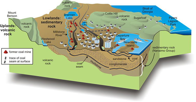
Image from Geoscape Nanaimo - Govt of Canada
The Nanaimo group consists of alternating layers of conglomerate, sandstone, mudstone, shale and coal which was deposited between 90 and 65 million years ago.

Photo: Chris Edley
Conglomerate: By definition, conglomerate is a sedimentary rock that contains large (greater than two millimeters in diameter) rounded particles. The space between the pebbles is generally filled with smaller particles and/or a chemical cement that binds the rock together. It often looks like rock that is made up of gravel, which in fact it is.
The 1700 Megathrust earthquake: On Jan 26th 1700, at 9:00pm, one of the world's largest earthquakes took place off the pacific coast of Vancouver Island. Measuring around 9.0, a 1000km long undersea section of the Cascadia subduction zone ruptured with an average 20m uprising of the seafloor. The resulting tidal wave wiped out coastal first nation's communities and caused destruction on the east coast of Japan (where accurate timekeeping allows us to pin-point the date and time).
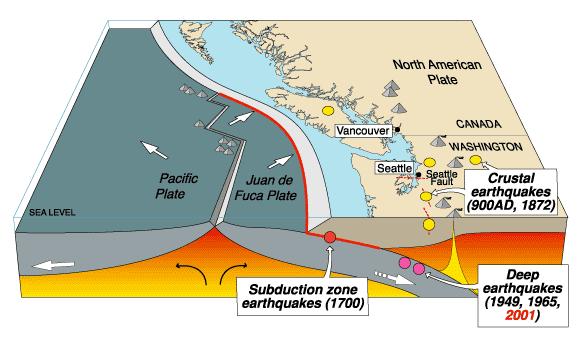
Image: Wikimedia Commons
The image above shows the location of the subduction zone where this earthquake happened. It is where the Juan de Fuca plate is "subducted" under the North American plate.
At this Earthcache location you will find a rather significant boulder. If you look at the bedrock in the area, you will notice that the boulder is quite different from the rock that it sits on, implying that it came from somewhere else. What you are looking at is a conglomerate boulder. The tops of Mt Tzuhalem, as well as nearby Mt Prevost, Mt Maxwell and others are all made up of similar conglomerate, and were in fact at one time deposited as a single continuous layer of mixed gravel, part of what makes up one layer within the Nanaimo group.
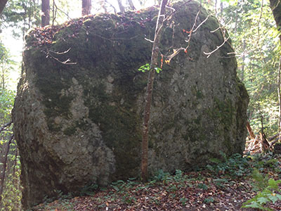
Photo: Chris Edley
Knowing that this boulder must have come from another location, one might ask where? and how did it get here? Knowing that there have been glaciers move through the region as recently as 15,000 years ago, one might be tempted to think that this was an erratic, plucked off a local hilltop and transported here at a glacial pace by the Cowichan ice tongue. The ice may have played a role, but this is in fact not an erratic. Rather, it is simply a boulder that has broken off a higher elevation of Mt Tzuhalem and rolled and bounced to its current resting place.
Two glaciers moved through this area during the last ice age, first the relatively small Cowichan ice tongue moved west to east down the Cowichan valley. This left the tops of the local mountains exposed and subject to erosion by the south-moving Cordillerian ice sheet that covered the whole area. It is likely that this ice sheet caused weakening fractures partially dislodging huge chunks of conglomerate on the local mountain tops.
Local First Nations legend has it, that a few hundred years ago the earth moved. It moved so much, and for so long that people could not stand up and they were sick from the motion. Their villages were flattened and giant boulders were shook free and came down from the mountains. Now, we happen to know a little about an earthquake that occurred at 9:00pm one day in the winter of 1700. Could it be that this boulder came to rest here on that day?
In order to log this EarthCache, send us an email (through our geocaching profile) that has the answers to the following questions:
1. Estimate the height, width and depth of the boulder.
2. What is the average size of the larger rocks that make up the conglomerate?
3. You don't have to, but we know you want to! Hug the boulder and take a pic and post it! Rocks need love too!
There are more of these conglomerate boulders to explore in the region. Take a drive towards Genoa Bay and look for them along your route.
Sedimentary rocks give clues to the environment that formed them. Fairly fast moving water must have deposited this coarse material. Dead animal or plant matter would not be able to settle and fossilize in this fast moving water. You'll notice there are no fossils in the conglomerate.