A geological unconformity is a break in the build up of sediments that formed rock.
In the Early Devonian period, about 410 million years ago, what is now Scotland was located south of the Equator. Huge rivers were bringing down sediments from eroding high land. The Arbroath Sandstone is a rock formed from these deposits - it is red, showing the presence of iron in a hot, semi-arid environment. You can see this rock in the bottom portion of the cliff if you look over the railing down towards the shore.
In the Late Devonian, around 370 million years ago, the same process continued. As well as sandstones, thick deposits of conglomerate built up. This rock is formed from river-transported pebbles cemented into a finer-grained sandy matrix. You can see this rock in front of you as you stand at the end of the road, and in the top part of the cliff as seen from the shore.
The join between these two rock types is unconformable. This means that the transition between the two was not smooth but there is a gap in the geological history - the missing millions! In this case about 40 of them. How do we know this? Because we can see the cross-section through the ancient or fossil land surface at the join.
This shows us that, between the two time periods represented by the two rock types we see, there was collision of the earth's plates causing uplift and erosion of the older rocks and the formation of a tilted and lumpy land surface. Later the conglomerate covered this surface, infilling the hollows such that the base of this younger rock is not a flat surface.
To learn more about the sandstones of the Devonian period visit GC2CXWK The Sandstone Cliffs.
James Hutton was the first geologist to recognise unconformities and their significance. You can visit some of the sites in Scotland where he demonstrated missing millions. There are earthcaches at 3 such sites: GC21VPQ, GC33ZZV and GC20KW6.
To log this earthcache you must FIRST e-mail me the answers to the following:
1) Standing at the road end or at the top of the steps down to the shore, look at the red Arbroath Sandstone. It is formed of beds or layers separated by master bedding planes, giving a slightly stepped appearance due to erosion at the joins. Within each layer you can see cross-bedding where the sand was laid down at an angle as sand-bars formed in the river. Describe the master bedding planes. From here, what apparent angle do they make with the horizontal? How straight are they?
2) Still from this viewpoint, now look at the join between the sandstone and the conglomerate. Make sure to look at the rocks above the shore because a small fault has caused about 1 metre vertical displacement of the rocks such that the join is not clearly seen directly above the road end. Describe this join. How does it differ from the master bedding planes within the sandstone?
3) Can you explain what these differences tell us about the history of the rocks you see.
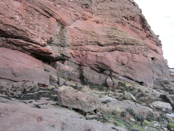
Unconformity as seen from shore
BONUS! Although the unconformity is visible from the road, and accessible to all at all states of the tide, this cross-section through the rocks is complemented by the one at right-angles to it, that is in the cliffs running along the shore. In fact the differences are much more marked in the cliffs as seen from the shore and we would encourage anyone who has the chance to explore further.
PLEASE NOTE: The shore is only accessible for about 3 hours either side of low tide. Also the rocks and stones are slippery changing the terrain rating to 2.5. DO NOT VENTURE TOO CLOSE UNDER THE CLIFFS as they are UNSTABLE!! A good view can be had from the given waypoint.
4) (optional)From here, what is the apparent angle of the lower beds to the horizontal? What is the angle of the upper ones? How can we explain the difference?
[Link to tide timetable]