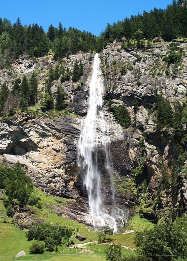
 Fallbach Waterfall, source: wikipedia.org (S. Moeller)
[English]
Maltatal valley is sometimes called "Valley of Falling Waters" because of the many waterfalls in the area, especially during snow-melt season. Fallbach Waterfall is approx. 200 meters high and it is the highest in Carinthia.
If you are going to have a closer look at the waterfall (not necessary to log the earthcache), you can observe the impact of the water to the bedrock material, which granite is here. Actually, in comparison with other rocks like limestone or sandstone, the impact is relatively low, because granite is very hard. Why is that so? Let's have a look at some interesting facts about granite that help explain it.
Granite is made of large mineral grains, which can be seen on the surface, and this is also where the name comes from (the Latin word "granum", to be precise). Granite consists of the minerals quartz and feldspar, and usually some more accessory minerals that determine the final color tone.
It is an igneous rock, which means that it is formed from magma - it solidified from a fluid state. The random arrangement of grains reminds us of its plutonic origin - it solidified in a large, deeply buried body (pluton).
Granite is usually found in the continental plates of the Earth's crust.
By the way, have you known that granite is radioactive?
[Deutsch]
Maltatal wird manchmal auch als "Das Tal der stürzenden Wasser" wegen der vielen Wasserfälle in der Gegend, vor allem während der Schneeschmelze, genannt. Der Fallbach Wasserfall ist 200 Meter hoch, und ist der höchste in Kärnten.
Wenn Sie näher am Wasserfall sind (nicht notwendig, um den Earthcache zu loggen), können Sie die Auswirkungen des Wassers auf das Grundgestein beobachten, welches hier Granit ist. Im Vergleich zu anderen Gesteinen wie Kalkstein oder Sandstein, sind die Auswirkungen relativ gering, weil Granit sehr hart ist. Warum ist das so? Werfen wir einen Blick auf einige interessante Fakten über Granit, die es erklären helfen.
Granit besteht aus großen mineralischen Körnern, die wir auf der Oberfläche sehen können; daher kommt auch der Name (vom lateinischen Wort "granum"). Granit besteht aus den Mineralien Quarz und Feldspat und in der Regel aus weiteren zusätzlichen Mineralien, die den endgültigen Farbton bestimmen.
Er ist ein Vulkangestein, was bedeutet dass er aus Magma besteht - erstarrt aus seinem flüssigen Zustand. Die zufällige Anordnung der Körner erinnert uns an seine plutonische Herkunft - er verfestigt sich in einem großen, tief vergrabenen Körper (Pluton).
Granit wird in der Regel in den kontinentalen Platten der Erdkruste gefunden.
Übrigens, wussten Sie, dass Granit radioaktiv ist?
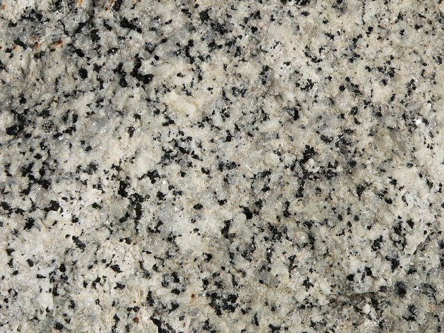 granite surface / Oberfläche des Granits, source: wikipedia.org (David Monniaux)
[English]
To log the earthcache, please send the answer to the following question to my profile. You don't have to wait for permission to log - if there is anything to improve, I will let you know.
Question
At the parking place, there is a big picture of the mountains above the waterfall. You can observe the sharp edges at their upper parts - the rain water and streams simply do not have enough power to erode the granite as much as e.g. limestone. But there is one mountain which looks a bit different - not the very top, but both saddles to the left and right and the valleys going down are eroded significantly more. Explain what could have had enough power to shape the hard stone.
Optional: Please attach a photo showing yourself (or your GPSr) and the waterfall to your log.
For a closer access to the waterfall, an entrance fee of 4,00 EUR is to be paid (not needed to answer the question). The opening hours are 9-18 (May to September) or 10-17 (first half of October).
Information from August 2013
By paying the entrance fee, you also get access to the amusement park along the path to the waterfall - very popular with children.
[Deutsch]
Um den Earthcache zu loggen, senden Sie mir bitte die Antwort auf die folgende Frage über mein Profil. Sie brauchen nicht auf die Logfreigabe warten - sollte etwas nicht stimmen, werde ich Ihnen Bescheid geben.
Frage
Auf dem Parkplatz gibt es ein großes Bild von den Bergen über dem Wasserfall. Beachten Sie die scharfen Kanten am oberen Teil - das Regenwasser und die Bäche haben einfach nicht genug Kraft um den Granit so sehr wie z. B. Kalkstein zu erodieren. Aber es gibt einen Berg, der ein bisschen anders aussieht - nicht der Gipfel, aber die beiden Sättel links und rechts und die Täler hinunter sind deutlich mehr erodiert. Erklären Sie, was genug Kraft hätte um den harten Stein zu formen.
Freiwillig: Bitte hängen Sie ein Foto von sich (oder Ihrem GPS) und dem Wasserfall an Ihren Log.
Ein näherer Zugang zum Wasserfall ist zum Eintrittspreis von 4,00 EUR möglich (nicht erforderlich um die Frage zu beantworten). Die Öffnungszeit ist von 9 bis 18 Uhr (Mai bis September) oder von 10 bis 17 Uhr (erste Hälfte des Oktobers).
Informationen ab August 2013
Im Eintrittspreis ist auch der Zugang zum Erlebnispark auf dem Weg zum Wasserfall enthalten - sehr beliebt bei Kindern.
Source / Quelle:
www.geologynet.com/granite1.htm
geology.about.com/od/more_igrocks/a/granite.htm
voices.yahoo.com/facts-granite-rock-5400537.html
Wir gratulieren Nofx Woldo für den FTF!