Lake Malawi is approximately 570 kilometres (355 miles) long, about 75 kilometres (47 miles) wide at its widest point and 700 m deep. The total surface area of the lake is about 29,600 square kilometres (11,400 sq mi).
The lake has shorelines on western Mozambique, eastern Malawi, and southern Tanzania. The largest river flowing into it is the Ruhuhu River, and there is an outlet at its southern end, the Shire River, a tributary that flows into the very large Zambezi River in Mozambique.
The rift valley and the lakes in it including Lake Victoria, Lake Tanganyika and Lake Malawi were created due to tectonic activity that started around 40 million years ago, relatively recently in Earth's history. The African tectonic plate is splitting in two.
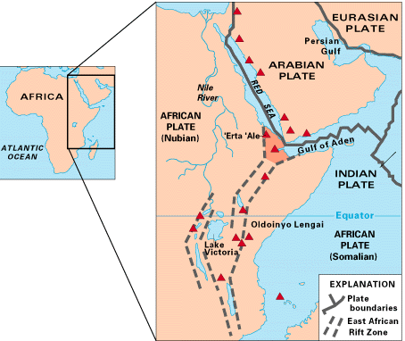
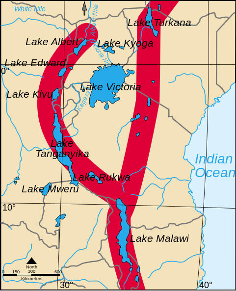
The above maps show the rift valley system that starts at the subsea tectonic plate at the south end of the Red Sea near the Gulf of Aden and extends southwards to the Indian Ocean in Mozambique. Lake Tangangika is in a western arm of the rift valley system and Lake Victoria is between the two arms that combine to forn the section where Lake Malawi is located.
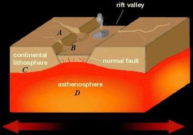
The above diagram shows the processes involved in creating a rift valley.
1. Using A, B, C and D in the above diagram, describe the tectonic processes creating the rift valley in which Lake Malawi is located.
2. Are there any active or dormant volcanoes in the rift valley. If so name an active and an inactive one?
3. At the cache location there is an information stone. What is written on it and what is the significance with regards to the geology of the EarthCache?
Please post as many nice photos with your log as you like.
In accordance with EarthCache guidelines this is how to log the cache: Send your answers to me via the "Message this owner" link under the cache name at the top of the page. After the answers are sent you can log your find straight away, no need to wait for an answer. If there is something wrong with the answers or I think you havn't actually visited, I will contact you directly. Thanks for your visit.