Tämä Solvallan muinaisranta on konkreettinen todiste Nuuksion järviylängön muodostumisesta tuhansien vuosien aikana.
Nuuksio on ainutlaatuisen upea kallioylänköjen, järvien, lampien, purojen ja yhtenäisten metsäalueiden ja soiden muodostama erämaa-alue Espoon, Vihdin ja Kirkkonummen rajamailla. Nuuksio on syntynyt monen peräkkäisen jääkauden tuloksena. Noin 20 000 vuotta sitten Nuuksion päällä lepäsi kolmen kilometrin paksuinen jääkerros. Ilmaston lämpenemisen myötä jään reuna alkoi vetäytyä kohti pohjoisia napaseutuja. Vielä reilut 10 000 vuotta sitten jäänreuna oli Nuuksion kohdalla yhä liikkeessä kohti pohjoista. Jään sulaminen ei kuitenkaan ollut suoraviivaista. Tuhansien vuosien aikana jää vuoroin laajeni ja paksuni, vuoroin vetäytyi ja suli. Tämän edestakaisen liikkeen seurausta ovat monet näkyvimmät jääkauden merkit kuten esim. Salpausselät ja muut harjumuodostelmat. Jään vetäydyttyä jäämassojen alle painunut maankuori alkoi kohota ja kohoaa edelleen. Aluksi kohoamisvauhti oli nopeampi, nykyään maa kohoaa n. 25 cm sadassa vuodessa.
N. 11 000 vuotta sitten Nuuksio oli muinaisen Baltian jääjärven pohjaa. Kun pohjoiseen vetäytyvä jäänreuna repäisi irti sillan Keski-Ruotsista Euroopan mantereeseen, valtavat vesimassat pääsivät vyörymään Baltian jääjärvestä Pohjanmereen ja Atlanttiin ja vedenpinta laski Nuuksion kohdalla useita kymmeniä metrejä. Tällöin järviylängön korkeimmat seudut ilmestyivät näkyviin veden alta hajanaisena saaristona.
Veden alta paljastuneen järviylängön kaikkein ylimpiin kalliopainanteisiin jäi vettä, ja näin saivat alkunsa nyky-Nuuksion ensimmäiset lammet kuten esim. Pieni Majaslampi 97 metrin korkeudella. Nuuksion Pitkäjärvi, joka on paljon alempana, muuttui meren vuonosta itsenäiseksi järveksi paljon myöhemmin. Silloin viimeisetkin Nuuksion 140 järvestä ja lammesta olivat muodostuneet omiksi vesialtaikseen.
Nuuksion suurimmat järvet (Nuuksion Pitkäjärvi, Poikkipuolinen, Velskolan Pitkäjärvi, Saarijärvi ja Salmijärvi) lainehtivat jään käsittämättömän ruhjovan voiman synnyttämissä murroslaaksoissa.
Suurin osa Nuuksion järviylängöstä on 60-100 m merenpinnan yläpuolella olevia kalliomaita, joita peittää korkeintaan ohut maakerros. Kallioperä on 1900-1800 miljoonaa vuotta vanhaa suomalaista peruskalliota, punertavaa graniittia tai harmaampaa granodioriittia. Nuuksion syntyhistoriasta kertovat muinaisrannat, siirtolohkareet ja hiidenkirnut. Jään työ näkyy myös lohkareikoissa, silokallion uurteissa, sulavan jään sisällä syntyneissä moreenikerrostumissa ja sulamisvesien kasaamissa hietikoissa.
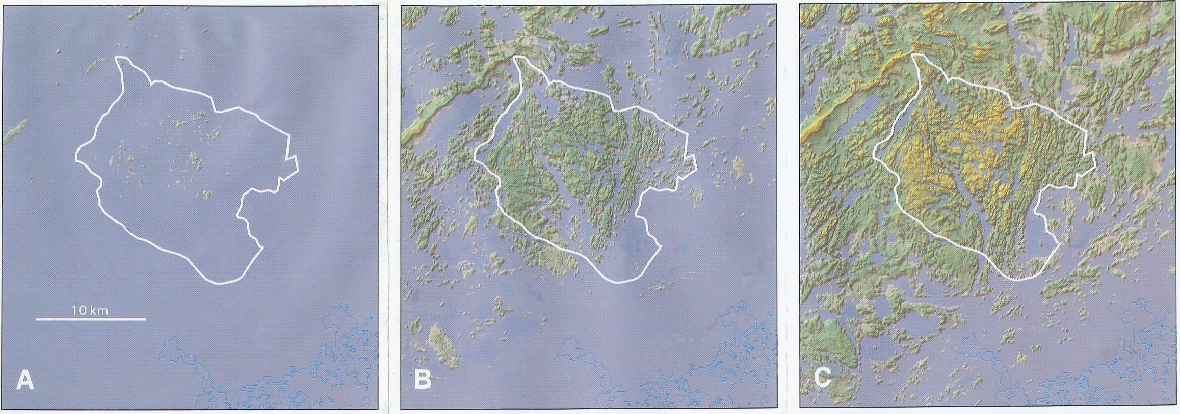

A - Yoldiameri n. 11 000 vuotta sitten - Yoldia Sea ca. 11 000 years ago
B - Ancylusjärvi n. 10 000 vuotta sitten - Ancylus Lake ca. 10 000 years ago
C - Ancylusjärvivaihe päättyy n. 9000 vuotta sitten - end of Ancylus Lake stage ca. 9000 years ago
D - Litorinameri n. 5 700 vuotta sitten - Litorina Sea ca. 5 700 years ago
E - Nuuksion järviylänkö nykyään - Nuuksio Lake Upland today
Loggausehdot: Lähetä vastaukset alla oleviin kysymyksiin kätkön omistajalle. Sen jälkeen voit logata kätkön. Jos vastauksessa on jotakin tarkistettavaa, omistaja ottaa yhteyttä.
- Minkä vaiheen muinaisrannasta on kyse, mikä on sen ikä informaatiotaulun mukaan? Mitä johtopäätöksiä voit tehdä Nuuksion synnystä tämän paikan perusteella?
- Tutki yllä olevia kuvia Nuuksion järviylängön muodostumisesta. Milloin Nuuksion Pitkäjärvestä tuli itsenäinen, merestä irrallinen järvi?
- Tutki kuvia ja etsi tarvittaessa lisätietoa. Mikä on ollut jäänreunan vetäytymissuunta?
- Ota kuva itsestäsi ja/tai GPS-laitteestasi informaatiotaulu taustalla ja liitä se logiisi TAI arvioi muinaisrannan koko.
Solvalla Ancient Shore gives concrete evidence of the birth of this area during thousands of years.
Nuuksio Lake Upland is a unique and beautiful wilderness area with rocky uplands, lakes, ponds, creeks, forests and marshes located in Espoo, Vihti and Kirkkonummi municipalities. Nuuksio came about as a result of several ice ages. About 20 000 years ago on top of Nuuksio there was a 3 km thick layer of ice. When the climate became warmer ice started to retreat towards arctic areas. A little over 10 000 years ago ice was still on Nuuksio and moving northwards. However, the deglaciation process was not straight forward. During the whole period there were times when ice cover became vaster and thicker and other times when it became thinner. This movement forwards and backwards caused many of the most visible traces of the Ice Age, such as Salpausselkä and other sand ridges. When the ice sheet retreated Earth's crust, which had been pressed downwards several hundred metres by billions of tons of ice, started to rise to its former position. At first this happened faster, nowadays the land rises about 25 cm in 100 years.
About 11 000 years ago as the area was released from the grip of the ice sheet Nuuksio was covered by the Baltic Ice Lake. When the retreating ice sheet tore apart the bridge between Middle Sweden and the European Continent huge water masses were released from the Baltic Ice Lake to the North Sea and Atlantic and the water level in Nuuksio area went down. At that time the highest points of the lake upland rose from the water and formed a kind of archipelago.
In the rock bed of the exposed land there were cavities and indentations filled with water from the melted ice. These formed the first lakes and ponds in Nuuksio. They are the ones located highest up, e.g., Pieni Majaslampi which is 97 metres above the sea level. Nuuksion Pitkäjärvi which is on a much lower level was formed much later. At that time the last of 140 lakes and ponds became their own independent lakes.
Waters of the biggest lakes of Nuuksio (Nuuksion Pitkäjärvi, Poikkipuolinen, Velskolan Pitkäjärvi, Saarijärvi and Salmijärvi) lie in corges and valleys formed by the enormous crushing power of the ice.
Most part of the Nuuksio Lake Upland is rocky land with only a thin layer of earth if any. The rocks are 1900-1800 million year old Finnish bedrock, reddish granite or greyish granodiorite.
Traces that tell about the birth of this area and can be seen in many places in Nuuksio are, e.g., ancient shores, erratic boulders and giant's cauldrons as well as morayne layers formed inside melting ice and sands piled by melting waters.
Logging requirements: Send answers to the following questions to the cache owner and log the ec. If there is something in the answer that needs clarifying, the owner will contact you.
- According to the information plate, what ancient shoreline is in question and what is its age? On the basis of this site, what can you tell about the age and formation of Nuuksio?
- Study the pictures above. When did Nuuksion Pitkäjärvi become an independent lake, disconnected from the sea?
- Study the pictures and look for additional info. What was the direction of retreating ice?
- Take a picture (optional) of yourself and/or your GPS with the information plate on the background and place it on your log OR estimate the size of the shore.
Lähteet - Sources:
- Nuuksion Järviylänkö. Geologinen retkeilykartta. Geologian tutkimuskeskus. Espoo 2001
- Leivo Mauri. Nuuksio miljoonan ihmisen erämaa. Kustannusosakeyhtiö Tammi. Helsinki 2003