The Edge: on the top of Risco Waterfall Traditional Geocache
The Edge: on the top of Risco Waterfall
-
Difficulty:
-

-
Terrain:
-

Size:  (regular)
Please note Use of geocaching.com services is subject to the terms and conditions
in our disclaimer.
[PT] Esta cache localiza-se na Lagoa do Vento, junto ao topo da queda de água do Risco. Respire fundo e aprecie a magnífica paisagem sobre o vale do Rabaçal.
[ENG] This cache is located at Lagoa do Vento near the edge of the waterfall known as Risco. Take a deep breath and enjoy the magnificent scenery over the Rabaçal valley.

Nominated for the 'Portuguese GPS Awards 2013' - Obtained the 7th position in the final classification (Madeira Archip.) among the 39 nominated caches
Nomeada para os 'Prémios GPS 2013' - Obteve a 7ª posição na classificação final (Arq. da Madeira), entre as 39 caches nomeadas
Video: Rabaçal, Ribeira do Lajeado, Lagoa do Vento (Autor/Author: Hugo Camara)
[ENG] View English version bellow…
[PT]
Este é um percurso efetuado no interior do urzal de altitude (Erica sp.) e da floresta nativa da Ilha da Madeira, a Laurissilva, pelo que é garantido encontrar pelo caminho muita vegetação, ribeiros bonitos e vistas absolutamente fantásticas sobre o vale do Rabaçal. A cache está localizada na Ribeira Grande ou do Lajeado, junto à Lagoa do Vento, uma das muitas lagoas que se encontram ao longo deste curso de água e que o desafiam para um mergulho no mínimo (muito) refrescante.
A CACHE
Para procurar a cache, e considerando que o sinal de GPS é fraco nesta zona, veja as fotos spoiler e localize as “vistas de/para a cache”. O novo container está escondido no trilho de acesso à Lagoa do Vento; antes de chegar ao final do trilho, procure à sua esquerda (sentido descendente); não precisa de sair do trilho!
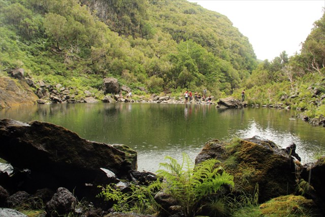
- Lagoa do Vento.
PERCURSO SUGERIDO
(ida e volta: ca. 8 Km; com passagem pela Lagoa D. Beja: ca. 9.5Km)
O percurso tem início junto à estrada que dá acesso ao Rabaçal, perto do parque de estacionamento. Procure o trilho junto da barreira que impede a passagem de viaturas para a estrada, siga pela direita (waypoint T1), e continue a caminhar até encontrar a Levada do Alecrim, poucos metros à frente. Percorra a levada até se deparar com uma descida, à esquerda (waypoint T2), que o conduzirá até à Lagoa do Vento. Mas antes de descer, considere a sugestão de continuar em frente até ao início da levada, onde vai encontrar a Lagoa D. Beja; verá que será recompensado, pelos cerca de 25 minutos extrapercurso (ida e volta), com uma paisagem excecional, podendo ainda fazer a cache “BisBis”. Aproveite e disfrute do momento para descansar um pouco e regresse a T2.
- Sugerimos que faça um desvio e visite a Lagoa D. Beja.
- We suggest you take a detour and visit the Lagoon D. Beja.
A descida faz-se entre o urzal de altitude, constituído essencialmente pela “Urze das Vassouras” (Erica platycodon maderincola), uma espécie de arbusto endémico da Madeira. A meio caminho vai se cruzar com um trilho antigo (waypoint T3) pelo que não se deve desviar do seu caminho que é sempre a descer. Aproveite para fazer, mais abaixo (desvio à direita), a cache do “Pico do Vento”.

- Na descida, passagem entre o urzal de altitude.
- On your way down, in the middle of the heath of high-altitude.
Após uns 40 minutos de caminhada vai encontrar uma bifurcação (waypoint T4), vire à direita para descer até a Lagoa do Vento.

- Na descida, quase a chegar à Lagoa do Vento.
- On your way down almost reaching the Lagoa do Vento.
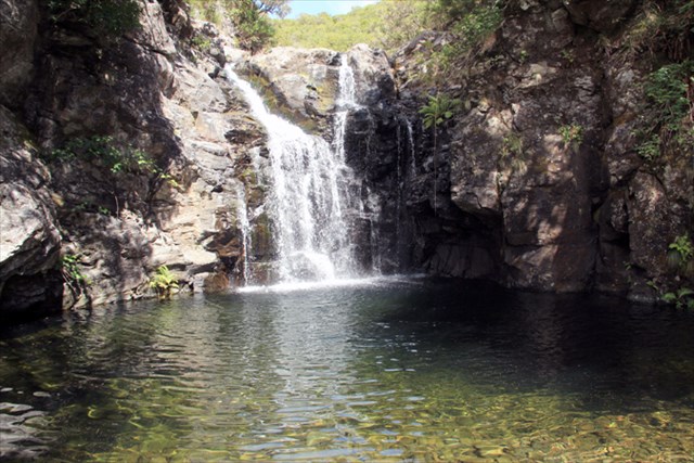
- Vista para a queda de água da Lagoa do Vento.
- View to the waterfall Lagoa do Vento.
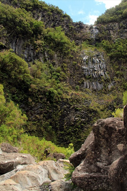
Chegado ao local, dê uso à sua câmara fotográfica e registe este pequeno lago esculpido a meio da escarpa, para mais tarde recordar. Se o caudal da ribeira o permitir, poderá descer um pouco pelo seu leito e desfrutar de uma paisagem única sobre o redondo do Risco, conhecido pela sua queda de água que se precipita ao longo de uma parede com cento e muitos metros de altura. Observe também o manto verde que cobre o vale do Rabaçal, mas faça-o com muito cuidado e não se aproxime da beira da escarpa, mantenha-se em segurança.

- No limite da escarpa, vista sobre o vale do Rabaçal.
- Looking over the Rabaçal valley in the edge of the cliff.

- No limite da escarpa, vista para baixo!
- Looking down in the edge of the cliff!
Para regressar ao ponto de partida deve voltar ao waypoint T4, seguindo depois em frente até T5, a partir do qual terá de percorrer cerca de 2 km de estrada, até ao parque de estacionamento.
PERCURSO ALTERNATIVO
(ida e volta ca. 8 Km)
Se quiser considerar um percurso alternativo ao apresentado anteriormente, pode optar por descer a estrada e iniciar a vereda em T5. Siga até T4 e depois desça até a Lagoa do Vento.
Recomenda-se: Calçado apropriado para caminhadas, casaco e impermeável, água para beber.
Cuidados a ter: Tenha atenção aos precipícios e ao piso escorregadio.
Nota: No inverno deverá redobrar a sua atenção ao longo do trilho e ter muito cuidado com o piso escorregadio. Se não estiverem reunidas as condições meteorológicas mínimas evite fazer o percurso.
[ENG]
This is a walking track made within the heath of high-altitude (Erica species) and native forest of Madeira, the Laurel Forest, so it is guaranteed that you will find along the path a lot of vegetation, beautiful streams and scenic views absolutely fantastic over the valley of Rabaçal. The cache is located in Ribeira Grande or Lajeado, near Lagoa do Vento, one of the many lakes that lie along this watercourse which challenge you for a (very) refreshing swim
THE CACHE
To find the cache and considering that the GPS signal is weak in this area see the spoiler photos and locate the "view to the cache/from the cache". The new container is hidden over the trail that takes you to the lagoon (Lagoa do Vento); search it before arriving to the end of the trail, on your left side (going down); you do not need to get outside the trail!
SUGGESTED TRAIL
(Full roundtrip: ca. 8 Km; inluding a visit to the lagoon D. Beja: ca. 9.5Km)
The trailhead begins near the road that leads you to Rabaçal, close to the parking. Look for it on the right side of the barrier which is blocking the entry of vehicles on the road (waypoint T1), and continue walking until you find the Levada do Alecrim a few meters ahead. Follow the ‘levada’ path until you find on your left a descent trail (waypoint T2) which will lead to the Lagoa do Vento. But before going down consider the suggestion to continue along the ‘levada’ until its start in the riverbed. There you will find the beautiful lagoon of D. Beja - you will be rewarded for the extra 25 minutes’ walk (full roundtrip) with an exceptional natural scenery and with the possibility of logging the cache “BisBis”. Enjoy the moment to take a break and return to T2 to go down to Lagoa do Vento.
From T2, the descent path is made between the high-altitude heath mainly constituted by Erica platycodon maderincola an endemic shrub of Madeira used in the old days to make brooms. Halfway down you will find an intersection with a former trail (waypoint T3) however the wright path is strait down. A few meters down you will have the chance to search for the cache “Pico do Vento”.
After a total of 40 minute walk will find a crossing of trails (waypoint T4), turn right to go down to the Lagoa do Vento.
On your arrival take your camera and register this small and beautiful lake carved in the middle of this cliff to be remembered later. If the river flow allows you to get down safely follow the riverbed down and enjoy a unique landscape over near the Risco waterfall, known for its huge cliff that plunges through a wall with more than a 100 meter high. Observe the green mantle that covers the valley of Rabaçal but do it very carefully and do not approach the edge of the cliff, keep yourself safe!
To return to the starting point (T1) you must return to the waypoint T4 then straight ahead to T5. From here you will have to go up through about 2 km of road until the parking area.
ALTERNATIVE TRAIL
(full roundtrip: ca. 8 Km)
If you wish to consider an alternative route to the one shown above, you can choose to go down the road toward T5 and start there. Follow the path until T4 and then go down to the Lagoa do Vento.
Recommended: Proper footwear for hiking, waterproof jacket and water to drink.
Cautions: Watch out for cliffs and slippery floor.
Note: During the Winter you must redouble your attention along the trail and be very careful with the slippery floor. If not fulfilled the minimum weather conditions avoid making this walking.
Additional Hints
(Decrypt)
Sraqn, qronvkb qn crqen - bhgenf qvpnf ab grkgb. Penpx, haqre gur fgbar - zber uvagf va gur grkg.